

Short entry1.4 miles away
Red Rocks Marsh
Stanley Road and the shore south of Hoylake, Wirral · Coastal sand dunes, reedbed and marsh
 the ai birderBirding near me
The AI Birder · one-page field sheet
Off West Kirby, Wirral · CH48 0QA

Brent Goose · Turnstone · Dunlin · Oystercatcher · Curlew · Redshank
South-end public island path · North-end public path by the former lifeboat station · Main-island grass paths · Observatory seawatching hide (arranged visits only)
Check current access, hide closures and operator notices before travelling. Seasonal birds are possibilities, not promised sightings. Keep to authorised routes and give wildlife space.
Opening and charges checked 2026-10-18. Operator: https://www.wirral.gov.uk/leisure-parks-and-events/parks-and-open-spaces/find-park-or-open-space/hilbre-islands-local-nature
Full guide and current source links: https://aibirder.co.uk/reserves/hilbre-island-and-bird-observatory
EN 69 · Wirral Council reserve guide
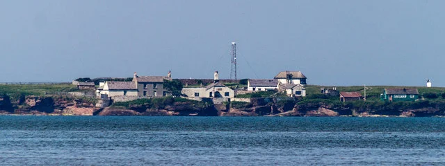
Off West Kirby, Wirral
Brent geese, purple sandpipers, migration watches and offshore grey seals
Decide if the visit fits.
Last checked 18 October 2026.
Opening and charges information · checked .
Stay nearby →Reserve overview
Brent geese, purple sandpipers, migration watches and offshore grey seals
Eight checks for a smoother visit.
Conditions change: check the operator and transport notices before travelling.
January: typically look for Brent Goose from South-end public island path, provided the council’s low-water crossing window and daylight allow the visit. Set the island departure time before starting; no bird report justifies staying beyond it. February: typically look for Common Scoter from North-end public path by the former lifeboat station, provided the council’s low-water crossing window and daylight allow the visit. Set the island departure time before starting; no bird report justifies staying beyond it. March: typically look for Rock Pipit from Main-island grass paths, provided the council’s low-water crossing window and daylight allow the visit. Set the island departure time before starting; no bird report justifies staying beyond it. April: typically look for Wheatear from Main-island grass paths, provided the council’s low-water crossing window and daylight allow the visit. Set the island departure time before starting; no bird report justifies staying beyond it. May: typically look for Wheatear from Main-island grass paths, provided the council’s low-water crossing window and daylight allow the visit. Set the island departure time before starting; no bird report justifies staying beyond it. June: typically look for Oystercatcher from South-end public island path, provided the council’s low-water crossing window and daylight allow the visit. Set the island departure time before starting; no bird report justifies staying beyond it. July: typically look for Cormorant from North-end public path by the former lifeboat station, provided the council’s low-water crossing window and daylight allow the visit. Set the island departure time before starting; no bird report justifies staying beyond it. August: typically look for Turnstone from South-end public island path, provided the council’s low-water crossing window and daylight allow the visit. Set the island departure time before starting; no bird report justifies staying beyond it. September: typically look for Wheatear from Main-island grass paths, provided the council’s low-water crossing window and daylight allow the visit. Set the island departure time before starting; no bird report justifies staying beyond it. October: typically look for Brent Goose from South-end public island path, provided the council’s low-water crossing window and daylight allow the visit. Set the island departure time before starting; no bird report justifies staying beyond it. November: typically look for Dunlin from South-end public island path, provided the council’s low-water crossing window and daylight allow the visit. Set the island departure time before starting; no bird report justifies staying beyond it. December: typically look for Song Thrush from Main-island grass paths, provided the council’s low-water crossing window and daylight allow the visit. Set the island departure time before starting; no bird report justifies staying beyond it.
Best conditions: Usually choose calm, clear weather and a low-water window comfortably inside daylight. Strong wind, poor visibility and slippery rocks can make a nominal tide window unsuitable. Watch feeding birds from the public paths and keep away from flock concentrations. A scope helps identify distant sea ducks; never use it as a reason to delay the return crossing.
Wirral Council manages Hilbre Islands Local Nature Reserve. Its visitor information checked on 18 October 2026 publishes no island admission charge or ticket booking requirement; access is on foot and depends on the tides. There is a pay-and-display car park at Dee Lane on the mainland. A current tariff for that car park was not established from the council reserve page, so use the displayed charges rather than assuming parking is included in the island visit. This guide uses the council's recommended low-water visit. The council's conservation plan says to start from West Kirby no earlier than three hours after high tide and to leave the island at least three hours before the next high tide. Read that day's official tide times, including the correct GMT or BST, and the Dee Lane noticeboard before departure. Weather can make a nominal tidal window unsuitable. The council no longer publishes instructions for crossing out and remaining over high tide: do not plan such a stay from older advice.
Access times: Reserve: Tidal pedestrian access only: council plan says start from West Kirby no earlier than three hours after high water and leave the island at least three hours before the next high water. Use daylight and current advice. · Hides: Observatory and seawatching hide visits require arrangements or an advertised event; no daily public hide opening is promised. · Car park: Mainland Dee Lane parking is separately managed; current gate hours are not verified here. · Dawn access: partly. Operator opening information.
The only council-recommended mainland starting point is the Dee Lane slipway beside West Kirby Marine Lake. Follow the recommended line towards Little Eye, keeping that smallest island on your right. After passing it, turn right, with Middle Eye on your left. The council describes the final approach over the rocks towards Hilbre's southern end, with an alternative using the steps over Middle Eye. Read the council's map on site and do not improvise a direct line to the main island. Never cross directly from Hoylake or Red Rocks, or head straight from West Kirby towards Middle Eye or Hilbre: deep tidal channels lie on their eastern sides. The council gives approximately 45 minutes to an hour for the recommended outward walk. Leave ample time for a return that can take longer when people are tired or the surface is awkward. The whole party should agree a turning time before reaching the island. On Hilbre, stay with the existing paths and durable rocky ground. The grassland, sandstone shore and seaward outlook offer different birdwatching, while the historic buildings add context without requiring entry to private rooms. The observatory is a working place for monitoring migration and licensed ringing. Public visits are by appointment, not guaranteed simply because a member is present. Two-hour plan: two hours total is too compressed to promise a relaxed island visit with both crossings. Use that allowance for a mainland watch from West Kirby, or extend it sufficiently to include the council's expected walking time, a useful island stay and a generous return margin. Never shorten the safe route to make an arbitrary itinerary work. Full-day plan: choose a day when the permitted low-water window overlaps daylight, walk out with a comfortable margin, and divide the island stay between migration watching on the paths and a seaward scan. Return well within the council's required departure limit, then spend the remaining day in West Kirby. A full day does not require remaining on the island throughout it.
Use the linked reserve map and directions with current access notices. Species are typical seasonal targets. Light and telescope advice reflects our choice of viewpoint.
Rocky shore and surrounding feeding flats
Watch from the public path; do not approach shore flocks or enter channels.
Winter: Brent Goose, Turnstone, Dunlin, Oystercatcher
Spring: Brent Goose, Redshank
Summer: Oystercatcher, Curlew
Autumn: Turnstone, Curlew, Dunlin
Light: either. Scope: useful.
Open sea and offshore channels
Stay on the island path, away from damaged slipways and cliff edges.
Winter: Common Scoter, Red-throated Diver
Spring: Common Scoter, Cormorant
Summer: Cormorant, Herring Gull
Autumn: Common Scoter, Cormorant
Light: either. Scope: essential.
Grassland, low vegetation and buildings
Public paths only; buildings and observatory are not freely accessible.
Winter: Rock Pipit, Wren, Blackbird, Song Thrush
Spring: Rock Pipit, Wheatear
Summer: Rock Pipit, Wren
Autumn: Wheatear, Rock Pipit
Light: either. Scope: not needed.
Sea beyond the north-west shore
Council identifies the observatory hide as an arranged group/event facility; do not assume public entry.
Winter: Common Scoter
Spring: Cormorant
Summer: Cormorant
Autumn: Common Scoter
Light: either. Scope: essential.
| Spot | Overlooks | Key species by season | Best light | Scope | Tide |
|---|---|---|---|---|---|
| South-end public island pathWatch from the public path; do not approach shore flocks or enter channels. | Rocky shore and surrounding feeding flats | Winter: Brent Goose, Turnstone, Dunlin, Oystercatcher Spring: Brent Goose, Redshank Summer: Oystercatcher, Curlew Autumn: Turnstone, Curlew, Dunlin | either | useful | — |
| North-end public path by the former lifeboat stationStay on the island path, away from damaged slipways and cliff edges. | Open sea and offshore channels | Winter: Common Scoter, Red-throated Diver Spring: Common Scoter, Cormorant Summer: Cormorant, Herring Gull Autumn: Common Scoter, Cormorant | either | essential | — |
| Main-island grass pathsPublic paths only; buildings and observatory are not freely accessible. | Grassland, low vegetation and buildings | Winter: Rock Pipit, Wren, Blackbird, Song Thrush Spring: Rock Pipit, Wheatear Summer: Rock Pipit, Wren Autumn: Wheatear, Rock Pipit | either | not needed | — |
| Observatory seawatching hide (arranged visits only)Council identifies the observatory hide as an arranged group/event facility; do not assume public entry. | Sea beyond the north-west shore | Winter: Common Scoter Spring: Cormorant Summer: Cormorant Autumn: Common Scoter | either | essential | — |
Month chips show typical presence or our preferred viewing season. Choose birds that suit the time of your visit.
Follow the council’s low-water visit: leave West Kirby no earlier than three hours after high water; depart Hilbre at least three hours before the next high water. Use the approved West Kirby–Little Eye–Middle Eye route, current ranger advice and daylight. Never cross directly from Hoylake or Red Rocks, take channel shortcuts, or plan to remain over high tide.
Hilbre is reached on foot across wet sand and rocks. The council describes soft sand, uneven tracks and gradients on and around the islands; the final approach also involves rough rock and, on one option, steps. This is a demanding access proposition for a wheelchair, mobility scooter or anyone with balance difficulties. Do not assume that a firm-looking strip of sand will remain firm or dry for the return. Discuss the actual walk with the council's countryside service before attempting it with a mobility aid. A mainland watch may provide the more comfortable outing, particularly when progress is slow or rests are essential. The tidal return deadline needs to accommodate the slowest member of the party without anyone being pushed beyond their capacity. Wear secure footwear with grip and protect against both wind and rain. The council advises against walking barefoot because the route includes wet rocks and potentially sharp surfaces. Carry layers that remain useful while standing still on the island. Mobile reception depends on the network and should not be the only means by which the party understands its route and departure time.
The council lists toilets, a small wet-weather shelter with benches and the Telegraph Station information centre. There is no café on Hilbre. The Friends sometimes provide tea and coffee on their organised open days; that is an event service, not everyday catering. Carry the food and drinking water required for the visit and take all rubbish back to the mainland. Camping, overnight stays, barbecues and open fires are prohibited. Arrange group or school visits with the council before travelling.
Dogs are allowed on a short lead throughout the nature reserve. Keep them away from feeding birds, winter roosts and the island vegetation where birds may breed. The lead rule applies even when the shore looks empty. Carry bags and take waste back to an appropriate mainland bin.
Merseyrail's Wirral line serves West Kirby from Liverpool and Birkenhead. From West Kirby station, follow the town's pedestrian streets to Dee Lane and the marine-lake slipway, checking the council noticeboard before going onto the sand. The mainland walk is part of the outing, so allow for it when working backwards from the tidal crossing window. Merseytravel service 22 connects Chester, Neston, Parkgate and West Kirby, with the West Kirby Interchange listed at Grange Road. Some journeys run as 22A or X22; choose the precise travel-date timetable and leave time to walk through town. A timetable change is listed from 25 October 2026. A late bus or train is a reason to shorten or cancel the island portion, never to cut across channels. Driving estimates in the stay suggestions end at the mainland Dee Lane approach, before the tidal walk. They do not describe a road onto the islands. For a car-free visit, plan the rail return after reaching dry land rather than scheduling the last train immediately after the earliest possible crossing.
Useful bases for an early start.
Booking.com links are affiliate links: we may earn a commission at no extra cost to you. How these links work.
About 0.3 miles by road, roughly 1 minutes’ drive to the Dee Lane mainland departure, before the tidal walk (OSRM, measured 18 October 2026; an estimate without live traffic).
Measured driving route · 18 October 2026. Map estimates exclude live traffic.
Walking from town to the departure beachFind places to stay in West Kirby on Booking.comAbout 1.8 miles by road, roughly 5 minutes’ drive to the Dee Lane mainland departure, before the tidal walk (OSRM, measured 18 October 2026; an estimate without live traffic).
Measured driving route · 18 October 2026. Map estimates exclude live traffic.
A separate Wirral coastal baseFind places to stay in Hoylake on Booking.comAbout 12.0 miles by road, roughly 24 minutes’ drive to the Dee Lane mainland departure, before the tidal walk (OSRM, measured 18 October 2026; an estimate without live traffic).
Measured driving route · 18 October 2026. Map estimates exclude live traffic.
City accommodation with Merseyrail connectionsFind places to stay in Liverpool on Booking.comExplore Merseyside’s full guides and smaller birding sites
Wirral Council gives wcp@wirral.gov.uk for countryside enquiries and links its current management and conservation plans from the reserve page. Use the council contact for an organised group visit or a question about the recommended crossing. The observatory's own Hilbre Bird Observatory blog supplies recent bird reports; an appointment to visit its working facilities must be arranged separately. In an emergency on the coast or tidal flats, call 999 and ask for the Coastguard, giving the location of the party and its route from West Kirby.
Check Hilbre Bird Observatory dated daily log. most observing days; actual October 2026 reports reviewed Reports show what has been seen, not what will be.
Follow the BTO Birders’ Code and give wildlife space.
Hilbre Island and Bird Observatory: No island admission charge published; mainland Dee Lane parking is pay-and-display.
Hilbre Island and Bird Observatory: Dogs are allowed on a short lead throughout the nature reserve.
Hilbre Island and Bird Observatory: Winter shorebirds; spring and autumn migrants; seals throughout the year.
Hilbre Island and Bird Observatory: This is a demanding access proposition for a wheelchair, mobility scooter or anyone with balance difficulties.
Hilbre Island and Bird Observatory: Merseyrail's Wirral line serves West Kirby from Liverpool and Birkenhead.
Shorter stops within 15 miles in a straight line. Use the operator’s arrival directions for the journey.
Stanley Road and the shore south of Hoylake, Wirral · Coastal sand dunes, reedbed and marsh
North Parade beside Hoylake Lifeboat Station, Wirral · Intertidal sandflats, mudflats and a high-tide wader roost
Talacre, opposite side of the Estuary to the parent site · Saltmarsh and sand dunes
Gronant · Reedbed, pool and wet woodland
Public arrival at Prestatyn railway station; walking connection to the dunes · Protected coastal dunes, shingle beach, marsh and reedbed
Woodslee Cottages, Spital Road, Bromborough, Wirral · Ancient oak woodland, river valley, reed swamp, meadow and historic parkland
Main reserve car park at Hendre · Ancient semi-natural woodland, wet woodland and hay meadow
Lunt Road, Thornton, Sefton · Wet grassland, reedbeds, pools, ponds and flood-storage wetland
Montagu Road approach from Freshfield station, Formby, Sefton · Lowland dune heath, acidic grassland, scrub, birch and pine woodland
Nearby complete guides.
Stops with a purpose: use one as a contrasting habitat or weather-proof Plan B. Distances are straight-line estimates, not road journeys.