

SC 17 · RSPB reserve guide
Mull of Galloway
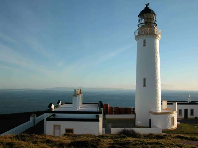
Rhins of Galloway, Dumfries and Galloway, Scotland · DG9 9HP
Guillemots, Razorbills and Kittiwakes on the cliffs at Scotland’s southern tip.

Decide if the visit fits.
Mull of Galloway at a glance
Last checked 18 October 2026.
- Open
- Outdoor reserve open 24 hours; separate indoor attraction hours apply.More about open
- Price / parking
- Reserve entry free; lighthouse attractions have separate charges.More about price / parking
- Best time
- Spring seabirds · autumn migration · winter coastMore about best time
- Dogs
- The Trust welcomes supervised dogs on leads around the site and…More about dogs
- Toilets
- Toilets are located at the RSPB visitor centre, with customer to…More about toilets
- Step-free
- The RSPB describes an uneven mixture of rolled stone, tarmac, bo…More about step-free
Opening and charges information · checked .
Stay nearby →On this page
Reserve overview
Reserve and habitat
Guillemots, Razorbills and Kittiwakes on the cliffs at Scotland’s southern tip.
Eight checks for a smoother visit.
Planning your visit
Conditions change: check the operator and transport notices before travelling.
Best time to visit and seasonal birds
January: typically look for Shag from Ramped viewpoint in lighthouse grounds. Watch only from the signed trail or operator’s viewpoints. Cliff-colony attendance and offshore passage vary each day; do not approach ledges or follow a Peregrine. February: typically look for Raven from Public high-point sea views around the reserve. Watch only from the signed trail or operator’s viewpoints. Cliff-colony attendance and offshore passage vary each day; do not approach ledges or follow a Peregrine. March: typically look for Guillemot from Foghorn viewing platform. Watch only from the signed trail or operator’s viewpoints. Cliff-colony attendance and offshore passage vary each day; do not approach ledges or follow a Peregrine. April: typically look for Razorbill from Foghorn viewing platform. Watch only from the signed trail or operator’s viewpoints. Cliff-colony attendance and offshore passage vary each day; do not approach ledges or follow a Peregrine. May: typically look for Kittiwake from Ramped viewpoint in lighthouse grounds. Watch only from the signed trail or operator’s viewpoints. Cliff-colony attendance and offshore passage vary each day; do not approach ledges or follow a Peregrine. June: typically look for Black Guillemot from Ramped viewpoint in lighthouse grounds. Watch only from the signed trail or operator’s viewpoints. Cliff-colony attendance and offshore passage vary each day; do not approach ledges or follow a Peregrine. July: typically look for Wheatear from Signed circular trail across heathland. Watch only from the signed trail or operator’s viewpoints. Cliff-colony attendance and offshore passage vary each day; do not approach ledges or follow a Peregrine. August: typically look for Manx Shearwater from Public high-point sea views around the reserve. Watch only from the signed trail or operator’s viewpoints. Cliff-colony attendance and offshore passage vary each day; do not approach ledges or follow a Peregrine. September: typically look for Manx Shearwater from Public high-point sea views around the reserve. Watch only from the signed trail or operator’s viewpoints. Cliff-colony attendance and offshore passage vary each day; do not approach ledges or follow a Peregrine. October: typically look for Stonechat from Signed circular trail across heathland. Watch only from the signed trail or operator’s viewpoints. Cliff-colony attendance and offshore passage vary each day; do not approach ledges or follow a Peregrine. November: typically look for Linnet from Signed circular trail across heathland. Watch only from the signed trail or operator’s viewpoints. Cliff-colony attendance and offshore passage vary each day; do not approach ledges or follow a Peregrine. December: typically look for Shag from Ramped viewpoint in lighthouse grounds. Watch only from the signed trail or operator’s viewpoints. Cliff-colony attendance and offshore passage vary each day; do not approach ledges or follow a Peregrine.
Best conditions: Usually choose a clear, calmer spell for studying the colony and a safe, stable viewpoint for offshore birds. An early-autumn sea watch can add Manx Shearwaters; strong winds may make cliff positions unsafe rather than simply improving the bird list. Use the ramped lighthouse-ground alternative when the steep foghorn route is unsuitable.
Opening times, entry and facilities
Reserve entry is free for adults and children, both members and non-members, according to the RSPB charges page checked 18 October 2026. The Mull of Galloway Trust confirms free day-visitor parking. The separate lighthouse tower and exhibition are run by the Trust, with their own visitor arrangements; the Trust currently describes tower entry by donation. An ordinary reserve visit does not automatically include access to these separate attractions or a guided event. Choose the cliff-viewing route that suits your group’s mobility and the weather, distinguishing the ramped lighthouse-ground view from the steep foghorn steps. Overnight motorhome parking is prohibited. Check current operator notices before travelling, particularly if indoor facilities are essential to your day.
Access times: Reserve: RSPB October 2026 calendar states outdoor nature reserve open 24 hours; safety closures and current signs apply. · Hides: No public enclosed hide network. Outdoor foghorn and lighthouse-ground views subject to weather. Indoor season conflicts: main page Easter–October; facilities page May–October. Confirm exact day’s hours. · Car park: RSPB states the main car park outside the wall is not locked and is unlit apart from lighthouse illumination. Overnight motorhomes are prohibited by site rules. · Dawn access: yes. Operator opening information.
Trails, hides and visit length
The RSPB’s core circular trail is approximately half a mile long, linking views around the heathland and cliffs. Its short distance should not encourage a rushed visit: seabird observation works best when you spend time at a position and learn the line that birds take towards the ledges. The lighthouse grounds and the foghorn-facing viewpoint give different perspectives, while the wider sea can hold feeding birds beyond the cliff colony. There is no conventional network of enclosed marsh hides here. Choose a view that lets you stand securely and use optics without leaning towards an edge. Two-hour plan, editorial suggestion: begin near the visitor starting point, identify the main ledges and watch one section for a sustained period. Follow the short signed circuit only as far as conditions comfortably allow, then finish with a separate scan offshore. If the breeding birds are feeding actively, devote more time to that first position instead of trying to reach every corner of the headland. Full-day plan, editorial suggestion: use the morning for the colony and a slow heathland circuit, take a food break, then return to the best viewing area when the light has changed. Add the Trust’s lighthouse or exhibition only if its own admission arrangements fit the day. A longer coastal walk should be treated as a separate undertaking with the appropriate route preparation, not an automatic extension of a short reserve loop. Keep children and equipment away from cliff edges, stay within signed visitor areas and leave birds space when they move through the low vegetation. Never descend towards a ledge to improve an angle; watching a sequence of natural behaviour from the designated route is the purpose of the visit.
Where to watch
Use the linked reserve map and directions with current access notices. Species are typical seasonal targets. Light and telescope advice reflects our choice of viewpoint.
Foghorn viewing platformWinter · Spring · Summer · Autumn
Seabird cliffs and open sea
Steep stairway; never descend beyond the public platform.
Winter: Shag, Raven, Peregrine
Spring: Guillemot, Razorbill, Kittiwake, Peregrine
Summer: Guillemot, Razorbill, Shag, Peregrine
Autumn: Manx Shearwater, Shag, Peregrine
Light: either. Scope: useful.
Ramped viewpoint in lighthouse groundsWinter · Spring · Summer · Autumn
Cliffs and offshore water from lighthouse grounds
Ramped viewing area, distinct from the steep foghorn steps.
Winter: Shag, Raven
Spring: Black Guillemot, Kittiwake
Summer: Guillemot, Razorbill, Kittiwake
Autumn: Manx Shearwater, Shag
Light: either. Scope: useful.
Signed circular trail across heathlandWinter · Spring · Summer · Autumn
Heathland and short grass beside the route
Uneven circular trail with stone, tarmac, boardwalk and grass.
Winter: Stonechat, Linnet
Spring: Wheatear, Linnet, Stonechat
Summer: Wheatear, Stonechat, Twite
Autumn: Wheatear, Stonechat
Light: either. Scope: not needed.
Public high-point sea views around the reserveWinter · Spring · Summer · Autumn
Irish Sea and distant Scar Rocks
Use secure public high points; no route or landing on Scar Rocks.
Winter: Shag, Raven
Spring: Gannet, Black Guillemot
Summer: Gannet, Manx Shearwater
Autumn: Manx Shearwater, Gannet
Light: either. Scope: essential.
| Spot | Overlooks | Key species by season | Best light | Scope | Tide |
|---|---|---|---|---|---|
| Foghorn viewing platformSteep stairway; never descend beyond the public platform. | Seabird cliffs and open sea | Winter: Shag, Raven, Peregrine Spring: Guillemot, Razorbill, Kittiwake, Peregrine Summer: Guillemot, Razorbill, Shag, Peregrine Autumn: Manx Shearwater, Shag, Peregrine | either | useful | — |
| Ramped viewpoint in lighthouse groundsRamped viewing area, distinct from the steep foghorn steps. | Cliffs and offshore water from lighthouse grounds | Winter: Shag, Raven Spring: Black Guillemot, Kittiwake Summer: Guillemot, Razorbill, Kittiwake Autumn: Manx Shearwater, Shag | either | useful | — |
| Signed circular trail across heathlandUneven circular trail with stone, tarmac, boardwalk and grass. | Heathland and short grass beside the route | Winter: Stonechat, Linnet Spring: Wheatear, Linnet, Stonechat Summer: Wheatear, Stonechat, Twite Autumn: Wheatear, Stonechat | either | not needed | — |
| Public high-point sea views around the reserveUse secure public high points; no route or landing on Scar Rocks. | Irish Sea and distant Scar Rocks | Winter: Shag, Raven Spring: Gannet, Black Guillemot Summer: Gannet, Manx Shearwater Autumn: Manx Shearwater, Gannet | either | essential | — |
Target species
Month chips show typical presence or our preferred viewing season. Choose birds that suit the time of your visit.
Headline birds
- MarAprMayJunJul
- MarAprMayJunJul
- MarAprMayJunJulAug
Regular birds
- JanFebMarAprMayJunJulAugSepOctNovDec
- JanFebMarAprMayJunJulAugSepOctNovDec
- JanFebMarAprMayJunJulAugSepOctNovDec
- MarAprMayJunJulAugSepOct
- Manx ShearwaterPublic high-point sea views around the reservePublic high-point sea views around the reserveAprMayJunJulAugSepOct
- MarAprMayJunJulAugSepOct
- JanFebMarAprMayJunJulAugSepOctNovDec
- JanFebMarAprMayJunJulAugSepOctNovDec
- JanFebMarAprMayJunJulAugSepOctNovDec
Scarce but regular birds
- AprMayJunJulAug
Tide planning
This is a clifftop reserve, with no tidal crossing to its ordinary viewpoints. Tide predictions provide context for offshore watching; wind, swell, visibility and secure footing take priority. Never descend cliffs or seek access to Scar Rocks at low water.
Seasonal wildlife spectacle
Season: Cliff seabirds in spring and early summer; offshore Manx Shearwater gatherings typically early autumn.. Arrival time: Use the official foghorn platform or ramped lighthouse-ground view during a safe daylight spell. Allow time for birds to return from fishing; no fixed daily arrival or feeding time is published.. Hotline: https://events.rspb.org.uk/. Ordinary free reserve viewing needs no event booking. Use the public car park and avoid crowding the platform; RSPB guided walks require their own current listing and booking. Lighthouse visits are separately managed.
Accessibility and step-free routes
The RSPB describes an uneven mixture of rolled stone, tarmac, boardwalk and grass on the reserve trail. The foghorn viewing platform is reached by a steep stairway; a different viewing area in the lighthouse grounds is reached by ramp. Choose between those destinations before setting off, rather than expecting identical access to both. The visitor centre itself has step-free entry, a single-level layout, manual doors and seating with backs. The operator also identifies Blue Badge parking and a drop-off point outside that building. An accessible toilet is provided at the visitor centre, with its key held there. The Trust identifies additional accessible parking at several locations and a wheelchair viewing platform overlooking the cliffs and foghorn. Explain your equipment and desired destination when making an access enquiry, particularly if a threshold, turning space or the return gradient determines whether the trip works. A lighthouse tower climb is a separate physical undertaking and should never be inferred from accessible grounds. Wind exposure adds effort even on a short route; allow a generous margin for returning after a stationary watch. The simpler viewpoint may deliver the most satisfying birdwatching if it lets you stay comfortable and concentrate.
Visitor facilities
Toilets are located at the RSPB visitor centre, with customer toilets at Gallie Craig coffee house. The latter provides the food-and-drink option beside the main parking area. The RSPB centre has two CCTV screens that provide another way to examine the seabird colony. A picnic table offers a place to pause outside. Bring layers and protection for optics, and keep bags secure when standing in the wind. Barbecues are not permitted on the reserve.
Dog rules
The Trust welcomes supervised dogs on leads around the site and in the exhibition and RSPB visitor centre, with outdoor café seating available; dogs cannot enter the lighthouse tower. The RSPB asks for short leads during 1 April–15 August and around livestock. Use the Trust’s lead rule throughout the shared visitor area and prevent any approach to cliff-nesting birds.
Public transport and getting there
Stranraer is the rail starting point identified by the RSPB, which describes the reserve as approximately 27 miles away. The official directions identify a bus connection to Drummore, still about five miles from the headland, and the Mull of Galloway Trail as a walking route beyond the village. A current end-to-end entrance bus timetable was not established in this check, so do not plan on a bus delivering you to the visitor centre. A pre-booked taxi from Stranraer is a more straightforward final connection for many visitors. If combining rail, village bus and a long walk, obtain the actual service times for your date and prepare the walking route separately; that final section is a substantial coastal outing, not a station-to-hide stroll. Confirm the return transfer and equipment space with a taxi operator before buying tightly timed rail tickets. The road beyond Drummore is single track: passing places must remain clear. Drivers should build in time to meet other traffic safely rather than treating an estimated drive time as a target to beat.
Useful bases for an early start.
Where to stay
Booking.com links are affiliate links: we may earn a commission at no extra cost to you. How these links work.
- 01
Drummore
About 5.2 miles by road, roughly 16 minutes’ drive from the measured central base point; OSRM/OpenStreetMap estimate measured 18 October 2026, excluding traffic, parking and walking.
Measured driving route · 2026-10-18. Map estimates exclude live traffic.
A local village base for an unhurried headland day.Find places to stay in Drummore on Booking.com - 02
Portpatrick
About 24.4 miles by road, roughly 42 minutes’ drive from the measured central base point; OSRM/OpenStreetMap estimate measured 18 October 2026, excluding traffic, parking and walking.
Measured driving route · 2026-10-18. Map estimates exclude live traffic.
A second Rhins coastal base for a longer birdwatching break.Find places to stay in Portpatrick on Booking.com - 03
Stranraer
About 21.7 miles by road, roughly 39 minutes’ drive from the measured central base point; OSRM/OpenStreetMap estimate measured 18 October 2026, excluding traffic, parking and walking.
Measured driving route · 2026-10-18. Map estimates exclude live traffic.
Rail connections, practical supplies and wider accommodation choice.Find places to stay in Stranraer on Booking.com
Explore Dumfries and Galloway’s full guides and smaller birding sites
Official sightings, safety and contact
The RSPB publishes 01776 840539 and mullofgalloway@rspb.org.uk. Ask the reserve about the visitor centre and birdwatching route, distinguishing those from the lighthouse tower. Trust enquiries go to info@mull-of-galloway.co.uk or 07442 115883. Specify the date, party size and access needs when discussing a group visit or an indoor attraction. Report a damaged path or disturbance concern with a clear location, without entering a risky area to investigate. Use the separate cottage operator for accommodation bookings and conditions.
Recent bird sightings
Check Dumfries and Galloway Bird News actual regional field reports. frequent dated regional reports; individual headland observations irregular Reports show what has been seen, not what will be.
- Dumfries and Galloway Bird News actual regional field reportsblog or social · updated frequent dated regional reports; individual headland observations irregular
- SOC 2026 spring arrivals by county recording areacounty club or recorder · updated completed seasonal table, data to 9 June 2026
Birding sources
- RSPB current species and seasonal information
- RSPB official viewpoint inventory and access
- RSPB live opening calendar
- RSPB entrance location map
- SOC 2026 actual spring bird observations
- Dumfries and Galloway Bird News actual dated reports
- Dumfries and Galloway September 2025 headland observation archive
- Mull of Galloway Trust access and drone restrictions
- UKHO EasyTide named prediction station
Follow the BTO Birders’ Code and give wildlife space.
Questions visitors ask
Is Mull of Galloway free to visit?
Mull of Galloway: Reserve entry free; lighthouse attractions have separate charges.
Can I take my dog to Mull of Galloway?
Mull of Galloway: The Trust welcomes supervised dogs on leads around the site and in the exhibition and RSPB visitor centre, with outdoor café seating available; dogs cannot enter the lighthouse tower.
When is the best time to visit Mull of Galloway?
Mull of Galloway: Spring seabirds · autumn migration · winter coast.
Is Mull of Galloway accessible for wheelchairs?
Mull of Galloway: The foghorn viewing platform is reached by a steep stairway; a different viewing area in the lighthouse grounds is reached by ramp.
How do I get to Mull of Galloway without a car?
Mull of Galloway: Stranraer is the rail starting point identified by the RSPB, which describes the reserve as approximately 27 miles away.
Best months for this reserve
Nearby complete guides.
Bird reserves
Stops with a purpose: use one as a contrasting habitat or weather-proof Plan B. Distances are straight-line estimates, not road journeys.
- About 23 miles away · A familiar habitatRSPB Crook of BaldoonWinter geese and swans · breeding waders in spring
- About 29 miles away · A useful habitat changeRSPB Wood of CreeMay–June woodland song; year-round walks and resident wildlife
- About 50 miles away · A useful habitat changeRSPB MerseheadAutumn and winter geese · spring breeding waders