
Short entry3.9 miles away
Killykeeghan National Nature Reserve
Marlbank Road, near Florencecourt · Limestone grassland and hazel scrub
 the ai birderBirding near me
The AI Birder · one-page field sheet
West of Kinawley, County Fermanagh, Northern Ireland · BT92 3BE · BT92 3BE

Current planning alert (2026-10-18): Geopark advice checked 18 October 2026: continuing beyond the Cuilcagh Boardwalk viewing platform towards the summit is not recommended. Stay on designated routes and within the platform.
Red Grouse · Meadow Pipit · Raven · Snipe
Gortalughany viewpoint and adjoining roadside · Waymarked Hiker’s Trail
Check current access, hide closures and operator notices before travelling. Seasonal birds are possibilities, not promised sightings. Keep to authorised routes and give wildlife space.
Opening and charges checked 2026-10-25. Operator: https://www.rspb.org.uk/days-out/reserves/aghatirourke
Full guide and current source links: https://aibirder.co.uk/reserves/rspb-aghatirourke
NI 09 · RSPB reserve guide
West of Kinawley, County Fermanagh, Northern Ireland · BT92 3BE
Red Grouse, Skylarks, Meadow Pipits and Wheatears use the open uplands, Sand Martins return in spring, and summer can bring Hen Harriers or Peregrines over one of Northern Ireland's most important blanket-bog landscapes.
Decide if the visit fits.
Last checked 18 October 2026.
Geopark advice checked 18 October 2026: continuing beyond the Cuilcagh Boardwalk viewing platform towards the summit is not recommended. Stay on designated routes and within the platform.
Opening and charges information · checked .
Stay nearby →Reserve overview
Red Grouse, Skylarks, Meadow Pipits and Wheatears use the open uplands, Sand Martins return in spring, and summer can bring Hen Harriers or Peregrines over one of Northern Ireland's most important blanket-bog landscapes.
Eight checks for a smoother visit.
Conditions change: check the operator and transport notices before travelling.
January: typically look for Raven from Gortalughany viewpoint and adjoining roadside. Poor visibility or ice is a reason to stay low or cancel. February: typically look for Red Grouse from Waymarked Hiker’s Trail. Only attempt a suitable open route with winter hill skills. March: typically look and listen for Skylark, Meadow Pipit and Snipe from Waymarked Hiker’s Trail. The RSPB’s archived May 2023 guide records Snipe along its nature trail; stay on the waymarkers and never approach or deliberately flush a bird. April: typically look for Wheatear from Waymarked Hiker’s Trail. Never investigate peat-bank nests. May: typically look for Cuckoo and Sand Martin from Gortalughany viewpoint and adjoining roadside. Watch open sky and listen without leaving the public approach. June: typically look for Skylark and Meadow Pipit from Waymarked Hiker’s Trail. Keep away from sensitive breeding habitat. July: typically look for Red Grouse from Waymarked Hiker’s Trail. Choose a dry, clear forecast rather than a summit objective. August: typically look for Raven from Gortalughany viewpoint and adjoining roadside. An August 2014 local report confirms occurrence, not a promised flock. September: typically look for Wheatear from Waymarked Hiker’s Trail. Passage varies and weather can turn quickly. October: typically look for Red Grouse from Waymarked Hiker’s Trail. Shortening daylight limits route choice. November: typically look for Raven from Gortalughany viewpoint and adjoining roadside. Use the lower viewpoint if safe to travel. December: typically look for Raven from Gortalughany viewpoint and adjoining roadside. Do not use bird targets to justify a dangerous upland walk.
Best conditions: Our choice is a clear, dry, relatively still day, with generous daylight and an easy option to turn back. Fog, strong wind, ice or saturated ground can make a birding walk unsuitable. Scope from the lower viewpoint if helpful, but binoculars are more practical on the steep trail. No off-trail exploration: limestone swallow holes are unmarked.
2026 admission checked on 18 October: the RSPB's charges table lists adults, children and parking free for both members and non-members. Its opening page describes reserve access as dawn to dusk. Choose daylight that covers the whole visit and the return down the approach road, particularly in winter. No timed ticket is required for an ordinary visit. Parking is at the Gortalughany viewpoint, the signed arrival point identified by the RSPB. Keep access clear for other vehicles and farm activity, and do not improvise parking on the narrowing approach. Check current RSPB and Geopark access advice together with a mountain forecast before travelling. Conditions can change quickly on this exposed upland site.
Access times: Reserve: RSPB calendar lists dawn–dusk. Weather and route restrictions override access. · Hides: No enclosed hide; official roadside/viewpoint and waymarked trail only. · Car park: Gortalughany viewpoint parking listed; no independent gate timetable verified. No lighting. · Dawn access: partly. Operator opening information.
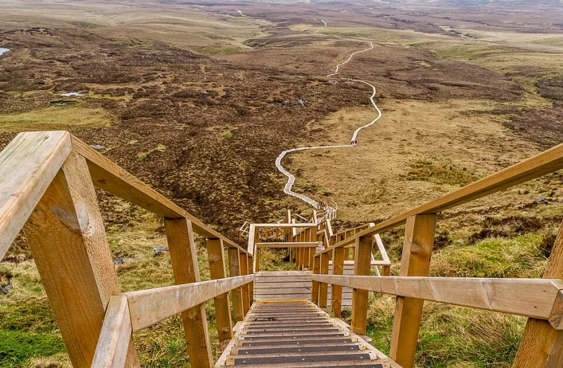
Aghatirourke offers open-country watching rather than a circuit between hides. The RSPB identifies the roadside and track next to Gortalughany car park as places to appreciate the landscape and some wildlife. This makes a shorter visit possible without committing to a mountain route. Begin by listening and scanning across vegetation changes: bog, grassland and exposed higher ground support different activity. The waymarked Hiker's Trail is an unsurfaced route identified by marker posts. The RSPB advises at least two-and-a-half hours for its reserve walk and says the route is suitable only for experienced hillwalkers able to navigate exposed uplands. The Geopark's wider description gives a difficult linear trail of about nine kilometres and a four-hour return. Neither walking estimate includes long birdwatching stops or a slow retreat in deteriorating conditions. Two-hour plan: remain around the authorised roadside and adjacent track views. Spend the first half-hour identifying the different slopes and listening for song or grouse calls. Choose one safe observation position for a longer watch, scanning the skyline for raptors and the nearer ground for small birds. If making a short trail excursion, turn back early enough to avoid compressing the return. This editorial plan is a viewpoint visit, not a shortened promise of the summit route. Full-day plan: experienced, properly equipped walkers can devote a suitable-weather day to an allowed section of the waymarked route, adding slow observation stops. Agree a turnaround time before leaving the car park and reassess visibility and wind as you go. A long day does not require reaching the highest ground; repeated watches from a safe lower position can provide better birding than pushing on into cloud. Stay on the marked route. The RSPB prohibits off-trail access because unmarked swallow holes occur above the underlying limestone cave system. Do not step into apparently inviting vegetation to obtain a photograph or approach a bird. The route and conservation instructions determine where a watch is possible.
Use the linked reserve map and directions with current access notices. Species are typical seasonal targets. Light and telescope advice reflects our choice of viewpoint.
Open limestone grassland, bog and mountain skyline
Use the official viewpoint and adjoining public track; do not enter unmarked ground.
Winter: Raven
Spring: Sand Martin, Raven
Summer: Sand Martin, Raven
Autumn: Sand Martin, Raven
Light: either. Scope: useful.
Blanket bog, grassland and open upland skyline
Experienced hillwalkers only; wet, steep and slippery. No off-trail access: swallow holes. Do not extend into a closed or discouraged summit route.
Winter: Red Grouse, Snipe
Spring: Red Grouse, Skylark, Wheatear, Meadow Pipit, Cuckoo, Snipe
Summer: Red Grouse, Skylark, Wheatear, Meadow Pipit, Cuckoo
Autumn: Red Grouse, Skylark, Wheatear, Meadow Pipit, Snipe
Light: either. Scope: not needed.
| Spot | Overlooks | Key species by season | Best light | Scope | Tide |
|---|---|---|---|---|---|
| Gortalughany viewpoint and adjoining roadsideUse the official viewpoint and adjoining public track; do not enter unmarked ground. | Open limestone grassland, bog and mountain skyline | Winter: Raven Spring: Sand Martin, Raven Summer: Sand Martin, Raven Autumn: Sand Martin, Raven | either | useful | — |
| Waymarked Hiker’s TrailExperienced hillwalkers only; wet, steep and slippery. No off-trail access: swallow holes. Do not extend into a closed or discouraged summit route. | Blanket bog, grassland and open upland skyline | Winter: Red Grouse, Snipe Spring: Red Grouse, Skylark, Wheatear, Meadow Pipit, Cuckoo, Snipe Summer: Red Grouse, Skylark, Wheatear, Meadow Pipit, Cuckoo Autumn: Red Grouse, Skylark, Wheatear, Meadow Pipit, Snipe | either | not needed | — |
Month chips show typical presence or our preferred viewing season. Choose birds that suit the time of your visit.
The full Hiker's Trail is not a wheelchair or pushchair route. The RSPB describes uneven ground that can be very wet and slippery, with steep sections, a narrow bridge and no seating. These features matter independently: even a visitor comfortable with distance may find a slippery traverse or constrained crossing unsuitable. The Geopark also identifies a rock scramble on its mountain itinerary. A more limited visit can use the roadside and track beside the viewpoint, which the RSPB specifically identifies for landscape and wildlife watching. Assess the actual stopping place and the space needed to leave a vehicle before unloading a mobility aid. Do not assume that a short section of track represents the conditions farther uphill. There are no accessible toilets on the reserve; the operator directs visitors to Enniskillen, around thirteen miles away, for facilities. Plan personal-care needs before leaving town. Contact the RSPB about the precise arrival point and any essential access requirement. Describe your equipment and desired viewing distance so the advice concerns a specific visit rather than an overall accessibility label. A stationary vehicle-based scan may be the best option for some visitors when the lawful parking position and view align.
There is no visitor centre, resident staff, café or shop. Bring food, drinking water and spare clothing for the whole planned outing; the RSPB identifies Enniskillen as the nearest place for refreshments. The car park has no lighting. Pack a map, compass, waterproofs and the equipment appropriate to an exposed hill route, with a charged phone as an additional aid rather than the only navigation method. Barbecues are prohibited because of fire risk to people and habitat.
Pet dogs are not permitted in Cuilcagh Mountain Park under the Geopark's rules. The RSPB welcomes assistance dogs. Confirm any essential assistance-dog arrangements with the team before a long journey, particularly if a difficult trail section is intended. Respect the restriction when choosing other walks for a group travelling with a pet.
The RSPB describes a bus connection from Enniskillen towards Swanlinbar and advises requesting the Gortalughany tourist-sign stop, approximately three miles from the reserve gate. Translink's route-search service and current open timetable data identify the Enniskillen–Swanlinbar service as 192, with a related 192a service. Check the actual stopping pattern and return before relying on that rural connection; the remaining climb is substantial. For a car-free birding visit, a prearranged taxi from Enniskillen to Gortalughany viewpoint is the more direct option. Reserve the return pickup and explain the exact viewpoint, since the popular Cuilcagh Boardwalk has a different approach. Do not finish a difficult upland walk expecting an unbooked rural taxi to appear immediately. Drivers follow the A4 Sligo Road west from Enniskillen and then the A32 south. The RSPB says to ignore the Florencecourt and Marble Arch Caves visitor signs and take the turn signed Gortalughany viewpoint. Follow the narrowing road carefully. Regional cycle routes pass on minor roads north and east of the reserve, with a separate rural approach still required.
Useful bases for an early start.
Booking.com links are affiliate links: we may earn a commission at no extra cost to you. How these links work.
About 12.9 miles by road, roughly 20 minutes’ drive from the mapped town-centre point to Gortalughany viewpoint. OpenStreetMap estimate for Enniskillen, measured 18 October 2026. For the Enniskillen journey linked to RSPB Aghatirourke, leave additional time for traffic and reaching your precise accommodation address.
Measured driving route · 2026-10-18. Map estimates exclude live traffic.
Bus arrivals and services before a rural hill visit.Find places to stay in Enniskillen on Booking.comAbout 6.9 miles by road, roughly 10 minutes’ drive from the mapped town-centre point to Gortalughany viewpoint. OpenStreetMap estimate for Florencecourt, measured 18 October 2026. For the Florencecourt journey linked to RSPB Aghatirourke, leave additional time for traffic and reaching your precise accommodation address.
Measured driving route · 2026-10-18. Map estimates exclude live traffic.
Combining the upland reserve with the wider Geopark area.Find places to stay in Florencecourt on Booking.comAbout 13.8 miles by road, roughly 20 minutes’ drive from the mapped town-centre point to Gortalughany viewpoint. OpenStreetMap estimate for Belcoo, measured 18 October 2026. For the Belcoo journey linked to RSPB Aghatirourke, leave additional time for traffic and reaching your precise accommodation address.
Measured driving route · 2026-10-18. Map estimates exclude live traffic.
A village base near the Fermanagh–Cavan border.Find places to stay in Belcoo on Booking.comExplore County Fermanagh’s full guides and smaller birding sites
The RSPB contact is 028 6632 3991 or lower.lougherne@rspb.org.uk. Give Aghatirourke and Gortalughany viewpoint when asking about visitor access. The Cuilcagh Lakelands Geopark provides separate route and mountain advice at cuilcaghlakelands.org. Tell someone your intended route and return time before a hill outing. In an emergency call 999 or 112 and request Mountain Rescue. For ordinary planning questions, use the operator's contact rather than relying on a report from a different Cuilcagh trail.
Check Northern Ireland regional bird sightings. usually daily regional reports; Aghatirourke reports infrequent Reports show what has been seen, not what will be.
Follow the BTO Birders’ Code and give wildlife space.
RSPB Aghatirourke: Free entry and parking.
RSPB Aghatirourke: Pet dogs are not permitted in Cuilcagh Mountain Park under the Geopark's rules.
RSPB Aghatirourke: Spring upland birds · summer raptors · quiet autumn and winter.
RSPB Aghatirourke: The full Hiker's Trail is not a wheelchair or pushchair route.
RSPB Aghatirourke: The RSPB describes a bus connection from Enniskillen towards Swanlinbar and advises requesting the Gortalughany tourist-sign stop, approximately three miles from the reserve gate.
Shorter stops within 15 miles in a straight line. Use the operator’s arrival directions for the journey.
Marlbank Road, near Florencecourt · Limestone grassland and hazel scrub
Upper Lough Erne, near Newtownbutler · Ancient woodland, wet grassland, parkland and freshwater lough shore
Nearby complete guides.
Stops with a purpose: use one as a contrasting habitat or weather-proof Plan B. Distances are straight-line estimates, not road journeys.