
Short entry10.9 miles away
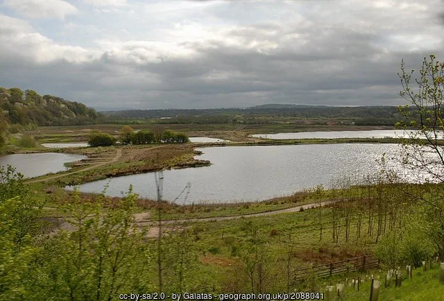
Hesketh Out Marsh
Hesketh Bank · Saltmarsh, lagoons and estuary
 the ai birderBirding near me
The AI Birder · one-page field sheet
Preston, Lancashire, England · PR5 0AG · PR5 0AG

Lapwing · Reed Bunting · Kestrel · Song Thrush · Buzzard · Goldeneye
The Lookout Hide · Number 1 Pit western bird hide · Meadow Lake northern bird hide · Meadow Lake public path · Boilton Wood footpath · River Ribble public path
Check current access, hide closures and operator notices before travelling. Seasonal birds are possibilities, not promised sightings. Keep to authorised routes and give wildlife space.
Opening and charges checked 2026-10-18. Operator: https://www.lancswt.org.uk/nature-reserves/brockholes-nature-reserve
Full guide and current source links: https://aibirder.co.uk/reserves/brockholes-nature-reserve
EN 44 · Lancashire Wildlife Trust reserve guide
Preston, Lancashire, England · PR5 0AG
Lapwing, Oystercatcher, Redshank, Whimbrel
Decide if the visit fits.
Last checked 18 October 2026.
Opening and charges information · checked .
Stay nearby →Reserve overview
Lapwing, Oystercatcher, Redshank, Whimbrel
Eight checks for a smoother visit.
Conditions change: check the operator and transport notices before travelling.
January: use The Lookout Hide and Meadow Lake northern bird hide for Lapwing and a patient Bittern possibility. The River Ribble public path gives a separate Goldeneye watch if conditions are safe. February: Boilton Wood footpath usually adds Song Thrush and Buzzard activity to the lake visit. Meadow Lake northern bird hide remains a sheltered option for Lapwing and concealed Bittern. March: Oystercatcher, Lapwing and Redshank give The Lookout Hide and Number 1 Pit western bird hide a spring focus. Keep island birds undisturbed rather than searching for their nests. April: Reed Bunting and returning Sedge Warbler can make Meadow Lake public path worthwhile. Compare The Lookout Hide for Ringed Plover and Oystercatcher on suitable open margins. May: scan from Meadow Lake public path for Swift and Hobby, then settle at a hide for Lapwing and Redshank. Whimbrel are a seasonal attraction, but their resting area is not published here. June: Sedge Warbler and Reed Bunting remain useful along Meadow Lake public path. The Lookout Hide provides a lake watch for Lapwing and Oystercatcher without entering restricted habitat. July: Number 1 Pit western bird hide usually offers the better place to compare lake birds with aerial Swift and Hobby activity. In warm weather, a woodland break on Boilton Wood footpath can be more comfortable than continuous exposed watching. August: give Meadow Lake public path time for Hobby and Reed Bunting, with Redshank and Lapwing from the northern bird hide. Muddy island availability changes, so compare more than one public view. September: The Lookout Hide and Meadow Lake northern bird hide usually reward a careful Lapwing and wader scan. Kestrel and late Hobby activity can add interest from the public lake path. October: a shorter loop between The Lookout Hide and Meadow Lake public path suits Lapwing, Kestrel and Reed Bunting. Use the operator’s current gate advice before extending the session into evening. November: choose a sheltered Meadow Lake northern bird hide watch for Lapwing and possible Bittern. Boilton Wood footpath provides a different Song Thrush and Buzzard session if river paths are wet. December: The Lookout Hide offers a compact winter Lapwing watch. In a safe, clear spell the River Ribble public path can add Goldeneye; flooding is a reason to shorten the route, not to improvise a waterside detour.
Best conditions: Usually choose calmer weather for scope work across the lakes and use a hide during rain. Flooding can affect river paths, while glare may favour changing viewing position rather than walking closer to a bird. Light and scope ratings are editorial, based on the public map; no weather guarantees a passage bird.
Checked on 18 October 2026: entry is free and an ordinary day visit needs no booking. Parking is £6 for the day, including Blue Badge vehicles. The Trust’s ANPR system records arrival and departure; payment machines take coins, card, Apple Pay and Google Pay, and RingGo uses location 25806. There is a strict ten-minute grace period for taxis and drop-offs, after which the full charge applies. Opening hours and the conflicting evening gate times are set out in Access times. Use the earlier published finish unless the operator confirms otherwise. The main café operates at weekends and during Lancashire school holidays, while the Welcome Centre serves drinks and snacks. Check current operator notices before travelling, including flood conditions or route changes, and allow time to reach your vehicle before the confirmed gate closes.
Access times: Reserve: Outdoor daytime visiting; check flood and management notices. Visitor Village and Welcome Centre 10:00–16:00 daily. · Hides: A separate public hide-door timetable was not found. Do not assume shop or Visitor Village hours establish every outdoor hide’s hours. · Car park: Operator pages conflict: reserve listing 06:00–19:00; opening-hours page 06:00–21:00. Plan within the shorter window and confirm before relying on an evening exit. · Dawn access: partly. Operator opening information.
Build your route around Meadow Lake and Number 1 Pit, then decide whether to continue through Boilton Wood or beside the River Ribble. The Trust’s current reserve map shows these areas and the links between them. The variety is the attraction: a lake viewpoint rewards slow scanning, woodland encourages listening, and meadow edges add insects and other wildlife to the day. Use the signed paths and gates rather than assuming the shortest line between water bodies is public access. The Lookout overlooks Number 1 Pit and also houses the in focus optics shop. Other bird hides and viewing points offer places to stop around the reserve. Choose your angle according to wind and light, leaving room for visitors who want to watch from a seated position. Cattle may be grazing; give animals space and close gates behind you. The lakes are for wildlife watching, not fishing or feeding birds. Two-hour plan — our suggestion: start with the closest Meadow Lake view from the Visitor Village, then make a measured excursion towards Number 1 Pit and The Lookout. Spend at least as much time watching as walking. If a flock is feeding well, stay with it rather than trying to complete a larger circuit. Full-day plan — our recommendation: watch the lakes during the morning, pause for lunch, then add a woodland or riverside route from the current map. Return to Meadow Lake for a final watch so you can compare the feeding activity with your first session. In wet conditions shorten the walk and favour the surfaced paths. The reserve occupies a floodplain, so shoes suitable for soft ground are sensible even after a dry start. Carry binoculars, a drink and a layer for a long stationary spell beside open water.
Use the linked reserve map and directions with current access notices. Species are typical seasonal targets. Light and telescope advice reflects our choice of viewpoint.
Number 1 Pit, open water and muddy islands
Use the signed approach; optics shop opening is separate from general outdoor access.
Winter: Lapwing, Bittern
Spring: Lapwing, Oystercatcher, Redshank, Sand Martin
Summer: Lapwing, Swift, Hobby, Sand Martin
Autumn: Lapwing, Kestrel, Sand Martin
Light: either. Scope: useful.
Number 1 Pit lake and wet margins
Descriptive location for the unnamed Bird Hide shown on the official map, not a newly invented hide name.
Winter: Lapwing, Bittern
Spring: Oystercatcher, Ringed Plover
Summer: Swift, Hobby
Autumn: Lapwing, Kestrel
Light: either. Scope: useful.
Meadow Lake and reed-fringed islands
Descriptive location for the second unnamed Bird Hide on the official map.
Winter: Lapwing, Bittern
Spring: Lapwing, Redshank
Summer: Sedge Warbler, Reed Bunting
Autumn: Lapwing, Kestrel
Light: either. Scope: useful.
Lake margins, reeds and open sky
Keep to surfaced public routes; Boilton Marsh and East Meadow have restricted access.
Winter: Kestrel, Lapwing
Spring: Redshank, Reed Bunting
Summer: Swift, Hobby, Sedge Warbler
Autumn: Lapwing, Kestrel
Light: either. Scope: useful.
Woodland along the public trail
Stay on the public path and outside restricted themed-woodland areas.
Winter: Song Thrush, Buzzard
Spring: Song Thrush, Buzzard
Summer: Buzzard
Autumn: Song Thrush, Buzzard
Light: either. Scope: not needed.
Freshwater river and open sky beside the reserve
Use the mapped river path and check flood conditions.
Winter: Goldeneye
Spring: Goldeneye, Redshank
Summer: Swift
Autumn: Kestrel
Light: either. Scope: useful.
| Spot | Overlooks | Key species by season | Best light | Scope | Tide |
|---|---|---|---|---|---|
| The Lookout HideUse the signed approach; optics shop opening is separate from general outdoor access. | Number 1 Pit, open water and muddy islands | Winter: Lapwing, Bittern Spring: Lapwing, Oystercatcher, Redshank, Sand Martin Summer: Lapwing, Swift, Hobby, Sand Martin Autumn: Lapwing, Kestrel, Sand Martin | either | useful | — |
| Number 1 Pit western bird hideDescriptive location for the unnamed Bird Hide shown on the official map, not a newly invented hide name. | Number 1 Pit lake and wet margins | Winter: Lapwing, Bittern Spring: Oystercatcher, Ringed Plover Summer: Swift, Hobby Autumn: Lapwing, Kestrel | either | useful | — |
| Meadow Lake northern bird hideDescriptive location for the second unnamed Bird Hide on the official map. | Meadow Lake and reed-fringed islands | Winter: Lapwing, Bittern Spring: Lapwing, Redshank Summer: Sedge Warbler, Reed Bunting Autumn: Lapwing, Kestrel | either | useful | — |
| Meadow Lake public pathKeep to surfaced public routes; Boilton Marsh and East Meadow have restricted access. | Lake margins, reeds and open sky | Winter: Kestrel, Lapwing Spring: Redshank, Reed Bunting Summer: Swift, Hobby, Sedge Warbler Autumn: Lapwing, Kestrel | either | useful | — |
| Boilton Wood footpathStay on the public path and outside restricted themed-woodland areas. | Woodland along the public trail | Winter: Song Thrush, Buzzard Spring: Song Thrush, Buzzard Summer: Buzzard Autumn: Song Thrush, Buzzard | either | not needed | — |
| River Ribble public pathUse the mapped river path and check flood conditions. | Freshwater river and open sky beside the reserve | Winter: Goldeneye Spring: Goldeneye, Redshank Summer: Swift Autumn: Kestrel | either | useful | — |
Month chips show typical presence or our preferred viewing season. Choose birds that suit the time of your visit.
The Wildlife Trust describes most footpaths as level and surfaced, with accessible hides and facilities around the Visitor Village. Kissing gates accommodate smaller wheelchairs and pushchairs; larger mobility vehicles can use neighbouring vehicle gates on surfaced routes. A key is available from the Welcome Centre for a £10 refundable deposit, so arrange this before taking a route where the ordinary gate may be too narrow. Sixteen designated parking spaces are listed for disabled visitors, around 125m from the Visitor Village. Adapted toilets are on the village; there are none out on the reserve. Plan comfort stops before setting off towards the woodland or river. Some paths are prone to wet conditions because the reserve is on a floodplain, and a level path can still be tiring when soft or muddy. Contact the team with your equipment’s size and your intended route if you need help choosing gates and surfaces. The mapped lake circuit and a longer woodland outing should be assessed separately. Keep enough energy for the return journey and identify a suitable turning point before leaving the village. Accessible facilities support a visit, but the most appropriate distance still depends on your own needs and the day’s ground conditions.
The floating Visitor Village contains the Welcome Centre, shop, refreshments, toilets and baby-changing provision, with a play area and picnic tables for families. The Kestrel Kitchen provides the main café option, while the optics shop at The Lookout lets visitors explore binoculars and telescopes. Bring a picnic if that suits your day and clear away all leftovers. The Trust asks visitors not to feed birds, because encouraging larger gulls around food can increase the risk to chicks nesting on the reserve.
Brockholes does not permit pet dogs. Assistance dogs are welcome on the reserve and in the Visitor Village. Arrange a different outing for a pet dog before travelling; leaving it at home also avoids disturbance to the grazing cattle and sensitive wildlife identified in the Trust’s visitor guidance.
Stagecoach service 59 links Preston with Blackburn and Accrington via the Tickled Trout stop at Samlesbury; the current Lancashire County Council timetable confirms that stop. From there, follow the Wildlife Trust’s published walking directions or step-by-step video to Brockholes using public footpaths. The Trust warns that the motorway junction itself has no safe pedestrian access: do not follow the signed vehicle entrance through the M6 roundabout on foot. Preston is the useful rail gateway, with an onward connection to the town’s bus station or a pre-booked taxi. Build time for the walk from the stop into both parts of the journey, and check the service-day column before setting out. The Guild Wheel cycle route runs through Brockholes, providing a further car-free approach. Drivers should use the Trust’s directions from M6 junction 31 and postcode PR5 0AG. The signed reserve access doubles back under the slip-road bridge; follow it carefully instead of making an unsafe turn when a satnav announces the destination.
Useful bases for an early start.
Booking.com links are affiliate links: we may earn a commission at no extra cost to you. How these links work.
About 3.8 miles by road, roughly 9 minutes’ drive from the town-centre map point (OSRM estimate measured 18 October 2026, without live traffic).
Measured driving route · 18 October 2026. Map estimates exclude live traffic.
Preston is the closest of these three town bases for Brockholes Nature Reserve.Find places to stay in Preston on Booking.comAbout 15.2 miles by road, roughly 23 minutes’ drive from the town-centre map point (OSRM estimate measured 18 October 2026, without live traffic).
Measured driving route · 18 October 2026. Map estimates exclude live traffic.
A base in Clitheroe suits a longer break that includes Brockholes Nature Reserve.Find places to stay in Clitheroe on Booking.comAbout 9.8 miles by road, roughly 15 minutes’ drive from the town-centre map point (OSRM estimate measured 18 October 2026, without live traffic).
Measured driving route · 18 October 2026. Map estimates exclude live traffic.
A base in Chorley suits a longer break that includes Brockholes Nature Reserve.Find places to stay in Chorley on Booking.comExplore Lancashire’s full guides and smaller birding sites
Contact Brockholes at brockholes@lancswt.org.uk or 01772 872000. Explain your date, group size and any specific access support needed, especially for larger mobility equipment or a planned visit outside the Visitor Village’s normal day. Organised groups should book coach parking directly because space is limited. Use the Trust’s event listings for guided walks and family activities, which may require separate booking. The official visitor postcode is PR5 0AG; make sure your search refers to Brockholes near Preston, not Brockhole in the Lake District.
Check Lancashire Wildlife Trust Brockholes wildlife observations, February 2021. historical dated roundup; not a current live feed Reports show what has been seen, not what will be.
Follow the BTO Birders’ Code and give wildlife space.
Brockholes Nature Reserve: Free entry; parking £6/day, including Blue Badge vehicles.
Brockholes Nature Reserve: Brockholes does not permit pet dogs.
Brockholes Nature Reserve: Spring breeding waders, summer aerial hunters and winter wetland birds.
Brockholes Nature Reserve: The Wildlife Trust describes most footpaths as level and surfaced, with accessible hides and facilities around the Visitor Village.
Brockholes Nature Reserve: Stagecoach service 59 links Preston with Blackburn and Accrington via the Tickled Trout stop at Samlesbury; the current Lancashire County Council timetable confirms that stop.
Shorter stops within 15 miles in a straight line. Use the operator’s arrival directions for the journey.
Hesketh Bank · Saltmarsh, lagoons and estuary
Holmeswood Road, near Rufford · Lakes · reedbed · woodland · wet meadow
Nearby complete guides.
Stops with a purpose: use one as a contrasting habitat or weather-proof Plan B. Distances are straight-line estimates, not road journeys.