Short entry3.7 miles away
Cwm Clettwr
Tre’r-ddôl · Broadleaved woodland, stream and heath pockets
 the ai birderBirding near me
The AI Birder · one-page field sheet
Ynyslas, Borth, Ceredigion, Wales · SY24 5JZ · SY24 5JZ

Current planning alert (2026-10-09): Ynyslas beach parking floods at high tide: move your car before the time shown at the entrance. Swimming, inflatables and boat launching are prohibited; the visitor centre is unstaffed.
Sanderling · Dunlin · Linnet · Stonechat · Ringed Plover · Golden Plover
Dune Walk public dunes · Dune Walk seashore · Ynyslas Walk saltmarsh edge · North Point public beach edge
Check current access, hide closures and operator notices before travelling. Seasonal birds are possibilities, not promised sightings. Keep to authorised routes and give wildlife space.
Opening and charges checked 2026-10-25. Operator: https://naturalresources.wales/days-out/places-to-visit/mid-wales/dyfi-national-nature-reserve-ynyslas/?lang=en
Full guide and current source links: https://aibirder.co.uk/reserves/dyfi-national-nature-reserve-ynyslas
WA 14 · Natural Resources Wales reserve guide
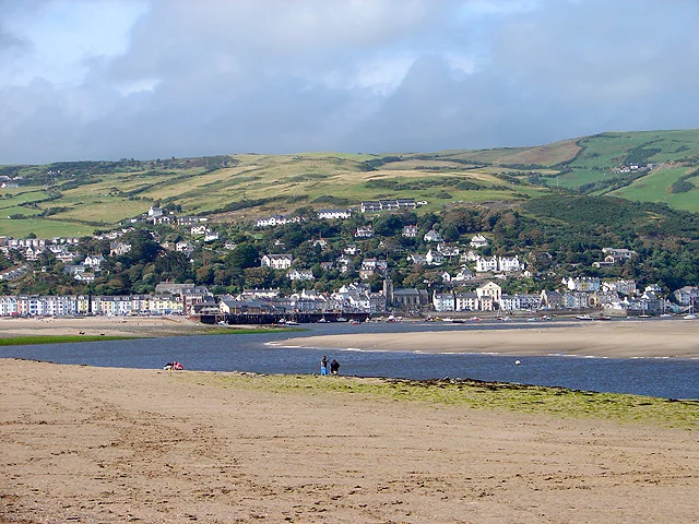
Ynyslas, Borth, Ceredigion, Wales · SY24 5JZ
The seaward gateway to the 2,000-hectare Dyfi National Nature Reserve, where Ceredigion's largest dunes meet internationally important estuary mudflats, sandbanks and saltmarsh. Autumn brings migrating waders; winter adds Sanderlings, Golden Plovers, wildfowl and hunting Hen Harriers, Merlins and Peregrines; spring and summer bring Skylarks, Linnets, warblers, Nightjars and occasional Ospreys over the estuary.
Decide if the visit fits.
Last checked 18 October 2026.
Ynyslas beach parking floods at high tide: move your car before the time shown at the entrance. Swimming, inflatables and boat launching are prohibited; the visitor centre is unstaffed.
Opening and charges information · checked .
Stay nearby →Reserve overview
The seaward gateway to the 2,000-hectare Dyfi National Nature Reserve, where Ceredigion's largest dunes meet internationally important estuary mudflats, sandbanks and saltmarsh. Autumn brings migrating waders; winter adds Sanderlings, Golden Plovers, wildfowl and hunting Hen Harriers, Merlins and Peregrines; spring and summer bring Skylarks, Linnets, warblers, Nightjars and occasional Ospreys over the estuary.
Eight checks for a smoother visit.
Conditions change: check the operator and transport notices before travelling.
January: typically look for Sanderling from Dune Walk seashore. Read the beach-parking flood notice. February: typically look for Golden Plover and Lapwing from Ynyslas Walk saltmarsh edge. Scope from the path. March: typically look for Skylark from Dune Walk public dunes. Breeding enclosures are not public watching routes. April: typically look for Ringed Plover and Dunlin from North Point public beach edge. Watch feeding birds without advancing on them. May: typically look for Shelduck from Ynyslas Walk saltmarsh edge. Passage and water level change the view. June: typically look for Linnet and Stonechat from Dune Walk public dunes. Stay outside roped areas. July: typically look for Oystercatcher from Dune Walk seashore. Keep well clear of settled birds. August: typically look for Ringed Plover and Dunlin from North Point public beach edge. Check the tide and return route. September: typically look for Curlew and Redshank from Ynyslas Walk saltmarsh edge. Use the marked saltmarsh edge only. October: typically look for Grey Plover from North Point public beach edge. Avoid a high-water crowding approach. November: typically look for Golden Plover and Lapwing from Ynyslas Walk saltmarsh edge. The beach car park can flood. December: typically look for Sanderling and Turnstone from Dune Walk seashore. Wind and surf can make shore watching difficult.
Best conditions: Choose lighter winds and a tide that leaves a safe shore and return route. The operator leaflet describes rising/high water bringing waders together, but this never overrides the beach car-park flood period. Scope feeding birds from the public edge and stop before they become alert.
2026 parking checked on 18 October: £4 per day or £40 for an annual season ticket. Blue Badge holders park free, and qualifying local residents can obtain a parking pass. NRW takes cash or card through the attendant. Parking overnight is not permitted at Dyfi National Nature Reserve - Ynyslas. The reserve and walking trails are open throughout the year; car-park access depends on the tide. The beach car park floods frequently. Read its displayed daily flooding periods before parking and move the vehicle out before the stated time. Ynyslas is a red-flag beach: swimming, inflatables and boat launching are prohibited because of strong currents. Do not dig in the dunes or light fires or barbecues. Leave suspicious shells or other objects untouched and report them to the coastguard through 999. Check NRW's current notices, tide and weather before travelling.
Access times: Reserve: Reserve and waymarked trails open all year, subject to signs, tide and temporary closures. · Hides: No enclosed public hide is mapped for the Ynyslas routes; watching is from open paths and shore. · Car park: Open all year but frequently flooded at high tide. Move before the entrance sign’s stated flood period; no overnight parking. A separate daily gate timetable is not published. · Dawn access: partly. Operator opening information.
Two waymarked circular routes introduce different parts of Ynyslas. The Dune Walk is 2.1 kilometres, with an operator walking estimate of thirty minutes to one hour. It crosses the changing dunes and reaches the seashore. The longer Ynyslas Walk is 4.3 kilometres, with an estimate of one-and-a-quarter to two hours, adding farmland and saltmarsh to the dune and beach habitats. Both are graded easy, but allow additional time for birdwatching and exposed coastal conditions. There are no hide stops to structure the day. Choose permitted viewpoints along the signed routes and settle long enough to understand the flock in front of you. Look across the whole feeding area before using a telescope on individual birds. A line of birds walking steadily away or an increasingly alert roost is a reason to give more room, not to continue following. Two-hour plan: use the Dune Walk as the framework, stopping to listen in open dune habitat and making one sustained shore watch. Keep the route compact enough to return comfortably, with time to compare a familiar viewpoint on the way back. If the weather is rough, shorten the walking section and concentrate on a sheltered legal observation point. This editorial plan prioritises watching over completing a distance. Full-day plan: begin with the longer Ynyslas Walk, using its habitat changes to compare small birds with estuary waterbirds. Take a break, then revisit a selected dune or shore section under different light. In spring and summer, add time for flowers and insects from the route; in autumn and winter, spend it examining waders and wildfowl. Build the sequence around the available safe access period rather than leaving the farthest section until last. Ynyslas also forms an end of the Ceredigion Coast Path. The coastal connection from Borth can be part of a longer visit, but should be planned as a separate journey with its own return arrangements. Stay within public routes and honour the signs protecting sensitive ground.
Use the linked reserve map and directions with current access notices. Species are typical seasonal targets. Light and telescope advice reflects our choice of viewpoint.
Dune grassland and scrub
Stay on the waymarked route and outside all roped breeding areas.
Winter: Linnet, Stonechat
Spring: Skylark, Linnet, Stonechat
Summer: Skylark, Linnet, Stonechat
Autumn: Skylark, Linnet, Stonechat
Light: either. Scope: useful.
Open sandy shore
Stay on the waymarked route and outside all roped breeding areas.
Winter: Sanderling, Oystercatcher
Spring: Sanderling, Oystercatcher
Summer: Oystercatcher
Autumn: Sanderling, Oystercatcher
Light: either. Scope: essential.
Tide: Check entrance flood notices before parking; do not pursue flocks towards the tide.
Saltmarsh and estuary
Stay on the waymarked route and outside all roped breeding areas.
Winter: Golden Plover, Curlew, Redshank, Shelduck, Lapwing
Spring: Golden Plover, Curlew, Redshank, Shelduck, Lapwing, Osprey
Summer: Curlew, Redshank, Shelduck, Osprey
Autumn: Golden Plover, Curlew, Redshank, Shelduck, Lapwing, Osprey
Light: either. Scope: essential.
Tide: Check entrance flood notices before parking; do not pursue flocks towards the tide.
Estuary sandflats viewed from the open public shore
Stay on the waymarked route and outside all roped breeding areas.
Winter: Dunlin, Ringed Plover, Grey Plover, Turnstone
Spring: Dunlin, Ringed Plover, Grey Plover, Turnstone
Summer: Dunlin, Ringed Plover
Autumn: Dunlin, Ringed Plover, Grey Plover, Turnstone
Light: either. Scope: essential.
Tide: Check entrance flood notices before parking; do not pursue flocks towards the tide.
| Spot | Overlooks | Key species by season | Best light | Scope | Tide |
|---|---|---|---|---|---|
| Dune Walk public dunesStay on the waymarked route and outside all roped breeding areas. | Dune grassland and scrub | Winter: Linnet, Stonechat Spring: Skylark, Linnet, Stonechat Summer: Skylark, Linnet, Stonechat Autumn: Skylark, Linnet, Stonechat | either | useful | — |
| Dune Walk seashoreStay on the waymarked route and outside all roped breeding areas. | Open sandy shore | Winter: Sanderling, Oystercatcher Spring: Sanderling, Oystercatcher Summer: Oystercatcher Autumn: Sanderling, Oystercatcher | either | essential | Check entrance flood notices before parking; do not pursue flocks towards the tide. |
| Ynyslas Walk saltmarsh edgeStay on the waymarked route and outside all roped breeding areas. | Saltmarsh and estuary | Winter: Golden Plover, Curlew, Redshank, Shelduck, Lapwing Spring: Golden Plover, Curlew, Redshank, Shelduck, Lapwing, Osprey Summer: Curlew, Redshank, Shelduck, Osprey Autumn: Golden Plover, Curlew, Redshank, Shelduck, Lapwing, Osprey | either | essential | Check entrance flood notices before parking; do not pursue flocks towards the tide. |
| North Point public beach edgeStay on the waymarked route and outside all roped breeding areas. | Estuary sandflats viewed from the open public shore | Winter: Dunlin, Ringed Plover, Grey Plover, Turnstone Spring: Dunlin, Ringed Plover, Grey Plover, Turnstone Summer: Dunlin, Ringed Plover Autumn: Dunlin, Ringed Plover, Grey Plover, Turnstone | either | essential | Check entrance flood notices before parking; do not pursue flocks towards the tide. |
Month chips show typical presence or our preferred viewing season. Choose birds that suit the time of your visit.
Operator leaflet recommends watching rising/high water from a safe public edge, but beach parking floods. The entrance sign’s local flood period takes priority over the nearby Aberdovey prediction. No height threshold is asserted.
NRW provides a small Blue Badge parking area beside the approach road, thirty metres south of the beach parking entrance. A hard-surfaced track and wooden ramp connect that area with the toilets and Nature Hub building. The identified accessible part of the Dune Walk extends three hundred metres from the building to the main dune slack. These are the useful planning anchors for a shorter visit with a wheelchair or mobility aid. Beyond that section, a general easy walking grade does not describe continuous wheelchair access. Natural coastal surfaces can include loose sand and changing ground. Choose an intended turnaround point and consider the effort needed for the return, particularly with a manual wheelchair or pushchair. The first open view can be a worthwhile destination without taking on the whole signed circuit. Accessible toilets are provided, but the visitor centre has no NRW staff available to give assistance. Travel with any support needed to unload equipment, negotiate the ramp or manage changing conditions. Contact NRW's customer team beforehand about an essential access requirement. Explain the particular route and equipment rather than asking only whether the whole reserve is accessible.
Toilets are listed open daily, 09:00–17:00. The former visitor-centre building now hosts Ynyslas Nature Hub, a partnership with Borth Community Hub. Community activities and workshops take place there, with drinks and cold food at selected times. NRW's former retail and catering service has ended, so bring water and refreshments for a long birding visit instead of depending on a café. There is no staffed NRW reception or first-aid provision. Picnic space is available; take litter home.
Keep dogs under control and prevent them chasing birds along the tide line. Leads are compulsory inside signed grazing enclosures from October through March and near roped-off ground-nesting-bird areas. Use the provided dog bins and give feeding or roosting flocks plenty of room. Seasonal signs apply to the particular ground being visited.
Borth is the nearest mainline station, served by Transport for Wales. Plan the train on its current journey planner and arrange the onward connection before travelling. A prebooked taxi to the Nature Hub approach is a useful option for visitors with limited walking time or heavy optics; reserve the return as well. Traveline Cymru's published route 512 timetable links Ynyslas and Aberystwyth through Borth, Bow Street and Comins Coch. The service is operated by Mid Wales Travel. Confirm the stop and remaining approach walk for the actual date: a bus to Ynyslas village should not be assumed to reach the reserve building. Leave a margin between the return walk and the chosen departure rather than depending on the final available connection. Drivers take the B4353 from Bow Street towards Borth and follow the coast north through Ynyslas to the minor reserve access road. NRW warns that SY24 5JZ covers a wide area, so navigate to the named reserve entrance and local signs. A longer walking approach from Borth uses the Ceredigion Coast Path connection and needs its own weather and daylight planning.
Useful bases for an early start.
Booking.com links are affiliate links: we may earn a commission at no extra cost to you. How these links work.
About 2.8 miles by road, roughly 8 minutes’ drive from the mapped town-centre point to the visitor approach. OpenStreetMap estimate for Borth, measured 18 October 2026. For the Borth journey linked to Dyfi National Nature Reserve - Ynyslas, leave additional time for traffic and reaching your precise accommodation address.
Measured driving route · 2026-10-18. Map estimates exclude live traffic.
Rail arrivals and the closest coastal base.Find places to stay in Borth on Booking.comAbout 9.3 miles by road, roughly 22 minutes’ drive from the mapped town-centre point to the visitor approach. OpenStreetMap estimate for Aberystwyth, measured 18 October 2026. For the Aberystwyth journey linked to Dyfi National Nature Reserve - Ynyslas, leave additional time for traffic and reaching your precise accommodation address.
Measured driving route · 2026-10-18. Map estimates exclude live traffic.
Rail and bus connections with a larger town stay.Find places to stay in Aberystwyth on Booking.comAbout 13.6 miles by road, roughly 24 minutes’ drive from the mapped town-centre point to the visitor approach. OpenStreetMap estimate for Machynlleth, measured 18 October 2026. For the Machynlleth journey linked to Dyfi National Nature Reserve - Ynyslas, leave additional time for traffic and reaching your precise accommodation address.
Measured driving route · 2026-10-18. Map estimates exclude live traffic.
A base for the wider Dyfi valley.Find places to stay in Machynlleth on Booking.comExplore Ceredigion’s full guides and smaller birding sites
There are no NRW staff based at the former visitor centre. Use Natural Resources Wales' customer team through 0300 065 3000 or enquiries@naturalresourceswales.gov.uk for general planning questions during weekday office hours. For Nature Hub activities, follow the linked Borth Community Hub information. NRW's live reserve page is the primary source for parking and access instructions, with separate Transport for Wales and Traveline pages for the journey. Explain any essential access need before setting off for this exposed coastal location.
Check Ceredigion Birds county sightings archive. archive: November 2025; public blog ended April 2026 Reports show what has been seen, not what will be.
Follow the BTO Birders’ Code and give wildlife space.
Dyfi National Nature Reserve - Ynyslas: Parking £4/day; Blue Badge holders and qualifying residents free.
Dyfi National Nature Reserve - Ynyslas: Keep dogs under control and prevent them chasing birds along the tide line.
Dyfi National Nature Reserve - Ynyslas: Autumn migrant waders · winter wildfowl and raptors · spring and summer birdsong.
Dyfi National Nature Reserve - Ynyslas: A hard-surfaced track and wooden ramp connect that area with the toilets and Nature Hub building.
Dyfi National Nature Reserve - Ynyslas: Borth is the nearest mainline station, served by Transport for Wales.
Shorter stops within 15 miles in a straight line. Use the operator’s arrival directions for the journey.
Tre’r-ddôl · Broadleaved woodland, stream and heath pockets
Rheidol Valley · Ancient upland oak woodland and stream
Arthog · Wet woodland and mire
Nearby complete guides.
Stops with a purpose: use one as a contrasting habitat or weather-proof Plan B. Distances are straight-line estimates, not road journeys.