

SC 49 · NatureScot reserve guide
Hermaness National Nature Reserve
Unst, Shetland, Scotland · nearest postal postcode ZE2 9EQ
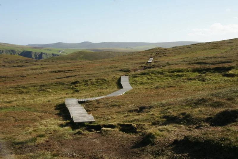
Follow the official boardwalk across moorland to a dramatic, exposed seabird headland.

Decide if the visit fits.
Hermaness National Nature Reserve at a glance
Last checked 18 October 2026.
- Open
- Outdoor trails; no fixed daily opening hours published. Toilets open in the main visitor season.More about open
- Price / parking
- Price not published by operatorMore about price / parking
- Best time
- Seabird colonies in late spring and summerMore about best time
- Dogs
- Keep dogs under close control on the official route and follow t…More about dogs
- Toilets
- NatureScot lists toilets at the car park during the main visitor…More about toilets
- Step-free
- A boardwalk improves the route across wet moorland but does not…More about step-free
Opening and charges information · checked .
Stay nearby →On this page
Reserve overview
Hermaness reserve and habitat
Follow the official boardwalk across moorland to a dramatic, exposed seabird headland.
Eight checks for a smoother visit.
Planning your visit to Hermaness
Conditions change: check the operator and transport notices before travelling.
Hermaness best time to visit and seasonal birds
January: Fulmar is typically the useful focus from Toolie clifftop path. The main seabird spectacle is absent or much reduced; only walk if wind, visibility and daylight permit a safe return. February: Fulmar is typically the useful focus from Toolie clifftop path. The main seabird spectacle is absent or much reduced; only walk if wind, visibility and daylight permit a safe return. March: Skylark is typically the useful focus from Saito Trail moorland boardwalk. Keep to the signed trail and watch without approaching birds. The calendar indicates typical timing, not a sighting promise. April: Puffin is typically the useful focus from Toolie clifftop path. Keep to the signed trail and watch without approaching birds. The calendar indicates typical timing, not a sighting promise. May: Gannet is typically the useful focus from Neap public clifftop view. Keep to the signed trail and watch without approaching birds. The calendar indicates typical timing, not a sighting promise. June: Puffin is typically the useful focus from Toolie clifftop path. Keep to the signed trail and watch without approaching birds. The calendar indicates typical timing, not a sighting promise. July: Kittiwake is typically the useful focus from Neap public clifftop view. Keep to the signed trail and watch without approaching birds. The calendar indicates typical timing, not a sighting promise. August: Gannet is typically the useful focus from Saito public clifftop path. Keep to the signed trail and watch without approaching birds. The calendar indicates typical timing, not a sighting promise. September: Gannet is typically the useful focus from Neap public clifftop view. Keep to the signed trail and watch without approaching birds. The calendar indicates typical timing, not a sighting promise. October: Fulmar is typically the useful focus from Toolie clifftop path. The main seabird spectacle is absent or much reduced; only walk if wind, visibility and daylight permit a safe return. November: Wren is typically the useful focus from Saito Trail moorland boardwalk. The main seabird spectacle is absent or much reduced; only walk if wind, visibility and daylight permit a safe return. December: Fulmar is typically the useful focus from Toolie clifftop path. The main seabird spectacle is absent or much reduced; only walk if wind, visibility and daylight permit a safe return.
Best conditions: Usually choose a settled day with good visibility. Strong wind and low cloud can make exposed cliff routes unsafe; shorten the walk before visibility or daylight deteriorates. Use binoculars first, with a scope useful for offshore stacks on a calm day. Light ratings are editorial, not compass measurements.
Hermaness opening times, entry and facilities
Visitor arrangements, checked 18 October 2026: Hermaness is a NatureScot reserve reached on foot from the official car park, without a general admission ticket. NatureScot provides a welcome area and seasonal toilets; use its visitor page for the current position before travelling. Ferries needed to reach Unst are separate journeys and may require a vehicle reservation. The reserve's specific self-contained motorhome scheme has its own conditions and limited capacity, so it should not be treated as general permission for an overnight stay. Check the reserve notices, the local forecast and your ferry service information before setting off, because wind and sea conditions can change both the walk and the journey.
Access times: Reserve: Outdoor paths have no published daily gate timetable; follow current NatureScot notices and weather conditions. · Hides: No public enclosed bird hide is advertised. The named views are outdoor paths. · Car park: Official car park provided; no daily locking timetable stated. Seasonal toilets are not evidence of year-round facility opening. · Dawn access: partly. Operator opening information.
Hermaness trails, hides and visit length
The official approach crosses moorland before reaching the coast. Keep to the signed path and boardwalk, which protects soft ground as well as making the route clearer. Walk slowly enough to notice the change from small moorland birds to the larger movements over the cliffs, and stop at an established viewing area before lifting binoculars. The cliffs are unfenced in places and are no place to walk while looking through optics. Give other visitors space to pass on the path, particularly where someone has paused with a telescope. Two-hour plan, editorial suggestion: use a short out-and-back on the official route, with the turnaround determined by conditions and your comfortable walking speed. Do not expect to complete every cliff viewpoint in this time; a patient moorland session and one safe coastal view can be a better introduction than a hurried circuit. Make the return before fatigue or worsening weather reduces your margin. Full-day plan, editorial suggestion: begin after a relaxed breakfast on Unst, walk the signed headland route with ample pauses, and take a sheltered lunch away from wildlife and the cliff edge. Spend the afternoon studying one colony viewpoint and the sea beyond, then return with enough time for a slower party member. Keep the final transport arrangement deliberately spacious. If the wind makes cliff watching unsafe, remain around the welcome area or choose a less exposed Unst outing; there is no need to force a complete circuit to justify the journey. A colony is easiest to understand if you divide the view into manageable parts. Watch the air above a cliff first, then a section of ledge and finally the water below, allowing time for behaviour to repeat. Notice how birds land, carry material or exchange places, without attempting a precise colony count from a casual watch. For photography, find a secure viewpoint and let flying birds come through the frame. Moving closer to an edge or stepping off the route to improve the angle adds risk without improving your understanding of the birds.
Where to watch at Hermaness
Use the linked reserve map and directions with current access notices. Species are typical seasonal targets. Light and telescope advice reflects our choice of viewpoint.
Saito Trail moorland boardwalkWinter · Spring · Summer · Autumn
Blanket bog beside the boardwalk
Stay on boardwalk; do not enter moorland or approach pools.
Winter: Wren
Spring: Golden Plover, Dunlin, Skylark
Summer: Golden Plover, Dunlin, Snipe
Autumn: Twite, Meadow Pipit
Light: either. Scope: not needed.
Toolie clifftop pathWinter · Spring · Summer · Autumn
Western cliffs and open sea
Unfenced cliffs; no approach to burrows.
Winter: Fulmar
Spring: Puffin, Fulmar, Guillemot
Summer: Puffin, Guillemot, Kittiwake
Autumn: Gannet, Fulmar
Light: either. Scope: useful.
Neap public clifftop viewWinter · Spring · Summer · Autumn
Neap gannet cliffs and offshore water
View from the official Saito Trail, behind cliff edges.
Winter: Fulmar
Spring: Gannet, Kittiwake
Summer: Gannet, Guillemot, Razorbill
Autumn: Gannet, Fulmar
Light: either. Scope: useful.
Saito public clifftop pathWinter · Spring · Summer · Autumn
Southern western cliffs and sea
Toolie–Saito section narrow and uneven; steps and steep slopes.
Winter: Fulmar
Spring: Gannet, Shag
Summer: Gannet, Shag, Razorbill
Autumn: Gannet, Shag
Light: either. Scope: useful.
Muckle Flugga Trail and old signal-station viewWinter · Spring · Summer · Autumn
Northern cliffs, Muckle Flugga and offshore stacks
Strenuous signed trail; boggy ground, steps and steep sections. No route to offshore stacks.
Winter: Fulmar
Spring: Gannet, Fulmar
Summer: Gannet, Kittiwake, Puffin
Autumn: Gannet, Fulmar
Light: either. Scope: essential.
| Spot | Overlooks | Key species by season | Best light | Scope | Tide |
|---|---|---|---|---|---|
| Saito Trail moorland boardwalkStay on boardwalk; do not enter moorland or approach pools. | Blanket bog beside the boardwalk | Winter: Wren Spring: Golden Plover, Dunlin, Skylark Summer: Golden Plover, Dunlin, Snipe Autumn: Twite, Meadow Pipit | either | not needed | — |
| Toolie clifftop pathUnfenced cliffs; no approach to burrows. | Western cliffs and open sea | Winter: Fulmar Spring: Puffin, Fulmar, Guillemot Summer: Puffin, Guillemot, Kittiwake Autumn: Gannet, Fulmar | either | useful | — |
| Neap public clifftop viewView from the official Saito Trail, behind cliff edges. | Neap gannet cliffs and offshore water | Winter: Fulmar Spring: Gannet, Kittiwake Summer: Gannet, Guillemot, Razorbill Autumn: Gannet, Fulmar | either | useful | — |
| Saito public clifftop pathToolie–Saito section narrow and uneven; steps and steep slopes. | Southern western cliffs and sea | Winter: Fulmar Spring: Gannet, Shag Summer: Gannet, Shag, Razorbill Autumn: Gannet, Shag | either | useful | — |
| Muckle Flugga Trail and old signal-station viewStrenuous signed trail; boggy ground, steps and steep sections. No route to offshore stacks. | Northern cliffs, Muckle Flugga and offshore stacks | Winter: Fulmar Spring: Gannet, Fulmar Summer: Gannet, Kittiwake, Puffin Autumn: Gannet, Fulmar | either | essential | — |
Target species at Hermaness
Month chips show typical presence or our preferred viewing season. Choose birds that suit the time of your visit.
Headline birds
- AprMayJunJulAugSep
- AprMayJunJulAug
- Great SkuaFollow the operator’s sensitive-species advice.AprMayJunJulAugSep
Regular birds
- AprMayJunJul
- AprMayJunJul
- AprMayJunJulAug
- JanFebMarAprMayJunJulAugSepOctNovDec
- JanFebMarAprMayJunJulAugSepOctNovDec
- AprMayJunJulAug
- AprMayJunJulAug
- AprMayJunJulAug
- MarAprMayJunJulAug
- AprMayJunJulAugSep
- AprMayJunJulAugSep
- JanFebMarAprMayJunJulAugSepOctNovDec
Scarce but regular birds
- Red-throated DiverFollow the operator’s sensitive-species advice.AprMayJunJulAug
Tide planning
Clifftop watching is governed primarily by wind and visibility, not a tidal crossing. Use Burra Firth predictions for coastal context; never descend sea cliffs or treat a low tide as permission to reach offshore stacks.
Hermaness accessibility and step-free routes
A boardwalk improves the route across wet moorland but does not make the entire headland a level, sheltered or step-free outing. The path has gradients, exposed sections and natural surfaces at viewing areas. Discuss the actual route and your equipment with NatureScot if you use a wheelchair, scooter or walking aid, rather than relying on a photograph of one smooth stretch. The welcome area can provide a shorter shared destination for a group whose members have different walking ranges. Toilets at the car park are seasonal; plan personal-care needs before the final drive north. Wind can make balance and opening a vehicle door more difficult, and a person who walks comfortably in town may find the same distance tiring on this headland. Carry a warm layer that can be put on without unpacking everything. Choose a viewing position well back from the drop and use binoculars there; a closer cliff-edge position rarely compensates for an insecure stance. Return by the official route while everyone still has a comfortable reserve of energy.
Hermaness visitor facilities
Bring food, a full drink bottle and warm waterproof clothing. NatureScot lists toilets at the car park during the main visitor season; there is no café on the headland. Obtain supplies in the settlements before the final approach rather than expecting a shop at the trailhead. A small rucksack leaves hands free on the boardwalk, while a cover protects optics from squalls. Carry a paper map or downloaded route and a charged phone, but organise the day so it does not depend on a continuous signal.
Hermaness dog rules
Keep dogs under close control on the official route and follow the current NatureScot advice around breeding birds. A short lead prevents a sudden run into moorland or towards a cliff edge. Do not let a dog approach a defensive bird, and avoid lingering where its presence is causing alarm. Take waste away from the reserve.
Hermaness public transport and getting there
Reaching Unst from Shetland Mainland requires the Toft–Ulsta crossing to Yell and the Gutcher–Belmont crossing onwards to Unst. Use Shetland Islands Council's ferry timetable and booking information for the actual day; plan both crossings and their return legs together. The road across Yell is another part of the journey, not waiting time already included in a ferry reservation. From Unst's settlements, follow the official road signs towards Burrafirth and Hermaness. NatureScot says the Lerwick–Baltasound bus cannot support a same-day public-transport return to Lerwick, so a car-free plan needs an Unst overnight and a separately arranged final connection. ZetTrans is the source for the current bus pattern. The stay-base drive estimates below are wholly on Unst and exclude any earlier inter-island crossings, check-in, parking or walking.
Useful bases for an early start.
Where to stay near Hermaness
Booking.com links are affiliate links: we may earn a commission at no extra cost to you. How these links work.
- 01
Baltasound
About 6 miles by road, roughly 12 minutes’ drive to Hermaness car park; OSRM/OpenStreetMap estimate measured 18 October 2026. The drive from Baltasound leaves parking and the final walk to Hermaness National Nature Reserve to be added separately.
Measured driving route · 2026-10-18. Map estimates exclude live traffic.
A practical Unst base with time to choose the best weather day.Find places to stay in Baltasound on Booking.com - 02
Haroldswick
About 3.6 miles by road, roughly 10 minutes’ drive to Hermaness car park; OSRM/OpenStreetMap estimate measured 18 October 2026. The drive from Haroldswick leaves parking and the final walk to Hermaness National Nature Reserve to be added separately.
Measured driving route · 2026-10-18. Map estimates exclude live traffic.
Staying on northern Unst, close to the final approach.Find places to stay in Haroldswick on Booking.com - 03
Uyeasound
About 12.1 miles by road, roughly 23 minutes’ drive to Hermaness car park; OSRM/OpenStreetMap estimate measured 18 October 2026. The drive from Uyeasound leaves parking and the final walk to Hermaness National Nature Reserve to be added separately.
Measured driving route · 2026-10-18. Map estimates exclude live traffic.
An Unst stay near the southern arrival side of the island.Find places to stay in Uyeasound on Booking.com
Explore Shetland’s full guides and smaller birding sites
Hermaness official sightings, safety and contact
Use the NatureScot Hermaness page for reserve questions and Shetland Islands Council for ferry bookings or disruption. Give the name of both ferry routes when discussing a connection, and explain any mobility requirement before travel. For a car-free stay, confirm collection details with the accommodation provider or taxi operator before arriving on Unst. Report path damage or a wildlife concern through the reserve's official contact route; avoid posting detailed breeding locations alongside photographs.
Hermaness recent bird sightings
Check Shetland Bird Club / Nature in Shetland regional observations. dated archive; latest displayed section June 2025 when reviewed, not a verified October 2026 feed Reports show what has been seen, not what will be.
- Shetland Bird Club / Nature in Shetland regional observationscounty club or recorder · updated dated archive; latest displayed section June 2025 when reviewed, not a verified October 2026 feed
Birding sources
Follow the BTO Birders’ Code and give wildlife space.
Questions visitors ask
Is Hermaness National Nature Reserve free to visit?
Hermaness National Nature Reserve: Price not published by operator.
Can I take my dog to Hermaness National Nature Reserve?
Hermaness National Nature Reserve: Keep dogs under close control on the official route and follow the current NatureScot advice around breeding birds.
When is the best time to visit Hermaness National Nature Reserve?
Hermaness National Nature Reserve: Seabird colonies in late spring and summer.
Is Hermaness National Nature Reserve accessible for wheelchairs?
Hermaness National Nature Reserve: A boardwalk improves the route across wet moorland but does not make the entire headland a level, sheltered or step-free outing.
How do I get to Hermaness National Nature Reserve without a car?
Hermaness National Nature Reserve: Reaching Unst from Shetland Mainland requires the Toft–Ulsta crossing to Yell and the Gutcher–Belmont crossing onwards to Unst.
Best months for this reserve
Nearby complete guides.
Bird reserves near Hermaness
Stops with a purpose: use one as a contrasting habitat or weather-proof Plan B. Distances are straight-line estimates, not road journeys.
- About 16 miles away · A useful habitat changeRSPB FetlarLate spring and summer · official-hide phalarope watching
- About 57 miles away · A useful habitat changeRSPB MousaSpring and autumn passage; seasonal breeding and winter birds
- About 62 miles away · A useful habitat changeRSPB Loch of SpiggieSpring and autumn passage; seasonal breeding and winter birds