
Short entry13.4 miles away
St Cyrus National Nature Reserve
Near Northwater Bridge, north of Montrose · Coastal grassland, dunes, beach, cliffs and estuary
 the ai birderBirding near me
The AI Birder · one-page field sheet
Crawton, near Stonehaven, Aberdeenshire, Scotland · AB39 2TP · AB39 2TP

Current planning alert (2026-10-09): Fowlsheugh’s cliff path is exposed and uneven, with steps near the entrance. There are no toilets or onsite staff; plan facilities before travelling and keep the access road clear.
Shag · Herring Gull · Great Black-backed Gull · Gannet · Yellowhammer
Crawton entrance clifftop trail · Public clifftop path along the colony · Stone shelter at the trail end
Check current access, hide closures and operator notices before travelling. Seasonal birds are possibilities, not promised sightings. Keep to authorised routes and give wildlife space.
Opening and charges checked 2026-10-25. Operator: https://www.rspb.org.uk/days-out/reserves/fowlsheugh
Full guide and current source links: https://aibirder.co.uk/reserves/rspb-fowlsheugh
SC 12 · RSPB reserve guide
Crawton, near Stonehaven, Aberdeenshire, Scotland · AB39 2TP
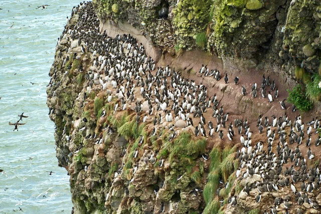
More than 115,000 breeding seabirds occupy the cliffs in spring and summer. Guillemots, Razorbills and Kittiwakes dominate the ledges, with smaller numbers of Puffins and Fulmars, while Grey Seals and dolphins are possible offshore.
Decide if the visit fits.
Last checked 18 October 2026.
Fowlsheugh’s cliff path is exposed and uneven, with steps near the entrance. There are no toilets or onsite staff; plan facilities before travelling and keep the access road clear.
Opening and charges information · checked .
Stay nearby →Reserve overview
More than 115,000 breeding seabirds occupy the cliffs in spring and summer. Guillemots, Razorbills and Kittiwakes dominate the ledges, with smaller numbers of Puffins and Fulmars, while Grey Seals and dolphins are possible offshore.
Eight checks for a smoother visit.
Conditions change: check the operator and transport notices before travelling.
January: typically look for Herring Gull from Public clifftop path along the colony. Use the official clifftop route, keeping back from edges. Outside the main May–earlyAugust colony window, expect a quieter coast walk and do not assume that breeding birds remain on their ledges. February: typically look for Yellowhammer from Crawton entrance clifftop trail. Use the official clifftop route, keeping back from edges. Outside the main May–earlyAugust colony window, expect a quieter coast walk and do not assume that breeding birds remain on their ledges. March: typically look for Skylark from Crawton entrance clifftop trail. Use the official clifftop route, keeping back from edges. Outside the main May–earlyAugust colony window, expect a quieter coast walk and do not assume that breeding birds remain on their ledges. April: typically look for Fulmar from Public clifftop path along the colony. Use the official clifftop route, keeping back from edges. Outside the main May–earlyAugust colony window, expect a quieter coast walk and do not assume that breeding birds remain on their ledges. May: typically look for Guillemot from Public clifftop path along the colony. Use the official clifftop route, keeping back from edges. Outside the main May–earlyAugust colony window, expect a quieter coast walk and do not assume that breeding birds remain on their ledges. June: typically look for Razorbill from Public clifftop path along the colony. Use the official clifftop route, keeping back from edges. Outside the main May–earlyAugust colony window, expect a quieter coast walk and do not assume that breeding birds remain on their ledges. July: typically look for Kittiwake from Stone shelter at the trail end. Use the official clifftop route, keeping back from edges. Outside the main May–earlyAugust colony window, expect a quieter coast walk and do not assume that breeding birds remain on their ledges. August: typically look for Gannet from Stone shelter at the trail end. Use the official clifftop route, keeping back from edges. Outside the main May–earlyAugust colony window, expect a quieter coast walk and do not assume that breeding birds remain on their ledges. September: typically look for Gannet from Stone shelter at the trail end. Use the official clifftop route, keeping back from edges. Outside the main May–earlyAugust colony window, expect a quieter coast walk and do not assume that breeding birds remain on their ledges. October: typically look for Great Black-backed Gull from Public clifftop path along the colony. Use the official clifftop route, keeping back from edges. Outside the main May–earlyAugust colony window, expect a quieter coast walk and do not assume that breeding birds remain on their ledges. November: typically look for Shag from Public clifftop path along the colony. Use the official clifftop route, keeping back from edges. Outside the main May–earlyAugust colony window, expect a quieter coast walk and do not assume that breeding birds remain on their ledges. December: typically look for Herring Gull from Public clifftop path along the colony. Use the official clifftop route, keeping back from edges. Outside the main May–earlyAugust colony window, expect a quieter coast walk and do not assume that breeding birds remain on their ledges.
Best conditions: Usually choose clear visibility and modest wind for identifying birds on the ledges. Persistent rain can reduce grassland activity, while strong gusts make the clifftop unsafe. Use a secure public position and stop before weather deteriorates; autumn and winter lack the crowded summer colony and should be planned as a shorter coast walk.
Information checked 18 October 2026: RSPB lists adult and child admission as free. There is no visitor reception to open. Aberdeenshire Council manages the small Crawton car park, with twelve spaces and no room suitable for coaches or caravans. A current parking tariff was not verified; do not assume free parking simply because reserve admission is free. If the spaces are full, RSPB asks visitors to return on another day. Verges and passing places must remain clear for residents and emergency vehicles. Groups of ten or more should contact RSPB before bringing an organised party, rather than treating the capacity of the cliff path as permission for coach access. Check the current RSPB notices and forecast before making a journey that depends on this exposed route.
Access times: Reserve: Current October 2026 RSPB calendar lists nature reserve open24hours; exposed clifftop route must fit safe weather and daylight. · Hides: Small open trail-end shelter, no independent locking hours published. No staffed reception or enclosed hide circuit. · Car park: Small council-managed Crawton car park; no independent gate timetable or current tariff verified. If full, return another day rather than parking verges. · Dawn access: partly. Operator opening information.
One formal nature trail leads along the cliff top, with many informal views of the nesting ledges and a small shelter towards its far end. RSPB places that shelter one mile, or 1.5 kilometres, from the entrance, so allow for the return journey as well as the outward walk. There is no circuit of conventional bird hides and no reason to descend towards the breeding cliffs. Two-hour plan: walk out slowly, stopping at safe positions to learn the main colony birds, then spend a sustained period watching from the shelter area before returning along the same trail. In the nesting season, compare the crowded Guillemot groups with Razorbills on less tightly packed positions and watch the sea below for birds returning with food. Full-day plan: make Fowlsheugh the centrepiece of a longer, unhurried coast visit rather than trying to turn its short trail into an all-day hike. Bring lunch, complete an extended morning colony watch and return to Stonehaven for facilities or a break; a second observation session can show different activity if conditions and parking permit. Outside summer, one shorter watch may be more rewarding than waiting for birds that have left the colony. Keep binocular straps and loose items secure, choose a stable position away from the edge and let other walkers pass without stepping towards the drop. Do not lean over to improve a photograph or move onto burrowed ground after noticing a Puffin. Listen as well as look: a mixed colony's calls, movement and repeated arrivals are part of the experience even when the few Puffins remain elusive.
Use the linked reserve map and directions with current access notices. Species are typical seasonal targets. Light and telescope advice reflects our choice of viewpoint.
Coastal grassland and adjacent fields
Unsurfaced trail with two flights of steps near start and 1m entrance gate.
Winter: Yellowhammer
Spring: Skylark, Yellowhammer
Summer: Skylark, Yellowhammer
Autumn: Yellowhammer
Light: either. Scope: not needed.
Seabird ledges and open sea
Watch from secure positions on public trail; do not descend ledges.
Winter: Herring Gull, Great Black-backed Gull, Shag
Spring: Guillemot, Razorbill, Fulmar
Summer: Guillemot, Razorbill, Kittiwake, Shag
Autumn: Herring Gull, Great Black-backed Gull
Light: either. Scope: useful.
Cliff ledges and offshore passage
Shelter approximately 1 mile/1.5km from entrance; allow for return. Do not step onto burrowed ground.
Winter: Herring Gull, Shag
Spring: Fulmar, Kittiwake
Summer: Puffin, Kittiwake, Guillemot, Gannet
Autumn: Gannet, Great Black-backed Gull
Light: either. Scope: essential.
| Spot | Overlooks | Key species by season | Best light | Scope | Tide |
|---|---|---|---|---|---|
| Crawton entrance clifftop trailUnsurfaced trail with two flights of steps near start and 1m entrance gate. | Coastal grassland and adjacent fields | Winter: Yellowhammer Spring: Skylark, Yellowhammer Summer: Skylark, Yellowhammer Autumn: Yellowhammer | either | not needed | — |
| Public clifftop path along the colonyWatch from secure positions on public trail; do not descend ledges. | Seabird ledges and open sea | Winter: Herring Gull, Great Black-backed Gull, Shag Spring: Guillemot, Razorbill, Fulmar Summer: Guillemot, Razorbill, Kittiwake, Shag Autumn: Herring Gull, Great Black-backed Gull | either | useful | — |
| Stone shelter at the trail endShelter approximately 1 mile/1.5km from entrance; allow for return. Do not step onto burrowed ground. | Cliff ledges and offshore passage | Winter: Herring Gull, Shag Spring: Fulmar, Kittiwake Summer: Puffin, Kittiwake, Guillemot, Gannet Autumn: Gannet, Great Black-backed Gull | either | essential | — |
Month chips show typical presence or our preferred viewing season. Choose birds that suit the time of your visit.
The official route is on clifftops and has no tidal crossing. Use Stonehaven predictions for coastal context only; a low tide is not permission to descend to ledges or foreshore. Wind, swell and safe footing determine whether the watch is sensible.
Season: Seabird colony: operator highlights May to early August; Guillemots, Razorbills and Kittiwakes lead, with Puffins in smaller numbers.. Arrival time: Choose a safe daylight spell and use the official clifftop trail or stone shelter. Allow a settled watch for birds returning from fishing; no fixed daily arrival time is published.. Hotline: https://www.rspb.org.uk/days-out/reserves/fowlsheugh. Ordinary reserve entry is free; groups of ten or more must contact RSPB. Use the small council Crawton car park; if full, return another day. No booking for an unstaffed ordinary trail watch is advertised; guided events have their own operator listing.
The reserve's coastal route is unsurfaced and uneven, with two flights of steps near its beginning and a one-metre gate at the entrance. RSPB does not list it as suitable for wheelchairs or pushchairs. The car park is approximately one hundred metres from the reserve entrance, but that short approach does not describe the difficulty of the full cliff path. Perch-style benches occur at irregular intervals and have neither arms nor backs, which matters if you need support when sitting or standing. There is no accessible toilet on site. An exposed path also creates difficulties beyond measured width: wind, wet grass and uneven footing can make a nominally short outing unsuitable for someone who depends on a walking aid. Contact RSPB beforehand if you need a precise description of the first section or wish to assess whether a limited visit is realistic. Plan the turnaround while you still have the strength and balance needed for the return steps. The shelter is a wildlife viewpoint at the far end of the route, not a substitute for accessible indoor facilities. Choose another reserve if a step-free seabird-viewing route is essential.
There are no toilets, baby-changing facilities, café, shop or visitor centre, and the reserve has no permanent on-site staff. RSPB identifies Stonehaven, around five miles away, as the nearest place for toilets and refreshments. Bring water and any food you need for the visit, using town facilities before setting off. No bicycle racks are provided. Barbecues are not permitted at RSPB Fowlsheugh because of fire risk. Take litter away and avoid placing food on the cliff-side ground, where birds may investigate it. Peak breeding-season guided walks are listed, but require separate arrangements.
Keep dogs on leads throughout the reserve, as RSPB requests to protect breeding birds. Visitors with assistance dogs are welcome at RSPB Fowlsheugh. A dog must remain under close control on the exposed coastal path, with room left for other walkers; do not allow it to approach nesting areas or run towards the cliff edge while you concentrate on binoculars.
Stonehaven is the nearest railway station. A pre-booked taxi to Crawton, with a return collection arranged, provides a practical final link without depending on a rural bus connection. Stagecoach's 107 timetable links Stonehaven and Montrose via Kinneff, Inverbervie and Johnshaven. RSPB describes a request stop at the start of the Crawton road on the Stonehaven–Johnshaven route, leaving just over a mile to walk to the reserve; confirm the exact stop and safe approach with the operator before using that option. The timetable should not be read as a bus into the car park. National Cycle Network Route 1 passes about one mile from the reserve. Drivers leave the A92 south of Stonehaven at the signed Crawton turn and follow the road towards its end. Do not block passing places when meeting traffic, and arrange taxi collection away from a turning manoeuvre or other vehicles.
Useful bases for an early start.
Booking.com links are affiliate links: we may earn a commission at no extra cost to you. How these links work.
About 4.7 miles by road, roughly 9 minutes’ drive from the mapped settlement centre to the reserve entrance point; OSRM/OpenStreetMap estimate measured 18 October 2026, excluding live traffic.
Measured driving route · 2026-10-18. Map estimates exclude live traffic.
The nearest rail-connected town and facilities base.Find places to stay in Stonehaven on Booking.comAbout 7.0 miles by road, roughly 12 minutes’ drive from the mapped settlement centre to the reserve entrance point; OSRM/OpenStreetMap estimate measured 18 October 2026, excluding live traffic.
Measured driving route · 2026-10-18. Map estimates exclude live traffic.
A smaller coastal settlement south of the reserve.Find places to stay in Inverbervie on Booking.comAbout 19.6 miles by road, roughly 31 minutes’ drive from the mapped settlement centre to the reserve entrance point; OSRM/OpenStreetMap estimate measured 18 October 2026, excluding live traffic.
Measured driving route · 2026-10-18. Map estimates exclude live traffic.
A separate coastal town for a longer birding break.Find places to stay in Montrose on Booking.comExplore Aberdeenshire’s full guides and smaller birding sites
The operator lists strathbeg@rspb.org.uk and 01346 532017 as the Fowlsheugh contact, reflecting management through the wider RSPB team rather than an on-site reception. Check the operator's information, weather and onward transport before travelling. Ask about a guided walk in advance if that forms the purpose of your trip. A historical sighting or photograph does not establish present colony occupancy, especially after the breeding season, so use the seasonal guidance to decide whether this is the right coastal visit for your aims.
Check RSPB Aberdeen group actual Fowlsheugh observations,June 2026. individual dated outing report, updated 11 June 2026 Reports show what has been seen, not what will be.
Follow the BTO Birders’ Code and give wildlife space.
RSPB Fowlsheugh: Free entry; council car park.
RSPB Fowlsheugh: Keep dogs on leads throughout the reserve, as RSPB requests to protect breeding birds.
RSPB Fowlsheugh: May to early August seabird colony · year-round cliff walk · autumn and winter sea-watching.
RSPB Fowlsheugh: RSPB does not list it as suitable for wheelchairs or pushchairs.
RSPB Fowlsheugh: Stonehaven is the nearest railway station.
Shorter stops within 15 miles in a straight line. Use the operator’s arrival directions for the journey.
Near Northwater Bridge, north of Montrose · Coastal grassland, dunes, beach, cliffs and estuary
Nearby complete guides.
Stops with a purpose: use one as a contrasting habitat or weather-proof Plan B. Distances are straight-line estimates, not road journeys.