
Short entry5.1 miles away
Carrick-a-Rede coastal walk
Ballintoy, north Antrim coast · Sea cliffs, rocky coast and maritime grassland
 the ai birderBirding near me
The AI Birder · one-page field sheet
Rathlin Island, County Antrim, Northern Ireland · BT54 6RT · BT54 6RT

Raven · Snipe · Oystercatcher · Ringed Plover · Eider · Black Guillemot
West Light main viewing platform · West Light upper reception platform · Roonivoolin public trail · Craigmacagan public trail · Knockans viewpoint · Church Bay public harbour front
Check current access, hide closures and operator notices before travelling. Seasonal birds are possibilities, not promised sightings. Keep to authorised routes and give wildlife space.
Opening and charges checked 2026-10-25. Operator: https://www.rspb.org.uk/days-out/reserves/rathlin-island/
Full guide and current source links: https://aibirder.co.uk/reserves/rspb-rathlin-island
NI 01 · RSPB reserve guide
Rathlin Island, County Antrim, Northern Ireland · BT54 6RT
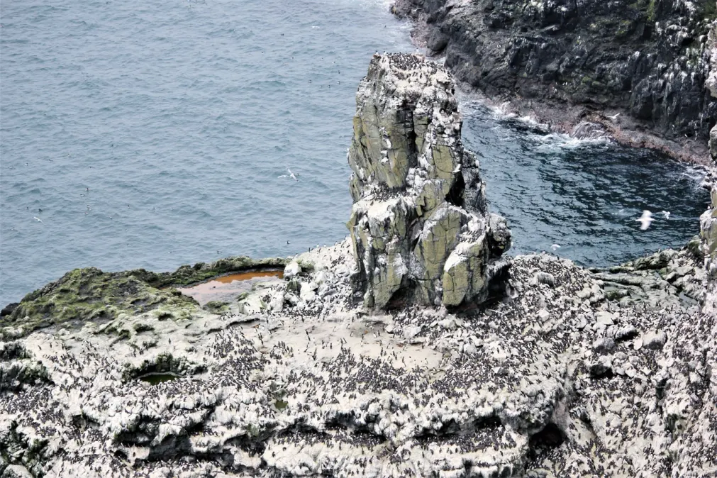
Thousands of Puffins, Guillemots, Kittiwakes, Razorbills and Fulmars gather at Northern Ireland's largest seabird colony; revived hay meadows also give a chance of hearing Corncrakes.
Decide if the visit fits.
Last checked 18 October 2026.
Opening and charges information · checked .
Stay nearby →Reserve overview
Thousands of Puffins, Guillemots, Kittiwakes, Razorbills and Fulmars gather at Northern Ireland's largest seabird colony; revived hay meadows also give a chance of hearing Corncrakes.
Eight checks for a smoother visit.
Conditions change: check the operator and transport notices before travelling.
January: typically watch for Eider from Church Bay public harbour front. The seasonal seabird centre is not a winter attraction. An island visit needs an operating ferry and return contingency; use the public harbour rather than expecting access to locked colony platforms. February: typically watch for Ringed Plover from Roonivoolin public trail. An exposed southern walk needs a favourable forecast and adequate daylight. The official trail offers coastal views without walking onto shorebird feeding ground or taking a shortcut towards the shore. March: typically watch for Skylark from Craigmacagan public trail. Spring grassland listening can complement a harbour visit before centre dates are confirmed. Do not search fields for Corncrake or convert a historical calling record into directions. April: typically watch for Fulmar from West Light main viewing platform. Colony-season access begins only when the RSPB actually opens the centre. Check the year’s dates before booking travel; the typical season is not a 2027 opening announcement. May: typically watch for Guillemot from West Light main viewing platform. Use the official main platform and stay behind barriers. A scope helps compare distant ledges, while access needs include the98steps and a suitable onward bus or walking plan. June: typically watch for Puffin from West Light main viewing platform. The actual June 2026 operator outing documents this colony watch. Watch from managed platforms without approaching burrows, counting an old visit as today’s sightings or following birds away from public facilities. July: typically watch for Razorbill from West Light main viewing platform. Colony movement can make short repeated scans more useful than staring at one place. Leave time for the climb and bus connection rather than relying on the final possible ferry. August: typically watch for Kittiwake from West Light main viewing platform. Early-month seabirds depend on breeding progress and the centre’s actual closing date. Birds can depart before a visitor’s preferred week; no full-colony spectacle is promised throughout August. September: typically watch for Black Guillemot from Church Bay public harbour front. The harbour offers a different island watch after many colony birds leave. Ferries remain weather-dependent, and a public-water target does not mean the West Lightcentre remains open. October: typically watch for Raven from Craigmacagan public trail. The 2026 centre season has ended. Choose a manageable public trail only when weather, ground conditions and transport permit, keeping its outdoor access separate from closed visitor facilities. November: typically watch for Snipe from Craigmacagan public trail. The operator lists Snipe on the island’s grassland trails. Scan quietly from the path, without walking into damp cover to flush a bird for identification or a photograph. December: typically watch for Oystercatcher from Roonivoolin public trail. A winter island day needs conservative travel planning and enough daylight for the return. Watch from the established public route and keep shorebirds feeding undisturbed rather than pursuing a closer view.
Best conditions: Usually choose a clear, moderate-wind day for the colony platforms and allow a ferry cancellation margin. Boat safety and services depend on the operator, not a favourable-looking tide prediction. Main-platform access includes98steps; the upper platform is more accessible but has a restricted distant view. Keep all colony observation on official facilities and sensitive calling birds unlocated.
The published admission tariff checked in October 2026 is £9 adult, £6.50 student and £5 child aged 5–15. Members, people aged 16–24, under-fives and island residents enter free; one child in a family goes free. Roonivoolin and Craigmacagan walking trails are free. Centre entry does not require advance booking, but groups of ten or more should arrange a group visit. Mainland public parking at the harbour/marina, ferry terminal and Sheskburn House has seasonal charges; a current parking tariff was not verified, so budget separately rather than treating parking as free. Admission, parking, ferry and island transfer are separate costs. The official walking map is useful before choosing a route.
Access times: Reserve: RSPB public walking trails remain distinct from seasonal paid West Light facilities; obey local signs and land-management restrictions. · Hides: West Light 2026 visitor season has ended. RSPB says reopen spring 2027, with no exact verified date or daily hours yet. · Car park: Most day visitors park at Ballycastle and travel as foot passengers. Island vehicles need permits except exemptions; West Light turning/drop-off space is very limited. · Dawn access: partly. Operator opening information.
West Light is the destination for the concentrated seabird colony and the unusual lighthouse; the southern walking areas provide a different landscape of grassland, shore and lakes. Download RSPB's trail map before leaving the mainland and select one realistic walking area rather than assuming the island is a single compact reserve. Craigmacagan rewards slow observation of meadow wildlife, while Roonivoolin offers shore watching. Knockans is a useful landscape viewpoint above Church Bay. There are viewing platforms rather than a conventional circuit of enclosed bird hides, so dress for time standing still in the wind. Two-hour plan: treat this as two hours at West Light after reaching the centre, not two hours from the mainland. Settle at the viewing area first, distinguish the tightly packed Guillemots from larger-billed Razorbills and watch the water below for Puffins. Give the lighthouse and interpretation the remaining time, subject to the agreed return transfer; an ordinary shared bus stop may be shorter, so arrange an extended stay before relying on this plan. Full-day plan: take an early booked ferry and transfer to West Light, keeping the colony as the main objective. Return to Church Bay for lunch and, only if there is sufficient margin before boarding, choose a shorter southern walk rather than starting another long crossing of the island. Keep watching from public paths, leave space around nesting birds and do not step onto burrowed cliff-top ground for photographs. An island overnight gives more flexibility for quiet morning observation, but never removes the need to confirm the next crossing.
Use the linked reserve map and directions with current access notices. Species are typical seasonal targets. Light and telescope advice reflects our choice of viewpoint.
Official cliff-colony view and offshore water
98steps down;2026 centre season ended. No exact 2027 opening date confirmed.
Spring: Guillemot, Razorbill, Kittiwake, Fulmar
Summer: Puffin, Guillemot, Razorbill, Kittiwake, Gannet
Light: either. Scope: useful.
Restricted distant cliff-colony view
Wheelchair-accessible upper platform, but private buses are not wheelchair accessible. Seasonal centre access only.
Spring: Guillemot, Fulmar
Summer: Kittiwake, Razorbill
Light: either. Scope: essential.
Signed southern island grassland and coastal views
Rough, hilly and uneven sections; no toilets on trail.
Winter: Oystercatcher, Ringed Plover, Buzzard
Spring: Skylark, Oystercatcher, Buzzard
Summer: Skylark, Ringed Plover, Buzzard
Autumn: Oystercatcher, Ringed Plover, Buzzard
Light: either. Scope: useful.
Signed grassland trail
Public trail has seating; no toilets. Do not leave route to search calling sensitive birds.
Winter: Raven, Snipe
Spring: Skylark, Snipe
Summer: Skylark, Raven
Autumn: Snipe, Raven
Light: either. Scope: useful.
Panorama of Church Bay and wider coast
Official picnic/viewpoint. No close species sightline established; a panorama is not a new colony-access route.
Light: either. Scope: useful.
Public harbour water
Remain on public harbour frontage and clear of working ferry operations.
Winter: Eider, Black Guillemot
Spring: Eider, Black Guillemot
Summer: Eider, Black Guillemot
Autumn: Eider, Black Guillemot
Light: either. Scope: useful.
| Spot | Overlooks | Key species by season | Best light | Scope | Tide |
|---|---|---|---|---|---|
| West Light main viewing platform98steps down;2026 centre season ended. No exact 2027 opening date confirmed. | Official cliff-colony view and offshore water | Spring: Guillemot, Razorbill, Kittiwake, Fulmar Summer: Puffin, Guillemot, Razorbill, Kittiwake, Gannet | either | useful | — |
| West Light upper reception platformWheelchair-accessible upper platform, but private buses are not wheelchair accessible. Seasonal centre access only. | Restricted distant cliff-colony view | Spring: Guillemot, Fulmar Summer: Kittiwake, Razorbill | either | essential | — |
| Roonivoolin public trailRough, hilly and uneven sections; no toilets on trail. | Signed southern island grassland and coastal views | Winter: Oystercatcher, Ringed Plover, Buzzard Spring: Skylark, Oystercatcher, Buzzard Summer: Skylark, Ringed Plover, Buzzard Autumn: Oystercatcher, Ringed Plover, Buzzard | either | useful | — |
| Craigmacagan public trailPublic trail has seating; no toilets. Do not leave route to search calling sensitive birds. | Signed grassland trail | Winter: Raven, Snipe Spring: Skylark, Snipe Summer: Skylark, Raven Autumn: Snipe, Raven | either | useful | — |
| Knockans viewpointOfficial picnic/viewpoint. No close species sightline established; a panorama is not a new colony-access route. | Panorama of Church Bay and wider coast | — | either | useful | — |
| Church Bay public harbour frontRemain on public harbour frontage and clear of working ferry operations. | Public harbour water | Winter: Eider, Black Guillemot Spring: Eider, Black Guillemot Summer: Eider, Black Guillemot Autumn: Eider, Black Guillemot | either | useful | — |
Month chips show typical presence or our preferred viewing season. Choose birds that suit the time of your visit.
Ballycastle Bay is the nearest UKHO catalogue station to Church Bay. Its predictions give mainland departure-area context, not a Rathlin landing guarantee or a permitted shore crossing. Follow Rathlin Ferry sailing and skipper advice.
Operator: Rathlin Ferry Ltd.
Booking opens: Book outward and return sailings online; no annual booking-opening date was verified.. Season: Year-round island connection with seasonal timetables; centre season is separate.. Fares: 2026 tariff: adult £8.40 each way; child 5–15 £4.20; under-fives free with a ticket; bicycle £2.20 each way. Kintra II crossing about 30 minutes, Spirit of Rathlin about 40 minutes.; landing fee: No separate ferry landing charge verified; RSPB admission is listed in Entry..
Time ashore: Choose your return sailing. The Rathlin community transfer page lists summer minibuses taking about 20 minutes each way, ordinarily allowing about one hour at West Light; last outbound bus from Pier 1 listed at 13:30. Published October 2026 bus information: £5 adult/£3 child return, cash only; reconfirm the 2027 operation before booking.. Landing access: Sail from Ballycastle to Church Bay, then take a separately operated seasonal minibus, cycle or walk to West Light.. Weather policy: All sailings are at the skipper’s discretion and subject to weather and other conditions. Retain a mainland contingency if the crossing cannot operate.
Season: Seabird colony usually late April to early August; actual access follows the year’s RSPB centre season. The 2026season has ended and 2027exactdates are unconfirmed.. Arrival time: Book the ferry and allow time for island transfer, the98steps and return connection; no fixed daily seabird arrival is published.. Hotline: https://www.rspb.org.uk/days-out/reserves/rathlin-island. Centre entry ordinarily needs no advance booking, but groups of ten or more should arrange their visit. Ferry and seasonal transfer bookings are separate. Mainland parking charges apply; the upper platform has restricted viewing.
West Light's principal viewing platform is reached by 98 descending steps; the lighthouse's lower floor adds another 64 steps and a steep path. The upper platform is wheelchair accessible, although RSPB describes its view as restricted. This distinction matters when deciding whether the colony views will meet your expectations. Privately operated island buses are not wheelchair accessible according to RSPB, so reaching the upper platform requires a separate transport arrangement. Contact the ferry and reserve teams together before purchasing a journey built around a mobility aid. Spirit of Rathlin lists room for two wheelchairs, which must be reserved; vessel choice therefore forms part of the access plan. Accessible toilets are available at West Light and Church Bay. The off-road walking trails include rough, uneven and hilly sections, with seating at Craigmacagan; they should not be presented as an alternative accessible circuit. Describe your own transfer requirements, whether steps are possible and whether you need to remain in your wheelchair, rather than relying on a general accessibility symbol. Arrange assistance and contingency plans in advance, especially where a missed transfer would affect the return sailing.
The centre provides tea, coffee and snacks, plus picnic seating inside the reception building and immediately outside. Staff can assist with the available binoculars and telescopes. Ordinary toilets and baby-changing facilities are at West Light and Church Bay, with further provision on the car ferry; there are no toilets on the Craigmacagan or Roonivoolin trails. Pack drinking water and a substantial lunch if walking away from the harbour. Barbecues are not permitted at RSPB Rathlin Island. Take litter back to the mainland and check luggage for accidental rodent passengers as part of Rathlin's island biosecurity.
Only assistance dogs can enter the visitor centre, lighthouse and viewing platform. Other dogs arriving by bus must stay with an owner outside and cannot be left unattended. DAERA excludes dogs from Kebble Nature Reserve, through which the walking approach to West Light passes. A pet therefore changes the visit substantially; agree arrangements before committing to a seabird-centre day.
For a car-free mainland approach, Translink lists Ulsterbus 131 between Ballymena and Ballycastle, and 402 between Coleraine and Ballycastle. Use the operator's journey planner for your actual date, including the connection from the relevant railway station; do not assume a bus is timed to a ferry. Marine Corner is the Ballycastle stop shown on the coastal 402 timetable. Build a generous interchange margin and check the last mainland service as carefully as the outward connection. On the island, RSPB gives the harbour-to-West-Light distance as 4.5 miles: this is not a short stroll between landing and colony. Follow signed cycle route 93 if travelling by bicycle, with a cycle space booked on the ferry. Visitors normally leave cars on the mainland; vehicle access requires a permit or a qualifying exemption. Do not plan to hire a car after landing. Transfer bookings and ferry bookings are independent, so record both return arrangements before beginning any walk away from Church Bay.
Useful bases for an early start.
Booking.com links are affiliate links: we may earn a commission at no extra cost to you. How these links work.
About 0.6 miles by road, roughly 2 minutes’ drive from the mapped town centre to Ballycastle ferry terminal; OSRM/OpenStreetMap estimate measured 18 October 2026, excluding parking, boarding, the sea crossing and the island transfer. This is a mainland base, not a drive to the reserve.
Measured driving route · 2026-10-18. Map estimates exclude live traffic.
Staying close to the ferry departure.Find places to stay in Ballycastle on Booking.comAbout 13 miles by road, roughly 18 minutes’ drive from the mapped town centre to Ballycastle ferry terminal; OSRM/OpenStreetMap estimate measured 18 October 2026, excluding parking, boarding, the sea crossing and the island transfer. This is a mainland base, not a drive to the reserve.
Measured driving route · 2026-10-18. Map estimates exclude live traffic.
Combining the island with the western Causeway Coast.Find places to stay in Bushmills on Booking.comAbout 6 miles by road, roughly 9 minutes’ drive from the mapped town centre to Ballycastle ferry terminal; OSRM/OpenStreetMap estimate measured 18 October 2026, excluding parking, boarding, the sea crossing and the island transfer. This is a mainland base, not a drive to the reserve.
Measured driving route · 2026-10-18. Map estimates exclude live traffic.
A smaller mainland village west of Ballycastle.Find places to stay in Ballintoy on Booking.comExplore County Antrim’s full guides and smaller birding sites
RSPB Rathlin Island can be contacted on 028 2076 0062 for reserve-specific arrangements. Use the linked operator pages for centre announcements and the ferry website for sailing status. Check these together before travelling because a mainland transport ticket alone does not confirm island access. The RSPB currently gives spring 2027 as the reopening period; use its latest notice when planning the West Light visit. Send detailed access questions ahead of the trip and report wildlife concerns through the reserve team.
Check RSPB Belfast actualJune 2026 island visit. fixed30 June 2026 account, not a live daily report Reports show what has been seen, not what will be.
Follow the BTO Birders’ Code and give wildlife space.
RSPB Rathlin Island: Adult entry £9 (members/ages 16–24 free); ferry £8.40 adult each way; parking separate.
RSPB Rathlin Island: Only assistance dogs can enter the visitor centre, lighthouse and viewing platform.
RSPB Rathlin Island: Late April–early August.
RSPB Rathlin Island: The upper platform is wheelchair accessible, although RSPB describes its view as restricted.
RSPB Rathlin Island: For a car-free mainland approach, Translink lists Ulsterbus 131 between Ballymena and Ballycastle, and 402 between Coleraine and Ballycastle.
Shorter stops within 15 miles in a straight line. Use the operator’s arrival directions for the journey.
Ballintoy, north Antrim coast · Sea cliffs, rocky coast and maritime grassland
Nearby complete guides.
Stops with a purpose: use one as a contrasting habitat or weather-proof Plan B. Distances are straight-line estimates, not road journeys.