
Short entry1.5 miles away
Westleton Heath National Nature Reserve
Dunwich Road, north-east of Westleton · Lowland heath, grassland and woodland
 the ai birderBirding near me
The AI Birder · one-page field sheet
Suffolk, England · IP17 3DJ · IP17 3DJ

Access notice: Dunwich Heath, beach, car park and paths remain closed following the 29 July 2026 wildfire. Stay away until the National Trust announces safe reopening.
Stonechat · Skylark · Kestrel · Buzzard · Cetti’s Warbler · Kingfisher
Pink walk heathland — closed · Orange/pink woodland routes — closed · Grey walk at Docwra’s Ditch — closed · Clifftop path — closed · Beach — closed
Check current access, hide closures and operator notices before travelling. Seasonal birds are possibilities, not promised sightings. Keep to authorised routes and give wildlife space.
Opening and charges checked 2026-10-18. Operator: https://www.nationaltrust.org.uk/visit/suffolk/dunwich-heath-and-beach
Full guide and current source links: https://aibirder.co.uk/reserves/dunwich-heath-and-beach
EN 57 · National Trust reserve guide
Suffolk, England · IP17 3DJ
Closed after the 2026 wildfire; use the open Minsmere reserve as a separately planned nearby alternative.
Decide if the visit fits.
Last checked 18 October 2026.
Opening and charges information · checked .
Stay nearby →Reserve overview
Closed after the 2026 wildfire; use the open Minsmere reserve as a separately planned nearby alternative.
Eight checks for a smoother visit.
Conditions change: check the operator and transport notices before travelling.
January: Closed-site planning only. Historically, Stonechat and Skylark were heathland targets on Pink walk heathland — closed. That baseline cannot establish what survived the wildfire or which route will reopen. For a visit now, use another reserve’s own entrance and current access information. February: Future planning after an official reopening only: the older operator account associates Green Woodpecker and Bullfinch with Orange/pink woodland routes — closed. Do not walk a remembered trail to test the habitat. Trees and paths require the Trust’s safety assessment before visitors return. March: The reserve remains closed. Historically, Skylark and Stonechat gave reasons to spend time on Pink walk heathland — closed. Spring weather does not remove the restriction. A future itinerary needs newly authorised routes and fresh bird information, rather than a pre-fire seasonal expectation. April: Planning only, with no present access: Whitethroat was a typical spring migrant in the operator’s heathland account for Pink walk heathland — closed. The older colour route is a historical reference. Wait for explicit route permission and evidence of the recovering habitat before choosing a visit. May: No reopening is assumed. A future post-reopening plan might compare Whitethroat on Pink walk heathland — closed with the historically listed Cetti’s Warbler at Grey walk at Docwra’s Ditch — closed. Sensitive species receive no search spot, and this planning comparison is not permission to enter. June: Closed-site planning only: Hobby and Whitethroat appeared in the operator’s pre-fire heathland list for Pink walk heathland — closed. Any future summer watch depends on safe reopening and contemporary observations. Do not approach emergency tracks, breeding cover or a damaged edge for a closer view. July: The Trust’s closure remains the deciding fact. Historically, Hobby could be watched above Pink walk heathland — closed, while Cormorant added coastal interest from Clifftop path — closed. Those former viewing choices must be reassessed, particularly because cliff instability also makes the adjoining beach unsafe. August: Planning for an unspecified future reopening only: Stonechat and Kestrel were characteristic possibilities along Pink walk heathland — closed. No claim is made about their present distribution. Habitat recovery needs space, and a gap in a barrier is not an invitation to investigate it. September: There is no authorised heath visit in this plan. The historical species account suggests Kingfisher at Grey walk at Docwra’s Ditch — closed and Bullfinch on Orange/pink woodland routes — closed. Future watching must use whatever safe routes the Trust eventually publishes, with new seasonal evidence. October: Closed-site planning only: Green Woodpecker and Bullfinch belonged to the older woodland account for Orange/pink woodland routes — closed. Bird news from Dunwich village or other coastal areas must not be transferred into evidence that the National Trust heath is accessible or supports the same birds now. November: Wait for an explicit operator reopening before making a heath itinerary. Historically, Stonechat rewarded Pink walk heathland — closed and Cormorant could be watched from Clifftop path — closed. Neither tide predictions nor an accommodation reservation replaces the safety and access decisions of the site team. December: Planning only, without a reopening date: the old account lists Oystercatcher for Beach — closed and Kingfisher for Grey walk at Docwra’s Ditch — closed. These are historical habitat associations, not current sightings. Choose an open reserve for today and leave recovery work undisturbed.
Best conditions: The site is closed: no weather, tide or season makes a visit permissible. After an explicit reopening, use the Trust’s new route and safety advice before considering the typical calm-morning advantage for listening to heathland birds. Historical light and scope ratings describe an eventual planning approach, not a safe present viewing place.
Closure and opening information checked 18 October 2026: the National Trust calendar marks the heath, car park, visitor information, tea-room and kiosk closed. The closure also includes the beach, King Charles III Coast Path and public rights of way across the site. The Trust says it will reopen when safe and does not publish a reopening date. No future admission or parking tariff is confirmed on the current visitor page, so older prices should not be used to budget a booking. The Trust’s current account dates the wildfire to 29 July 2026. Its warning describes unstable ground, damaged trees, exposed wartime ordnance and risks beneath the surface, as well as cliff instability affecting the beach. These are reasons to stay outside the closure, including if an old map shows a public path. Recheck the National Trust’s dedicated closure notice before making any travel commitment; a booked stay nearby does not provide permission to enter the heath.
Access times: Reserve: CLOSED. Heath, adjoining beach, King Charles III Coast Path and public rights of way across the site remain closed after the 29 July 2026 wildfire. No reopening date is published. · Hides: No watching route or facility is available under the current closure. Historical route labels do not authorise entry. · Car park: CLOSED, along with visitor information, tea-room andkiosk. Do not plan an early, late or pedestrian workaround. · Dawn access: no. Operator opening information.
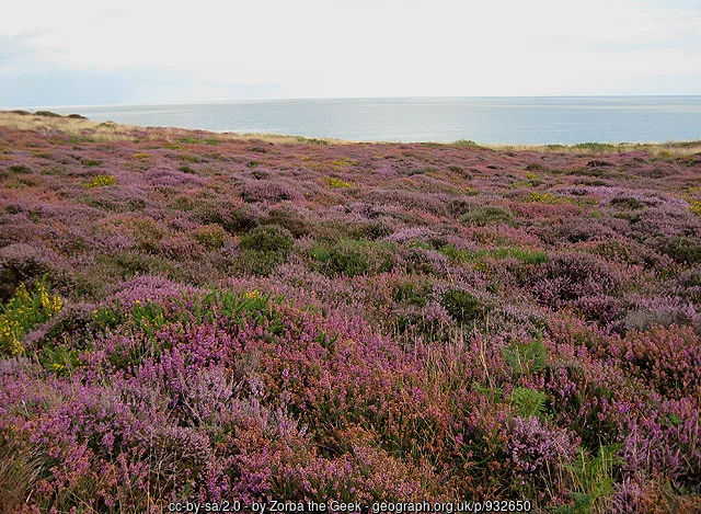
For a visit now, use neighbouring RSPB Minsmere as a separate destination rather than attempting to reach it across the closed heath. The National Trust’s closure article specifically says that Minsmere and Dunwich village remain open. Minsmere is the nearest major birdwatching neighbour, with its own entrance, paths, prices and access arrangements described in our Minsmere guide. Plan the journey to that entrance independently. A future Dunwich walk should be built around the routes actually released by the Trust after its safety assessment. Historic paths and familiar landmarks may have changed, so an old heathland loop is not a reliable instruction for returning visitors. In normal birdwatching terms, the interest comes from the contrast between open heath, scrub, woodland edges and the coast. The value of each area will depend on the recovery of vegetation and where visitors can watch without disturbance. Two-hour plan — future suggestion after reopening only: start with the Trust’s visitor information and choose the shortest permitted heath route that suits the party. Spend more time listening and scanning than walking, then return by the authorised approach. If the reopening notice provides only limited access, keep the visit within that area rather than extending towards a remembered viewpoint. A short watch can still show how birds use a recovering landscape. Full-day plan — future suggestion after reopening only: give the morning to the permitted Dunwich route, take a break, then travel separately to Minsmere for an afternoon wetland watch. This creates a useful contrast of habitats without depending on a coastal through-walk. If no safe heath route has reopened, put the whole birding day into Minsmere instead. Check each operator’s access arrangements for the date before deciding on the sequence. These plans are deliberately conditional because the Trust has not announced the paths that will reopen or when. Do not enter to photograph fire damage or follow a track created by emergency vehicles. Habitat recovery is best watched from approved positions, leaving fragile vegetation and the birds using it undisturbed. The photograph shows the heath before the July 2026 wildfire.
Use the linked reserve map and directions with current access notices. Species are typical seasonal targets. Light and telescope advice reflects our choice of viewpoint.
Historical heath and gorse habitat; current condition and birds cannot be assumed
CLOSED after the July 2026 wildfire. Historical route reference only; no access until the National Trust explicitly reopens that route.
Winter: Stonechat, Skylark
Spring: Stonechat, Skylark, Whitethroat
Summer: Whitethroat, Hobby
Autumn: Stonechat, Kestrel
Light: either. Scope: not needed.
Historical woodland and scrub-edge routes; current vegetation and access need reassessment
CLOSED after the July 2026 wildfire. Historical route reference only; no access until the National Trust explicitly reopens that route.
Winter: Green Woodpecker, Bullfinch
Spring: Green Woodpecker, Bullfinch
Summer: Red Kite
Autumn: Bullfinch
Light: either. Scope: not needed.
Historical wetland-edge walk by Docwra’s Ditch; no present access
CLOSED after the July 2026 wildfire. Historical route reference only; no access until the National Trust explicitly reopens that route.
Winter: Cetti’s Warbler, Kingfisher
Spring: Cetti’s Warbler, Great Spotted Woodpecker
Summer: Buzzard
Autumn: Great White Egret, Kingfisher
Light: either. Scope: useful.
Historical coastal seawatching outlook; cliffs remain unsafe and closed
CLOSED after the July 2026 wildfire. Historical route reference only; no access until the National Trust explicitly reopens that route.
Winter: Cormorant
Spring: Cormorant
Summer: Cormorant
Autumn: Cormorant
Light: either. Scope: useful.
Tide: No present access. An eventual safe route depends on the operator’s assessment, not the tide alone.
Historical shingle beach habitat; beach remains closed
CLOSED after the July 2026 wildfire. Historical route reference only; no access until the National Trust explicitly reopens that route.
Winter: Oystercatcher
Spring: Oystercatcher
Summer: Oystercatcher
Autumn: Oystercatcher
Light: either. Scope: useful.
Tide: No present access. Cliff instability affects the beach regardless of exposed shingle or low water.
| Spot | Overlooks | Key species by season | Best light | Scope | Tide |
|---|---|---|---|---|---|
| Pink walk heathland — closedCLOSED after the July 2026 wildfire. Historical route reference only; no access until the National Trust explicitly reopens that route. | Historical heath and gorse habitat; current condition and birds cannot be assumed | Winter: Stonechat, Skylark Spring: Stonechat, Skylark, Whitethroat Summer: Whitethroat, Hobby Autumn: Stonechat, Kestrel | either | not needed | — |
| Orange/pink woodland routes — closedCLOSED after the July 2026 wildfire. Historical route reference only; no access until the National Trust explicitly reopens that route. | Historical woodland and scrub-edge routes; current vegetation and access need reassessment | Winter: Green Woodpecker, Bullfinch Spring: Green Woodpecker, Bullfinch Summer: Red Kite Autumn: Bullfinch | either | not needed | — |
| Grey walk at Docwra’s Ditch — closedCLOSED after the July 2026 wildfire. Historical route reference only; no access until the National Trust explicitly reopens that route. | Historical wetland-edge walk by Docwra’s Ditch; no present access | Winter: Cetti’s Warbler, Kingfisher Spring: Cetti’s Warbler, Great Spotted Woodpecker Summer: Buzzard Autumn: Great White Egret, Kingfisher | either | useful | — |
| Clifftop path — closedCLOSED after the July 2026 wildfire. Historical route reference only; no access until the National Trust explicitly reopens that route. | Historical coastal seawatching outlook; cliffs remain unsafe and closed | Winter: Cormorant Spring: Cormorant Summer: Cormorant Autumn: Cormorant | either | useful | No present access. An eventual safe route depends on the operator’s assessment, not the tide alone. |
| Beach — closedCLOSED after the July 2026 wildfire. Historical route reference only; no access until the National Trust explicitly reopens that route. | Historical shingle beach habitat; beach remains closed | Winter: Oystercatcher Spring: Oystercatcher Summer: Oystercatcher Autumn: Oystercatcher | either | useful | No present access. Cliff instability affects the beach regardless of exposed shingle or low water. |
Month chips show typical presence or our preferred viewing season. Choose birds that suit the time of your visit.
No coastal access while the closure remains in force. Any future beach or clifftop plan must follow the operator’s reopening assessment; low water does not remove unstable-cliff hazards. No minimum height or preferred watching offset is sourced.
The National Trust links an AccessAble guide for Dunwich Heath, but its older measurements cannot establish the condition of routes after the wildfire. For a future visit, request the new access information when reopening is announced and discuss the exact path, mobility aid and assistance you need. The important questions include surface firmness, gradients, remaining hazards and whether a comfortable return route exists without using an unassessed extension. Do not assume that a previously manageable coast path, beach approach or central circuit will retain the same surface or alignment. Even a short diversion can alter the effort needed by a wheelchair user or someone with limited walking range. A useful plan should identify a definite turnaround point, places to pause and the availability of support at the time of the visit. For birdwatching, also consider whether a safe viewing position gives enough turning space and a comfortable height for binoculars or a telescope. Those details should be confirmed against the reopened layout rather than inferred from an old photograph of a path. If the available route does not suit your party, the separately managed Minsmere guide provides another destination to assess on its own access information. Neither site’s arrangements should be assumed to apply to the other.
Coastguard Cottages is the National Trust’s published visitor address, and its facility list names visitor information, a tea-room and a kiosk. Their future service arrangements will need to be confirmed when access returns. Pack the food, water and equipment needed for whichever open destination you choose for the day, particularly if combining several Suffolk sites. Keep a charged phone and a saved map, and use official notices rather than social-media photographs to decide where visitor facilities are available.
The current site closure applies to visitors bringing dogs as well as other walkers. For a future visit, use the dog-access rules issued with the reopening information and keep to the permitted routes. A recovering heath needs particular care around nesting birds and fragile vegetation. Do not use a dog walk as a reason to enter through a closed path or beach approach.
There is no journey to the heath to recommend while access is prohibited. For a future car-free visit, plan a rail journey to the Suffolk coast and a booked onward taxi only after the Trust confirms the destination is open. Darsham is a practical railway gateway on the East Suffolk Line; check Greater Anglia’s current service information and arrange the road transfer with a local firm in advance rather than expecting a waiting taxi. The Trust’s published road approach is signposted from the A 12 via the Westleton–Dunwich road and Minsmere Road. Keep that as location information, not permission to drive into the closed car park. Likewise, the Sandlings Walk and coastal path appear in historic directions but cannot provide an alternative entrance around a closure barrier. Westleton, Southwold and Saxmundham are distinct nearby stay bases. Their measured road estimates below locate the destination for future planning and do not imply that the route or parking is available to visitors now. A Suffolk stay can instead support an independently planned Minsmere visit, using that reserve’s own transport details.
Useful bases for an early start.
Booking.com links are affiliate links: we may earn a commission at no extra cost to you. How these links work.
About 3.4 miles by road, roughly 10 minutes’ drive; OSRM estimate measured 18 October 2026, without live traffic.
Measured driving route · 2026-10-18. Map estimates exclude live traffic.
A nearby village base for a future heath visit or a separate Minsmere outing. Respect the current closure.Find places to stay in Westleton on Booking.comAbout 10.6 miles by road, roughly 23 minutes’ drive; OSRM estimate measured 18 October 2026, without live traffic.
Measured driving route · 2026-10-18. Map estimates exclude live traffic.
A distinct coastal town for a Suffolk stay with other open destinations.Find places to stay in Southwold on Booking.comAbout 11.7 miles by road, roughly 23 minutes’ drive; OSRM estimate measured 18 October 2026, without live traffic.
Measured driving route · 2026-10-18. Map estimates exclude live traffic.
A rail-linked town base for independently planned Suffolk birding.Find places to stay in Saxmundham on Booking.comExplore Suffolk’s full guides and smaller birding sites
Contact the National Trust at dunwichheath@nationaltrust.org.uk or 01728 648501. The published address is Coastguard Cottages, Minsmere Road, Dunwich, Suffolk, IP 17 3 DJ. Use the dedicated wildfire notice for the latest access decision, and contact the property about a specific future requirement once reopening information appears. The Trust has not given a return date to substitute for that advice. For an immediate birdwatching outing, read the separate RSPB Minsmere guide and contact Minsmere about its own facilities or visit arrangements.
Check National Trust — undated historical habitat sightings list. historical baseline; not a post-fire sightings feed Reports show what has been seen, not what will be.
Follow the BTO Birders’ Code and give wildlife space.
Dunwich Heath and Beach: Price not published by operator; site closed and no reopening tariff confirmed.
Dunwich Heath and Beach: The current site closure applies to visitors bringing dogs as well as other walkers.
Dunwich Heath and Beach: Currently closed · future heathland watching subject to reopening.
Dunwich Heath and Beach: Even a short diversion can alter the effort needed by a wheelchair user or someone with limited walking range.
Dunwich Heath and Beach: There is no journey to the heath to recommend while access is prohibited.
Shorter stops within 15 miles in a straight line. Use the operator’s arrival directions for the journey.
Dunwich Road, north-east of Westleton · Lowland heath, grassland and woodland
Dunwich · Coastal wetland and reedbed
A1095 Halesworth Road, near Southwold · Reedbeds, pools, coastal grazing marsh and river wall
Marsh Lane approach, near Aldeburgh · Tidal marsh, mudflats and estuary pools
Near Wangford, north of Southwold · Ancient coppice woodland and sunny rides
Bridge Road, Snape · Reedbed, grazing marsh, dykes and woodland edge
Church Lane, Iken, near Snape · Saltmarsh and tidal mudflats
Off the B1069 between Tunstall and Snape · Lowland heath, scrub and woodland edge
Boyton · Coastal wetland
Marsh Lane, Worlingham · Grazing marsh, wet woodland, fen, scrub and river
Nearby complete guides.
Stops with a purpose: use one as a contrasting habitat or weather-proof Plan B. Distances are straight-line estimates, not road journeys.