

Short entry3.0 miles away
Brampton Wood
Brampton Road, west of Brampton · Ancient mixed woodland and coppiced rides
 the ai birderBirding near me
The AI Birder · one-page field sheet
West Perry, Cambridgeshire · PE28 0BX

Current planning alert (2026-10-18): Anglian Water warns of soft mud beside low water. Do not enter exposed reservoir bed, inlets or water edges; watch from established public paths and hides.
Great Crested Grebe · Tufted Duck · Coot · Pochard · Wigeon · Dunlin
Mander Hide · Valley Creek Hide · Dudney Hide · Lymage Hide · Littless Hide · Savages Wood Pasture Hide · Savages Hide · Lagoons Hide · Dam public path · Marlow public shore path · Littless Wood paths
Check current access, hide closures and operator notices before travelling. Seasonal birds are possibilities, not promised sightings. Keep to authorised routes and give wildlife space.
Opening and charges checked 2026-10-18. Operator: https://anglianwaterparks.co.uk/grafham-water-park/nature-wildlife
Full guide and current source links: https://aibirder.co.uk/reserves/grafham-water
EN 102 · Anglian Water reserve guide
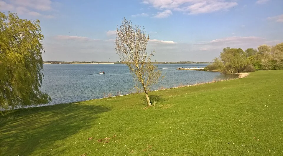
West Perry, Cambridgeshire
A western nature reserve with contrasting lake, creek and woodland views.
Decide if the visit fits.
Last checked 18 October 2026.
Anglian Water warns of soft mud beside low water. Do not enter exposed reservoir bed, inlets or water edges; watch from established public paths and hides.
Opening and charges information · checked .
Stay nearby →Reserve overview
A western nature reserve with contrasting lake, creek and woodland views.
Eight checks for a smoother visit.
Conditions change: check the operator and transport notices before travelling.
January: typically compare Tufted Duck and Pochard at Dudney Hide with Goldeneye in Savages Creek from Savages Hide. The car parks open at 9am, so this is a daylight itinerary.
February: usually combine the quieter creek hides for Wigeon and Goldeneye with Marlow public shore path for Great Crested Grebes. A distant diver requires patient telescope identification.
March: typically Great Crested Grebes and remaining winter ducks justify Dudney Hide before a walk through Littless Wood paths for Nuthatch and Marsh Tit. Use the current access statement for steps.
April: usually watch Common Tern movements from Dudney Hide and compare the Dam public path for passing Common Sandpiper. Stay off mud exposed by fluctuating reservoir levels.
May: typically migration adds interest to the Dam public path: Sanderling and Common Sandpiper are possibilities. Common Terns can also be watched from Dudney Hide without approaching the raft.
June: usually a slower circuit through Littless Wood paths for Nuthatch and Great Spotted Woodpecker complements Great Crested Grebes from Dudney Hide. Avoid any temptation to follow calls off the trail.
July: typically start checking the Dam public path for returning Common Sandpipers. Great Crested Grebes remain a useful open-water subject when no passage birds are being reported.
August: usually compare the Dam public path for Dunlin and Common Sandpiper with Mander Hide for passing Black Terns. The county feed identifies actual localities and dates, rather than promising a repeat.
September: typically the Dam public path remains worth scanning for Dunlin and Common Sandpiper, while Rock Pipit becomes a possibility. Use a telescope from dry established paths instead of crossing exposed mud.
October: usually start with Rock Pipit along the Dam public path, then compare Tufted Ducks at Dudney Hide. The shorter locking times make a full reservoir circuit an unnecessarily rushed choice.
November: typically use Savages Hide for Goldeneye and Wigeon, then Marlow public shore path to scan for Great Northern Diver. This scarce annual visitor may be absent or too distant to identify.
December: usually choose a short winter wildfowl visit: Pochard at Dudney Hide and Tufted Ducks from Valley Creek Hide. Christmas Day closure and seasonal car-park locking must shape the plan.
Best conditions: Our choice is a calm, clear morning after the 9am car-park opening for distant grebes and divers. Typically strong wind makes open-water identification harder, while woodland and the creek hides offer a more sheltered alternative. CBC specifically recommends early or late light at south-facing Savages Creek; other ratings are editorial. Anglian Water currently warns against exposed soft mud: birds at the drawdown edge must be watched from established paths and hides.
Anglian Water now manages the nature reserve, following the end of Wildlife Trust BCN management on 1 April 2026. The operator describes daily access through its car parks, where parking charges apply. Mander Car Park, PE28 0BX, gives direct access to reserve trails and hides. Car parks open at 9am, with seasonal closing times ranging from 4pm in winter to 8pm in summer. Confirm the current daily closing before choosing an afternoon arrival. Current park information lists parking at £2 per hour up to five hours, then £12 for longer visits. The reserve is accessed through the visitor car parks. If a particular hide or access arrangement is essential, confirm it with the current operator before purchasing accommodation. Check the park’s notices before travel for weather, water-level and operational changes. Food outlets and other activities have their own hours.
Access times: Reserve: Park opens at 9am daily except Christmas Day; follow the operator’s seasonal closing schedule. · Hides: No separate hide opening schedule is published. Plan within park hours and follow current on-site restrictions. · Car park: Open from 9am; seasonal locking ranges from 4pm in winter to 8pm in summer. Check the operator page for the date of your visit. Vehicles left after closing are locked in. · Dawn access: no. Operator opening information.
Our two-hour plan starts at Mander, with a short walk to the nearest available reserve hide. Sit down, allow the birds to settle and divide the view into water, marginal vegetation and far shore. Scan slowly enough to distinguish diving birds from those simply resting low in the water. Continue on the signed reserve trails for a contrasting woodland or creek view, then return without committing to the whole reservoir perimeter. This route gives a better introduction to the birdwatching area than setting out on the nine-mile general track with little time to stop. For a full day, choose a sequence of western reserve hides from the current operator map, allowing substantial observation time at each. Use the first session for open-water ducks and grebes, the middle session for woodland and scrub, and the afternoon for a sheltered bay with changing light. Anglian Water describes eight hides in total, seven in the main reserve and one overlooking the lagoons. That number is a menu of possible stops, not a requirement to visit all of them. Make a shorter plan when wind, rain or the group’s energy suggests it. The shared reservoir track is useful for linking areas, but walkers should remain aware of cyclists and leave scope tripods out of the through-route. Distinguish that broad track from narrower reserve paths, which may have very different surfaces. Lunch near the visitor facilities can divide two slower sessions. Return to the same useful hide late in the visit and compare what has moved; familiar birds often become easier to identify after several views. Stay off exposed mud and reservoir bed, even when the shoreline has retreated. A safer public viewpoint and a scope provide the appropriate way to inspect birds feeding at a distance.
Use the linked reserve map and directions with current access notices. Species are typical seasonal targets. Light and telescope advice reflects our choice of viewpoint.
Reservoir water beside the Mander shore
Stone path; no entrance steps in the operator access statement.
Winter: Tufted Duck, Great Crested Grebe
Spring: Common Tern
Autumn: Black Tern
Light: either. Scope: useful.
Valley Creek and its water margins
Stone path and wooden boardwalk; no entrance steps.
Winter: Tufted Duck, Pochard, Goldeneye, Wigeon, Coot
Spring: Great Crested Grebe, Common Tern
Autumn: Tufted Duck, Common Sandpiper
Light: either. Scope: useful.
Western nature reserve, Dudney Creek and tern-raft water
Grass and stone path plus wooden bridge; no entrance steps.
Winter: Tufted Duck, Wigeon, Pochard
Spring: Common Tern
Summer: Great Crested Grebe
Autumn: Common Sandpiper, Rock Pipit
Light: either. Scope: useful.
Dudney Creek and the quieter western water
Grass path and boardwalk; eight entrance steps.
Winter: Tufted Duck, Pochard, Goldeneye, Wigeon, Coot
Spring: Great Crested Grebe, Common Tern
Autumn: Tufted Duck, Common Sandpiper
Light: either. Scope: useful.
Littless Creek and woodland-fringed water
Grass path and boardwalk; ten entrance steps.
Winter: Tufted Duck, Pochard, Goldeneye, Wigeon, Coot
Spring: Great Crested Grebe, Common Tern
Autumn: Tufted Duck, Common Sandpiper
Light: either. Scope: useful.
The western reserve near Savages Creek
Stone path and boardwalk; no entrance steps.
Winter: Tufted Duck, Pochard, Goldeneye, Wigeon, Coot
Spring: Great Crested Grebe, Common Tern
Autumn: Tufted Duck, Common Sandpiper
Light: either. Scope: useful.
Savages Creek and its sheltered wildfowl water
Grass woodland path; one entrance step. CBC advises early or late light for this south-facing view.
Winter: Wigeon, Pochard, Goldeneye
Spring: Great Crested Grebe
Autumn: Tufted Duck
Light: either. Scope: useful.
Settlement-lagoon water viewed from the public hide
Stone path and wooden bridge; four steps. Use the hide only: the lagoon banks and works are not a public route.
Light: either. Scope: useful.
Open water and the dam edge
Remain on the path; Anglian Water warns against exposed reservoir mud and water edges.
Winter: Great Crested Grebe
Spring: Dunlin, Common Sandpiper, Sanderling
Autumn: Dunlin, Common Sandpiper, Rock Pipit
Light: either. Scope: essential.
Deep open water and Marlow Bay
Use the established perimeter path; never walk onto the reservoir bed.
Winter: Great Northern Diver, Great Crested Grebe
Spring: Great Northern Diver, Common Tern
Autumn: Great Crested Grebe
Light: either. Scope: essential.
Ancient woodland beside the reservoir
Stay on permitted woodland trails; grassy sections become muddy.
Winter: Nuthatch, Treecreeper, Great Spotted Woodpecker
Spring: Marsh Tit, Nuthatch
Summer: Marsh Tit, Great Spotted Woodpecker
Autumn: Nuthatch, Treecreeper
Light: either. Scope: not needed.
| Spot | Overlooks | Key species by season | Best light | Scope | Tide |
|---|---|---|---|---|---|
| Mander HideStone path; no entrance steps in the operator access statement. | Reservoir water beside the Mander shore | Winter: Tufted Duck, Great Crested Grebe Spring: Common Tern Autumn: Black Tern | either | useful | — |
| Valley Creek HideStone path and wooden boardwalk; no entrance steps. | Valley Creek and its water margins | Winter: Tufted Duck, Pochard, Goldeneye, Wigeon, Coot Spring: Great Crested Grebe, Common Tern Autumn: Tufted Duck, Common Sandpiper | either | useful | — |
| Dudney HideGrass and stone path plus wooden bridge; no entrance steps. | Western nature reserve, Dudney Creek and tern-raft water | Winter: Tufted Duck, Wigeon, Pochard Spring: Common Tern Summer: Great Crested Grebe Autumn: Common Sandpiper, Rock Pipit | either | useful | — |
| Lymage HideGrass path and boardwalk; eight entrance steps. | Dudney Creek and the quieter western water | Winter: Tufted Duck, Pochard, Goldeneye, Wigeon, Coot Spring: Great Crested Grebe, Common Tern Autumn: Tufted Duck, Common Sandpiper | either | useful | — |
| Littless HideGrass path and boardwalk; ten entrance steps. | Littless Creek and woodland-fringed water | Winter: Tufted Duck, Pochard, Goldeneye, Wigeon, Coot Spring: Great Crested Grebe, Common Tern Autumn: Tufted Duck, Common Sandpiper | either | useful | — |
| Savages Wood Pasture HideStone path and boardwalk; no entrance steps. | The western reserve near Savages Creek | Winter: Tufted Duck, Pochard, Goldeneye, Wigeon, Coot Spring: Great Crested Grebe, Common Tern Autumn: Tufted Duck, Common Sandpiper | either | useful | — |
| Savages HideGrass woodland path; one entrance step. CBC advises early or late light for this south-facing view. | Savages Creek and its sheltered wildfowl water | Winter: Wigeon, Pochard, Goldeneye Spring: Great Crested Grebe Autumn: Tufted Duck | either | useful | — |
| Lagoons HideStone path and wooden bridge; four steps. Use the hide only: the lagoon banks and works are not a public route. | Settlement-lagoon water viewed from the public hide | — | either | useful | — |
| Dam public pathRemain on the path; Anglian Water warns against exposed reservoir mud and water edges. | Open water and the dam edge | Winter: Great Crested Grebe Spring: Dunlin, Common Sandpiper, Sanderling Autumn: Dunlin, Common Sandpiper, Rock Pipit | either | essential | — |
| Marlow public shore pathUse the established perimeter path; never walk onto the reservoir bed. | Deep open water and Marlow Bay | Winter: Great Northern Diver, Great Crested Grebe Spring: Great Northern Diver, Common Tern Autumn: Great Crested Grebe | either | essential | — |
| Littless Wood pathsStay on permitted woodland trails; grassy sections become muddy. | Ancient woodland beside the reservoir | Winter: Nuthatch, Treecreeper, Great Spotted Woodpecker Spring: Marsh Tit, Nuthatch Summer: Marsh Tit, Great Spotted Woodpecker Autumn: Nuthatch, Treecreeper | either | not needed | — |
Month chips show typical presence or our preferred viewing season. Choose birds that suit the time of your visit.
Anglian Water’s published accessibility statement describes individual hide approaches, which is more useful than a general accessibility label. Use it to select a realistic route from Mander before travelling. Surfaced routes reach Mander and Valley Creek hides, while other approaches can be more awkward. A surfaced shared track around the reservoir does not establish that every connecting birdwatching path has the same width, gradient or threshold. Ask the current park team about your intended hide and any recent surface problem, particularly after heavy rain. If using a wheelchair or scooter, identify a comfortable turning point and allow room to pass other visitors. A short sheltered observation visit can offer excellent birdwatching without attempting a long circuit. Carry an extra layer for seated watching, and consider whether your scope support works from the viewing height you will use. Confirm the nearest suitable toilet and its available hours if that determines the length of your visit. Families with pushchairs should apply the same route-specific approach rather than choosing a path solely because it appears short on a map.
Mander’s Harbour View Café Bar sits above the fishing lodge, while other visitor facilities are located around the wider park. Choose a refreshment stop that fits the end of the lake you are actually visiting: repeatedly driving between hubs can consume the best observation time. Bring water and lunch if you intend to stay among the western reserve hides. The operator’s visitor information and accessibility statement help identify toilets and usable routes. A downloaded map, binoculars and a stable scope are a practical combination for a full day of distant waterbird watching.
Keep dogs on a lead and use the routes permitted by current Anglian Water signs. Anglian Water’s dog code requires leads throughout the park and keeps dogs out of the water. Prevent dogs from approaching waterbirds, livestock or the water’s edge, and remove waste from the reserve.
Huntingdon provides the practical rail approach, with current services available through Great Northern and National Rail. Book a taxi to Mander Car Park at West Perry, giving postcode PE28 0BX and agreeing the return pickup. Asking simply for “Grafham Water” can leave you at a different visitor hub and a long walk from the nature-reserve hides. Choose a bus-and-walk alternative only when the current timetable offers a suitable stop and a safe final approach. Reserve enough daylight for both the walk in and the return connection. If travelling with a group, sharing the station transfer can make a car-free visit manageable. Drivers should choose Mander for the western birdwatching area and use the official car-park information rather than following an angling access track. The three stay-base journeys below were measured using OSRM on 18 October 2026. They are estimated road times without live traffic and do not include time spent walking from the car park to a hide.
Useful bases for an early start.
Booking.com links are affiliate links: we may earn a commission at no extra cost to you. How these links work.
About 8.4 miles by road, roughly 17 minutes’ drive from the visitor entrance; OSRM estimate measured 18 October 2026, excluding traffic.
Measured driving route · 2026-10-18. Map estimates exclude live traffic.
Rail access and a wider wetland breakFind places to stay in Huntingdon on Booking.comAbout 6.7 miles by road, roughly 14 minutes’ drive from the visitor entrance; OSRM estimate measured 18 October 2026, excluding traffic.
Measured driving route · 2026-10-18. Map estimates exclude live traffic.
Combining Grafham with Paxton PitsFind places to stay in St Neots on Booking.comAbout 4.4 miles by road, roughly 10 minutes’ drive from the visitor entrance; OSRM estimate measured 18 October 2026, excluding traffic.
Measured driving route · 2026-10-18. Map estimates exclude live traffic.
A village base west of the reservoirFind places to stay in Kimbolton on Booking.comExplore Cambridgeshire’s full guides and smaller birding sites
Use Anglian Water Parks for current visitor and nature-reserve arrangements at Grafham. Email parksinfo@anglianwater.co.uk with Grafham in the subject, or call 01480 810531 before 2pm and 01480 812154 afterwards. The visitor-information page also covers the different facilities at Mander and Marlow. Direct access questions to the park team rather than the previous managing Trust. Wildlife Trust BCN’s farewell notice remains useful evidence of the April 2026 management change, while day-to-day visitor instructions now come from Anglian Water.
Check Cambridgeshire Bird Club: What’s About dated bird reports. most days Reports show what has been seen, not what will be.
Follow the BTO Birders’ Code and give wildlife space.
Grafham Water: Parking £2/hour up to five hours, then £12 for longer visits.
Grafham Water: Keep dogs on a lead and use the routes permitted by current Anglian Water signs.
Grafham Water: Winter ducks and grebes; spring woodland song; autumn migration.
Grafham Water: If using a wheelchair or scooter, identify a comfortable turning point and allow room to pass other visitors.
Grafham Water: Huntingdon provides the practical rail approach, with current services available through Great Northern and National Rail.
Shorter stops within 15 miles in a straight line. Use the operator’s arrival directions for the journey.
Brampton Road, west of Brampton · Ancient mixed woodland and coppiced rides
Cow Lane, northeast of Godmanchester · Former gravel lakes, grassland, hedges and reedbeds
B1090 and Woodwalton-road approaches near Woodwalton · Ancient oak, ash and field-maple woodland
Long Lane approach from Gamlingay · Ancient oak, ash and field-maple woodland
The Causeway, north of Felmersham · Gravel-pit lakes, reed margins, woodland and grassland
Upwood village, near Ramsey · Traditional clay meadows, hedges and dew ponds
Cambourne country park · Meadows, wetland lakes and woodland
Lowick Lane, Aldwincle · Gravel-pit lakes, reedbeds, grassland, scrub and riverbanks
Barkers Lane, Bedford · Lakes, river meadow, reedbeds, scrub and mature trees
Church-lane approach, Knapwell · Elm woodland and old oak trees
Great Raveley Drain entrance west of Ramsey Heights · Fen, reedbed, wet woodland, meres and drainage channels
Rushden Lakes boardwalk arrival · Linked gravel-pit lakes, reedbeds, wet grassland and scrub
Carlton Road, Harrold · Two former gravel-pit lakes, river meadow and woodland
Station Road between Swavesey and Over · Flooding grassland, ditches and ponds
Highfields Caldecote approach, west of Cambridge · Ancient coppiced woodland
Nearby complete guides.
Stops with a purpose: use one as a contrasting habitat or weather-proof Plan B. Distances are straight-line estimates, not road journeys.