
Short entry2.7 miles away
Lattersey
New Road, Whittlesey · Former clay pits, wetland, grassland and scrub
 the ai birderBirding near me
The AI Birder · one-page field sheet
Eldernell near Whittlesey, Cambridgeshire · PE7 2DD

Snipe · Marsh Harrier · Grey Heron
Eldernell Sluice: South Barrier Bank · South Barrier Bank: eastern public path · South Barrier Bank: western public path
Check current access, hide closures and operator notices before travelling. Seasonal birds are possibilities, not promised sightings. Keep to authorised routes and give wildlife space.
Opening and charges checked 2026-10-18. Operator: https://www.rspb.org.uk/days-out/reserves/nene-washes
Full guide and current source links: https://aibirder.co.uk/reserves/rspb-nene-washes
EN 73 · RSPB reserve guide
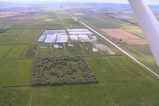
Eldernell near Whittlesey, Cambridgeshire
Winter waterfowl, cranes and birds of prey viewed from the barrier bank
Decide if the visit fits.
Last checked 18 October 2026.
Opening and charges information · checked .
Stay nearby →Reserve overview
Winter waterfowl, cranes and birds of prey viewed from the barrier bank
Eight checks for a smoother visit.
Conditions change: check the operator and transport notices before travelling.
January: Typically use Eldernell Sluice: South Barrier Bank for Snipe and Peregrine. Winter Hen Harrier remains a sensitive target; scan for owls from public routes without seeking a roost or entering the wash.
February: Usually Eldernell Sluice: South Barrier Bank offers the simplest winter watch for Snipe and Peregrine. Water levels change the available feeding ground; choose a sheltered spell rather than treating last week’s report as a forecast.
March: Typically listen for displaying Snipe from South Barrier Bank: eastern public path and check the meadow for Lapwing. Keep to the bank: the flooded fields are habitat and flood storage, not an invitation to explore.
April: Usually spring activity builds across the wash. Scan Lapwing and Black-tailed Godwit from Eldernell Sluice: South Barrier Bank, keeping distance from displaying birds and avoiding any attempt to identify nesting patches.
May: Typically watch for Hobby and Marsh Harrier from Eldernell Sluice: South Barrier Bank. The county club’s actual May 2026 outing also recorded Little Egret and Grey Heron across the wash, without guaranteeing another encounter.
June: Usually watch Hobby over the wetland from South Barrier Bank: western public path and Lapwing from Eldernell Sluice: South Barrier Bank. A telescope helps across the broad meadow, but binoculars are better for a fast fly-past.
July: Typically combine Marsh Harrier from South Barrier Bank: eastern public path with Black-tailed Godwit from Eldernell Sluice: South Barrier Bank. County July reports show passage-wader interest, but pool positions and accessible views vary with water levels.
August: Usually maintain a patient open-bank watch for Hobby and Marsh Harrier from Eldernell Sluice: South Barrier Bank. Black-tailed Godwit can add interest; do not search the reserve interior for a reported bird.
September: Typically look for Marsh Harrier and Snipe from South Barrier Bank: eastern public path. Autumn reports can change quickly, so use the county feed to understand recent conditions without assuming a scarce visitor remains.
October: Usually choose Eldernell Sluice: South Barrier Bank for Snipe and wider raptor scans. Increasing wind and short daylight can make a long bank walk unproductive; the reserve has no hide to retreat into.
November: Typically start with Snipe from South Barrier Bank: western public path and Peregrine across the wash from Eldernell Sluice: South Barrier Bank. Keep sensitive Hen Harrier locations unpublished and do not follow any bird towards cover.
December: Usually a short watch from Eldernell Sluice: South Barrier Bank is sensible for Snipe and Peregrine. Bring warm layers and allow a daylight return; open access does not mean floodwater or exposed paths are safe.
Best conditions: Our choice is a calm clear spell with manageable water levels and enough daylight for the return walk. The bank is exposed and there is no shelter. A telescope is essential for confident distant identification; start with binoculars for raptors in flight. Light and scope ratings are editorial. Never descend onto flooded meadows or seek owl and harrier roosts.
The RSPB charges table checked on 18 October 2026 lists admission and parking as free for adults and children, including non-members. The reserve calendar gives 24-hour access. For a first visit use daylight, especially when water levels are high and the limits of a safe route are easier to judge. Parking is at Eldernell Sluice on the South Barrier Bank, owned by the Environment Agency. The RSPB describes twenty spaces on firm, level hardcore, with no height restrictions or lighting and no locking arrangement. The arrival address is Eldernell Lane, Coates, near Whittlesey, PE7 2DD. Do not park across flood-management access. Check the reserve's latest information, Environment Agency flood warnings and the weather before setting out; a reserve showing open does not establish that every approach or bank path is usable after flooding.
Access times: Reserve: 24-hour reserve access in the RSPB calendar, on the public South Barrier Bank right of way only; obey flood closures. · Hides: No hides, formal viewpoints or shelter: the watching rows describe permitted bank sections, not constructed facilities. · Car park: Environment Agency Eldernell Sluice car park is not locked; unlit, firm hardcore surface. · Dawn access: yes. Operator opening information.
Eldernell is primarily a bank-based watch over a working floodplain. The public South Barrier Bank gives an elevated perspective across grassland that can become a broad winter water body. Start by understanding where the water lies, where birds are feeding and which parts of the landward route remain dry. Avoid any attempt to step through floodwater to reach a better angle. A walk along the bank changes the direction of light across the washes, but a stationary telescope watch may reveal more than continuous walking. Scan the open fields, water margins and air above them in turn. The RSPB highlights snipe throughout the year and cranes outside their breeding season; neither requires approaching private breeding areas. Use only the public bank and obey any temporary barriers or flood-control instructions. Two-hour plan: begin with a long scan from the Eldernell arrival area, then take a modest out-and-back along the bank if the route is dry and unobstructed. Turn early enough to repeat the best section in different light and finish without rushing. If water or mud blocks onward progress, the initial public watch is the whole outing; a shorter safe visit is preferable to creating a new path. Full-day plan: divide the day between two or three patient watches from permitted points on the South Barrier Bank, with a food break back at a secure stopping place. A morning scan can be followed by a longer midday rest and another watch in the afternoon, allowing time for cranes or raptors to move naturally into view. Make route length responsive to the actual conditions and available daylight. Leave the washland itself to its flood-management and wildlife functions, and never use an apparently dry field as a shortcut back.
Use the linked reserve map and directions with current access notices. Species are typical seasonal targets. Light and telescope advice reflects our choice of viewpoint.
The open flood meadow and reed margins viewed from the public bank
Gentle slope onto a flat grassy bank with narrow kissing gates; this is a public path, not a formal platform.
Winter: Snipe, Peregrine, Short-eared Owl
Spring: Snipe, Lapwing, Black-tailed Godwit
Summer: Marsh Harrier, Hobby, Little Egret
Autumn: Snipe, Marsh Harrier, Short-eared Owl
Light: either. Scope: essential.
Changing pools and distant wet grassland from the eastern bank path
Public right of way only; no managed trails, hides or weather shelter. Do not descend onto reserve fields.
Spring: Lapwing, Snipe
Summer: Marsh Harrier, Hobby
Autumn: Marsh Harrier, Snipe
Winter: Snipe, Peregrine
Light: either. Scope: essential.
Washland pools and reedbed edges from the western bank path
Stay on the public South Barrier Bank. Birds range across the wash; no particular pool is guaranteed from either direction.
Spring: Lapwing, Grey Heron, Little Egret
Summer: Hobby, Grey Heron
Autumn: Snipe
Winter: Snipe, Peregrine
Light: either. Scope: essential.
| Spot | Overlooks | Key species by season | Best light | Scope | Tide |
|---|---|---|---|---|---|
| Eldernell Sluice: South Barrier BankGentle slope onto a flat grassy bank with narrow kissing gates; this is a public path, not a formal platform. | The open flood meadow and reed margins viewed from the public bank | Winter: Snipe, Peregrine, Short-eared Owl Spring: Snipe, Lapwing, Black-tailed Godwit Summer: Marsh Harrier, Hobby, Little Egret Autumn: Snipe, Marsh Harrier, Short-eared Owl | either | essential | — |
| South Barrier Bank: eastern public pathPublic right of way only; no managed trails, hides or weather shelter. Do not descend onto reserve fields. | Changing pools and distant wet grassland from the eastern bank path | Spring: Lapwing, Snipe Summer: Marsh Harrier, Hobby Autumn: Marsh Harrier, Snipe Winter: Snipe, Peregrine | either | essential | — |
| South Barrier Bank: western public pathStay on the public South Barrier Bank. Birds range across the wash; no particular pool is guaranteed from either direction. | Washland pools and reedbed edges from the western bank path | Spring: Lapwing, Grey Heron, Little Egret Summer: Hobby, Grey Heron Autumn: Snipe Winter: Snipe, Peregrine | either | essential | — |
Month chips show typical presence or our preferred viewing season. Choose birds that suit the time of your visit.
The RSPB describes a gentle slope onto the South Barrier Bank, followed by flat grass with narrow kissing gates. Those gates can be a decisive restriction for a wheelchair or mobility scooter, while a grass surface can become soft after rain even where the car park remains firm. Confirm the dimensions and current ground conditions with the reserve before choosing a route with a mobility aid. The arrival-area view may allow a shorter outing, but assess the exact position and surface rather than assuming a marked accessible viewpoint exists. An exposed bank can be uncomfortable for someone who needs frequent rests or struggles to stay warm while stationary. A companion can help judge conditions without the whole party committing to the path. The reserve has no toilets; the operator gives Whittlesey, around four miles away, as the nearest public provision. Establish a suitable facilities stop on the landward side of the visit. Keep the return within the distance and conditions everyone can comfortably manage, with particular care when mud, standing water or a strong crosswind changes the effort involved.
There is no staffed visitor centre, café or toilet at the Eldernell watch. Bring drinking water, food and suitable layers for an open-bank visit; Whittlesey is the practical town for supplies and a comfort stop. Binoculars are useful immediately, with a telescope valuable for more distant wildfowl. Carry belongings that can be kept secure in wind and take litter away. This is a working flood landscape, so keep equipment clear of gates, vehicle approaches and other users of the bank.
The South Barrier Bank is used by dog walkers and the RSPB warns that sheep are present. Keep a dog on a short lead around livestock and well away from feeding birds. Assistance dogs may use the adjacent paths. Stay with the public access and take waste home for disposal.
Whittlesea station serves Whittlesey and is the nearest useful railway gateway for Eldernell, with Peterborough offering a wider choice of connecting services. A taxi booked to the Eldernell Sluice public arrival point is the practical final leg for a visitor carrying optics. Arrange collection in advance and give the driver the actual Eldernell Lane destination, rather than the general name of the extensive Nene Washes. A current numbered bus running to the reserve arrival point was not established from the operator information checked. Use the confirmed rail-and-taxi approach rather than relying on a service into Coates to deliver a safe final rural walking connection. A long roadside walk can consume the useful winter light before the birdwatch begins. Cyclists should choose a lawful local-road approach and allow for the return against the wind. Do not assume that a flood bank is a cycle route or that a route shown beside the river remains passable in a flood. Road estimates for the three stay bases refer to the Eldernell arrival point and exclude stops or delays caused by current conditions.
Useful bases for an early start.
Booking.com links are affiliate links: we may earn a commission at no extra cost to you. How these links work.
About 4.0 miles by road, roughly 11 minutes’ drive to the reserve arrival point (OSRM, measured 18 October 2026; an estimate without live traffic).
Measured driving route · 18 October 2026. Map estimates exclude live traffic.
A base in Whittlesey suits a longer break that includes RSPB Nene Washes.Find places to stay in Whittlesey on Booking.comAbout 11.9 miles by road, roughly 25 minutes’ drive to the reserve arrival point (OSRM, measured 18 October 2026; an estimate without live traffic).
Measured driving route · 18 October 2026. Map estimates exclude live traffic.
A base in Peterborough suits a longer break that includes RSPB Nene Washes.Find places to stay in Peterborough on Booking.comAbout 10.4 miles by road, roughly 18 minutes’ drive to the reserve arrival point (OSRM, measured 18 October 2026; an estimate without live traffic).
Measured driving route · 18 October 2026. Map estimates exclude live traffic.
A base in March suits a longer break that includes RSPB Nene Washes.Find places to stay in March on Booking.comExplore Cambridgeshire’s full guides and smaller birding sites
The RSPB publishes 01733 205140 for Nene Washes enquiries and gives Eldernell Lane, Coates, near Whittlesey, Cambridgeshire, PE7 2DD as the visiting address. Use the reserve page for the current access position and contact the team about the South Barrier Bank if flooding or a mobility requirement makes the intended route uncertain. Environment Agency flood information is a separate essential source when river levels are high. Keep breeding-bird observations general and report sensitive detail privately through the operator.
Check Cambridgeshire Bird Club: What’s About dated county sightings. most days Reports show what has been seen, not what will be.
Follow the BTO Birders’ Code and give wildlife space.
RSPB Nene Washes: Free entry and parking.
RSPB Nene Washes: The South Barrier Bank is used by dog walkers and the RSPB warns that sheep are present.
RSPB Nene Washes: Winter flooded washland; spring snipe and marsh birds.
RSPB Nene Washes: Those gates can be a decisive restriction for a wheelchair or mobility scooter, while a grass surface can become soft after rain even where the car park remains firm.
RSPB Nene Washes: Whittlesea station serves Whittlesey and is the nearest useful railway gateway for Eldernell, with Peterborough offering a wider choice of connecting services.
Shorter stops within 15 miles in a straight line. Use the operator’s arrival directions for the journey.
New Road, Whittlesey · Former clay pits, wetland, grassland and scrub
Twenty Foot Road, near March · Disused railway embankment, reedbeds, ponds and scrub
Norwood Road, north of March railway station · Flooded railway borrow pit, marsh and scrub
Hodney Road, northeast Peterborough · Former clay pit, shallow pools, reedbed and scrub
North Street, Stanground, Peterborough · Flooding grassland, riverside ditches and embankment
Crowland Road, south-east of Deeping St James · Flooded gravel pits, lake islands and wetland margins
Great Raveley Drain entrance west of Ramsey Heights · Fen, reedbed, wet woodland, meres and drainage channels
Upwood village, near Ramsey · Traditional clay meadows, hedges and dew ponds
Public bridleway approach north of Ailsworth · Ancient woodland, limestone grassland, scrub and ponds
Station Approach and lake entrance, Somersham · Lake, former railway land, woodland and grassland
B1090 and Woodwalton-road approaches near Woodwalton · Ancient oak, ash and field-maple woodland
Nearby complete guides.
Stops with a purpose: use one as a contrasting habitat or weather-proof Plan B. Distances are straight-line estimates, not road journeys.