

Short entry2.2 miles away
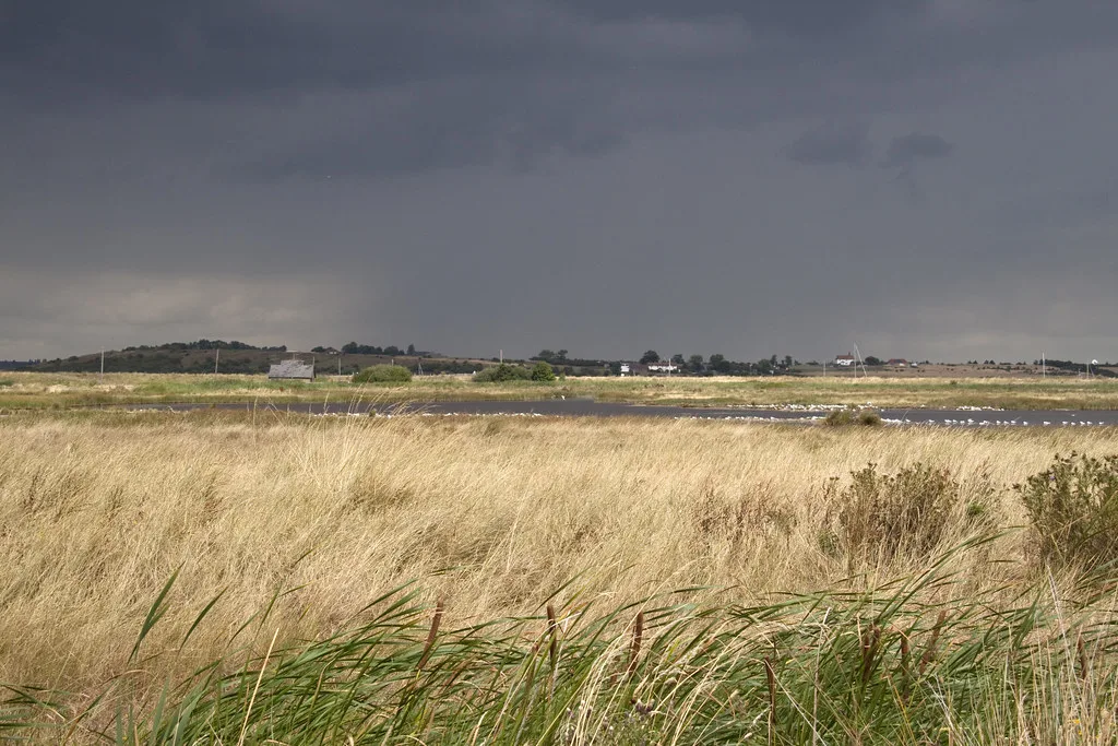
Capel Fleet
Harty · Farmland and wetland
 the ai birderBirding near me
The AI Birder · one-page field sheet
Kent, England · ME13 0QD · ME13 0QD

Avocet · Black-tailed Godwit · Bearded Tit · Redshank · Little Egret · Curlew
East hide · Sea hide · East Flood roadside viewing point · Swale seawall path · West Flood circular path
Check current access, hide closures and operator notices before travelling. Seasonal birds are possibilities, not promised sightings. Keep to authorised routes and give wildlife space.
Opening and charges checked 2026-10-18. Operator: https://www.kentwildlifetrust.org.uk/nature-reserves/oare-marshes
Full guide and current source links: https://aibirder.co.uk/reserves/oare-marshes-nature-reserve
EN 38 · Kent Wildlife Trust reserve guide
Kent, England · ME13 0QD
Avocets, passage waders and winter wildfowl across freshwater floods beside the Swale.
Decide if the visit fits.
Last checked 18 October 2026.
Opening and charges information · checked .
Stay nearby →Reserve overview
Avocets, passage waders and winter wildfowl across freshwater floods beside the Swale.
Eight checks for a smoother visit.
Conditions change: check the operator and transport notices before travelling.
January: Usually start at East hide for Avocet, Dunlin and Snipe, then compare Curlew and Redshank from Sea hide. Plan the flood watch around a daylight high tide and use the seawall for feeding birds on exposed mud. Sheltered observation is more useful than repeatedly putting resting birds up. February: Typically give East hide a slow scan for Dunlin and Snipe before watching the Swale from Sea hide. Kestrel and Marsh Harrier can add interest from the West Flood circular path. On cold days, complete identification from a distance rather than approaching birds that are conserving energy. March: Avocet and Lapwing usually make the East Flood worthwhile from East hide and the roadside viewing point. Scan reed and ditch edges for Water Rail where cover opens naturally along the West Flood circular path. Keep to permitted paths as breeding activity increases. April: Usually watch for Little Ringed Plover from East hide and passage Whimbrel along the Swale seawall path. Give Avocets room on the flood margins and listen before moving between stops. Early morning can help with quieter watching, provided the ground suits your party. May: Our choice is East hide for Avocet and Little Ringed Plover, with Bearded Tit a reed-edge possibility from the East Flood roadside viewing point. Follow the seawall for Common Tern and Yellow Wagtail. Breeding birds should come into view from the path without any approach into cover. June: Typically combine an East hide watch for Avocet and Little Ringed Plover with the seawall for Common Tern. Look for Bearded Tit along visible reed edges from the established roadside position. Stay with distant views if adults call persistently or change their behaviour as people pass. July: Returning Green Sandpiper and Greenshank can make East hide useful as passage begins, while Little Egrets and Cattle Egrets use grazing areas seen from the West Flood circular path. Usually water levels matter more than walking distance. Revisit whichever flood retains productive muddy margins. August: Black-tailed Godwit, Dunlin and passage Greenshank typically reward the East Flood roadside viewing point and East hide. Compare Whimbrel and Redshank from Sea hide on exposed creek mud. A rising tide can move birds back towards the flood; do not crowd their resting place. September: Usually give East hide a sustained look for Spotted Redshank, Little Stint and Curlew Sandpiper among the more numerous waders. These are scarcer targets, so begin by identifying Dunlin and Black-tailed Godwit carefully. Scan the Swale from the seawall for Little and Great White Egrets. October: Watch East Flood from East hide for Dunlin, Snipe and occasional Water Pipit, then compare the Swale from Sea hide. Cattle Egrets may remain with grazing animals seen from the West Flood path. Typically a calm spell gives more useful reed-edge views than a windy circuit. November: Avocet, Dunlin and Snipe usually form useful targets at East hide. Plan a second flood scan close to daylight high water and a Sea hide session for Curlew and Redshank when mud is exposed. Short days favour fewer, longer watches with a telescope. December: Typically combine the level Sea hide approach for Curlew and Redshank with an East Flood scan for Avocet and Dunlin. A West Flood path session may reveal hunting Marsh Harrier or a Water Rail at an open ditch edge. Carry enough insulation for a stationary, exposed watch.
Best conditions: Our choice is a daylight high tide for the flood watch, followed by exposed creek mud as water falls. Typically a calm morning improves reed-edge listening and a cooler part of the day reduces heat shimmer. Scope and light ratings are editorial: compare the established flood views and use the one with the sun behind you. Choose the surfaced Sea hide approach when wet ground prevents the East hide circuit.
Access and charges checked 18 October 2026: Its published charge is for parking: £2.50 on weekdays and £3.50 at weekends. RingGo location 684764 applies, and the Trust’s parking FAQ states a 20p administration charge. Payment can be made by app, online or phone on 02030 460010 and must be completed by 23:59 on the day of the visit. Arrange payment while you have a signal rather than relying on connectivity at the marsh. The reserve page does not list a separate admission ticket or a requirement to book an ordinary walk. Guided experiences have their own bookings and dated prices; they should not be confused with everyday access. Volunteer management work usually takes place on Mondays and Wednesdays and may be noisy. Check the operator’s notices before travelling, especially if wet ground or a particular hide approach will determine whether your visit is possible.
Access times: Reserve: Open at all times on the public circular footpaths. · Hides: No separate hide timetable is listed; the reserve page names East and Sea hides within all-times access. · Car park: Parking is listed with the all-times reserve access; pay the published daily charge. · Dawn access: yes. Operator opening information.
Oare rewards standing still as much as walking. The East Flood can hold a changing mix of resting birds and feeding waders, while the seawall gives a wider view of the Swale and its tidal margins. Kent Wildlife Trust asks visitors to use the circular paths and viewing hides. Carry a map and keep the flood, shoreline and return route in mind rather than following another watcher into an unfamiliar corner. The operator names the east hide and sea hide in its access guidance. Use the hides and established viewing positions to keep your outline away from feeding or roosting flocks. A birdwatching visit can remain quite compact: repeated scans of the same pool often reveal birds that were hidden behind a bank or another flock on the first pass. Avoid climbing onto the bank for a better camera angle if doing so puts resting birds into flight. Two-hour plan — our suggestion: start with a settled East Flood watch, identifying the common ducks and waders before looking for less familiar birds. Move towards the sea-hide view if the path suits your party, compare the estuary with the freshwater flood, then return for a second look at the original flock. Allow enough of the visit for both views instead of using all the time to chase a reported rarity. Full-day plan — our suggestion: arrive for morning light, make an initial flood scan and follow the permitted circular route while observing how the birds use the different waterside areas. Take a packed lunch, then revisit the floods around the most useful part of the tide. Spend the final session where the light is best for identifying the birds already present. This is an editorial watching plan; there is no promise that a particular tide will produce the same gathering every day. For a longer approach, Explore Kent publishes a separate five-mile circular walk beginning in Oare village. That is a wider outing with gates and steps, not the distance of the short reserve watch described here. Keep dogs, optics and other equipment close when sharing a narrow path. The muddy shore and ditches are wildlife habitat, not shortcuts between viewpoints.
Use the linked reserve map and directions with current access notices. Species are typical seasonal targets. Light and telescope advice reflects our choice of viewpoint.
East Flood, wet margins and bordering reeds
Wet conditions can prevent the full circuit to this hide; the operator describes access as seasonal.
Winter: Avocet, Dunlin, Snipe
Spring: Avocet, Little Ringed Plover
Summer: Little Ringed Plover, Bearded Tit
Autumn: Black-tailed Godwit, Spotted Redshank, Little Stint, Curlew Sandpiper
Light: either. Scope: useful.
Tide: High water can bring shore birds onto the floods; freshwater levels still determine usable feeding margins.
Swale and Faversham Creek mudflats
The operator describes a level compacted-roadstone approach and RADAR gates.
Winter: Curlew, Redshank, Dunlin
Spring: Avocet, Ringed Plover
Summer: Shelduck, Little Egret
Autumn: Black-tailed Godwit, Whimbrel
Light: either. Scope: essential.
Tide: Falling water exposes feeding mud; compare the floods as the rising tide covers it.
East Flood from the established lane-side viewing area
Use the established viewing position without obstructing the lane.
Winter: Avocet, Snipe
Spring: Avocet
Summer: Bearded Tit, Lapwing
Autumn: Black-tailed Godwit, Greenshank, Dunlin
Light: either. Scope: useful.
Tide: Give the flood another scan near high water.
Swale, tidal creeks and grazing margins from the public seawall route
Winter: Curlew, Peregrine
Spring: Whimbrel, Ringed Plover
Summer: Common Tern, Yellow Wagtail
Autumn: Little Egret, Great White Egret, Black-tailed Godwit
Light: either. Scope: essential.
Tide: Choose exposed mud for feeding birds and keep to the seawall as the tide rises.
West Flood, reed-fringed ditches and grazing marsh from the circular path
Stay on the circular footpaths; cattle graze throughout the year.
Winter: Water Rail, Marsh Harrier
Spring: Marsh Harrier
Summer: Little Egret, Cattle Egret
Autumn: Water Rail, Cattle Egret, Kestrel
Light: either. Scope: useful.
| Spot | Overlooks | Key species by season | Best light | Scope | Tide |
|---|---|---|---|---|---|
| East hideWet conditions can prevent the full circuit to this hide; the operator describes access as seasonal. | East Flood, wet margins and bordering reeds | Winter: Avocet, Dunlin, Snipe Spring: Avocet, Little Ringed Plover Summer: Little Ringed Plover, Bearded Tit Autumn: Black-tailed Godwit, Spotted Redshank, Little Stint, Curlew Sandpiper | either | useful | High water can bring shore birds onto the floods; freshwater levels still determine usable feeding margins. |
| Sea hideThe operator describes a level compacted-roadstone approach and RADAR gates. | Swale and Faversham Creek mudflats | Winter: Curlew, Redshank, Dunlin Spring: Avocet, Ringed Plover Summer: Shelduck, Little Egret Autumn: Black-tailed Godwit, Whimbrel | either | essential | Falling water exposes feeding mud; compare the floods as the rising tide covers it. |
| East Flood roadside viewing pointUse the established viewing position without obstructing the lane. | East Flood from the established lane-side viewing area | Winter: Avocet, Snipe Spring: Avocet Summer: Bearded Tit, Lapwing Autumn: Black-tailed Godwit, Greenshank, Dunlin | either | useful | Give the flood another scan near high water. |
| Swale seawall path | Swale, tidal creeks and grazing margins from the public seawall route | Winter: Curlew, Peregrine Spring: Whimbrel, Ringed Plover Summer: Common Tern, Yellow Wagtail Autumn: Little Egret, Great White Egret, Black-tailed Godwit | either | essential | Choose exposed mud for feeding birds and keep to the seawall as the tide rises. |
| West Flood circular pathStay on the circular footpaths; cattle graze throughout the year. | West Flood, reed-fringed ditches and grazing marsh from the circular path | Winter: Water Rail, Marsh Harrier Spring: Marsh Harrier Summer: Little Egret, Cattle Egret Autumn: Water Rail, Cattle Egret, Kestrel | either | useful | — |
Month chips show typical presence or our preferred viewing season. Choose birds that suit the time of your visit.
Be settled at a flood viewpoint around daylight high water, when the Trust says birds use the scrapes for feeding and resting. Falling water exposes feeding mud along the Swale and creeks. Stay on the seawall and paths.
Kent Wildlife Trust describes Oare as seasonally accessible for wheelchair users. In wet conditions, it says a complete circuit to the east hide is not possible. The route to the sea hide has a level surface of compacted roadstone and there are RADAR gates. Those distinctions matter more than the marsh’s generally flat appearance: a firm approach to one viewing place does not imply that every path beyond it has the same surface. Before travelling, discuss the route you need with the Trust, including gate operation, the recent weather and your chair or walking aid. Choose a specific outward-and-return option if a full circuit would be too uncertain. A modest distance can still allow a substantial watch over the floods and estuary, so concentrate on the quality of the viewing position rather than the length of the walk. Pack weather protection that works while stationary in an exposed location, as well as what you need for moving along the path. A companion should know the intended turnaround point and the remaining effort needed for the return. The Trust does not give detailed doorway dimensions or a complete hide-access specification on the reserve page; request those details before setting out if they are essential. Do not substitute the much longer village circular walk for an access-assessed reserve approach.
This is a marsh outing centred on hides, parking and outdoor watching. Bring food, drinking water and enough warm clothing for a prolonged stationary watch rather than assuming there is a staffed refreshment stop. The Trust lists bicycle parking but asks visitors not to cycle along the narrow public right of way. Cattle graze the reserve throughout the year, so give them space and leave gates as directed. Carry a bag for litter and keep tripods out of the main passage through a hide or gateway.
Dogs must remain on a lead and on the public right of way throughout the year. Kent Wildlife Trust specifically asks owners to keep dogs out of water, ditches and saltmarsh to protect habitat and wildlife. Keep close control around the grazing cattle, remove dog waste and choose a route that lets other visitors pass without crowding birds at a viewpoint.
Faversham is the useful railway gateway for Oare. A pre-booked taxi from the station is the simplest onward connection when you want to reach the marsh rather than add a longer walk from the village. Give the driver the reserve on Church Road and arrange a return collection; the village itself and the birdwatching parking area are different destinations. Faversham Town Council publishes the Hopper community-bus timetable serving Oare. Its September 2025 schedule identifies FH1 on Wednesdays and FH2 on Tuesdays, Thursdays and Fridays, with Oare and Faversham Railway Station among the stops. Check the council’s latest timetable before choosing this option: it is a limited-day village connection, not a daily bus to the hides. Leave time for the remaining approach and its suitability for your party. Do not plan a late finish around a bus without checking the final return trip. For walkers, the council-backed Explore Kent route starts in Oare and offers a longer circular approach. Drivers should follow the reserve’s Church Road location and avoid blocking access along the lane. The three nearby stay bases below use measured road journeys to the marsh, with no allowance for live traffic.
Useful bases for an early start.
Booking.com links are affiliate links: we may earn a commission at no extra cost to you. How these links work.
About 2.9 miles by road, roughly 7 minutes’ drive; OSRM estimate measured 18 October 2026, without live traffic.
Measured driving route · 2026-10-18. Map estimates exclude live traffic.
A nearby town and railway station for an early marsh visit.Find places to stay in Faversham on Booking.comAbout 12.1 miles by road, roughly 20 minutes’ drive; OSRM estimate measured 18 October 2026, without live traffic.
Measured driving route · 2026-10-18. Map estimates exclude live traffic.
A coastal stay for combining the Swale marshes with shore watching.Find places to stay in Whitstable on Booking.comAbout 13.0 miles by road, roughly 21 minutes’ drive; OSRM estimate measured 18 October 2026, without live traffic.
Measured driving route · 2026-10-18. Map estimates exclude live traffic.
A city base with wider rail connections and an evening choice of restaurants.Find places to stay in Canterbury on Booking.comExplore Kent’s full guides and smaller birding sites
Kent Wildlife Trust gives 01622 662012 as the contact number for Oare Marshes. Use the reserve page for the current warden contact link and describe the date, route or facility you need help with. Its address is Church Road, Oare, Faversham, ME13 0QD; the page also supplies what3words roughness.herring.watching. Save those details alongside your map before leaving. For questions about the Hopper bus, use the separate council contact hopper@favershamtowncouncil.gov.uk rather than expecting the reserve team to manage transport bookings.
Check Kent Ornithological Society: Oare and county reports. as submitted; newest seven days require membership Reports show what has been seen, not what will be.
Follow the BTO Birders’ Code and give wildlife space.
Oare Marshes Nature Reserve: Parking £2.50 weekdays / £3.50 weekends, plus stated 20p RingGo administration charge.
Oare Marshes Nature Reserve: Dogs must remain on a lead and on the public right of way throughout the year.
Oare Marshes Nature Reserve: Autumn passage waders · winter wildfowl · spring marsh birds.
Oare Marshes Nature Reserve: Kent Wildlife Trust describes Oare as seasonally accessible for wheelchair users.
Oare Marshes Nature Reserve: Faversham is the useful railway gateway for Oare.
Shorter stops within 15 miles in a straight line. Use the operator’s arrival directions for the journey.
Harty · Farmland and wetland
Rough Common · Woodland
Wye Downs, near Wye · Chalk grassland, woodland and hedgerows
Shoebury Common Road, Shoeburyness · Coastal grassland, pond, remnant dunes and estuary edge
Stodmarsh village, near Canterbury · Reedbeds, lakes, grazing marsh and wet woodland
Nearby complete guides.
Stops with a purpose: use one as a contrasting habitat or weather-proof Plan B. Distances are straight-line estimates, not road journeys.