
Short entry1.1 miles away
Walsey Hills
Between Cley-next-the-Sea and Salthouse · woodland · scrub · coast
 the ai birderBirding near me
The AI Birder · one-page field sheet
North Norfolk coast, Norfolk, England · Cley Beach walking entrance NR25 7RY · NR25 7RY

Current planning alert (2026-10-18): A Norfolk Coast Path diversion is published at Morston while embankment repairs take place. Follow the signed alternative and check the National Trust route notice before planning a mainland coastal walk.
Oystercatcher · Redshank · Shelduck · Meadow Pipit · Skylark · Linnet
Cley Beach (Point walk start) · Watch House section of the public shingle walk · Boardwalk crest near the Lifeboat House · Lifeboat House public approach
Check current access, hide closures and operator notices before travelling. Seasonal birds are possibilities, not promised sightings. Keep to authorised routes and give wildlife space.
Opening and charges checked 2026-10-18. Operator: https://www.nationaltrust.org.uk/visit/norfolk/blakeney-national-nature-reserve
Full guide and current source links: https://aibirder.co.uk/reserves/blakeney-point
EN 66 · National Trust reserve guide
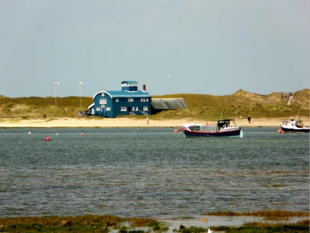
North Norfolk coast, Norfolk, England · Cley Beach walking entrance NR25 7RY
Harbour boat views of seals and terns, with a separate long shingle walk.
Decide if the visit fits.
Last checked 18 October 2026.
A Norfolk Coast Path diversion is published at Morston while embankment repairs take place. Follow the signed alternative and check the National Trust route notice before planning a mainland coastal walk.
Opening and charges information · checked .
Stay nearby →Reserve overview
Harbour boat views of seals and terns, with a separate long shingle walk.
Eight checks for a smoother visit.
Conditions change: check the operator and transport notices before travelling.
January: a short Cley Beach watch can provide Oystercatcher and Shelduck opportunities without undertaking the full Point walk. Seal-pupping restrictions can shorten or close the farther route, so do not assume access to the boardwalk. February: compare Meadow Pipit, Linnet and Reed Bunting along the permitted Watch House section. Choose calm conditions and retain enough daylight for the slow shingle return. March: Skylark song typically gives the public shingle walk a spring character. Watch from the Watch House route and respect newly installed fences before the main nesting season. April: Shelduck and Oystercatcher can be watched from Cley Beach and other permitted coastal views. From the Watch House section, listen for Skylark and Reed Bunting without searching the vegetation for nests. May: use the permitted Watch House section for Meadow Pipit and Linnet. Terns are a seasonal reason to visit, but view feeding flights from public routes or operator-run boats and never enter a colony. June: the boardwalk crest, when open, gives a public dune panorama for Skylark and Meadow Pipit. Stick to the marked endpoint; breeding birds are not a reason to cross fencing. July: Cley Beach and the Watch House stretch usually offer Oystercatcher, Linnet and Meadow Pipit. Keep any tern watching to feeding birds from approved public views, with no nest directions. August: the Lifeboat House public approach can add Stonechat and Wren when access permits. Check current restrictions rather than assuming the earliest date in an older walk leaflet applies. September: Stonechat, Meadow Pipit and Linnet give a practical baseline along the Watch House route. Migration can add surprises, but choose the route for its habitats rather than a promise of rare birds. October: choose the Watch House section for Reed Bunting and Meadow Pipit in a workable weather window. From late month, seal activity can alter access towards the Lifeboat House. November: a Cley Beach Oystercatcher watch and a shorter permitted shingle walk for Linnet avoid committing to a closed farther route. Check pup-season signs before proceeding towards the dunes. December: use the safest open Cley Beach section for Oystercatcher and Shelduck, with Meadow Pipit along nearby permitted shingle. Rough surf, a high tide or seal restrictions can make a mainland alternative the better outing.
Best conditions: Usually choose a settled, lighter-wind day for the long shingle walk and a clear view of sea and harbour. Onshore wind and high water can remove the easier beach strip; do not continue when surf or flooding threatens the return. Light and scope choices are editorial; migrants are possible rather than promised.
Access and prices checked on 18 October 2026: there is no separate reserve admission tariff on the National Trust visitor page, but parking and boat trips are separate costs. At Morston Quay, non-member parking costs £4 for up to three hours or £6 all day; National Trust members obtain a free ticket by scanning their card or using the stated JustPark arrangement. Lower Quay parking can flood on spring tides. The public shingle walk starts at Cley Beach, whose car park is managed by Norfolk Wildlife Trust with its own charge and membership rules. National Trust membership does not automatically cover that parking. Opening and building access are shown separately in Access times. Check coast-path notices, weather, tides and any boat confirmation before travelling. Never cross flooded parking or marsh ground to reach a departure.
Access times: Reserve: National Trust calendar: dawn to dusk; seasonal wildlife closures override the general opening window. · Hides: No public bird-hide inventory is listed. The Lifeboat House building is separate and was listed closed on the October calendar checked. · Car park: Morston Quay car park: dawn to dusk. Cley Beach is a separately managed Norfolk Wildlife Trust car park; check its own conditions. · Dawn access: partly. Operator opening information.
Choose between the Morston boat outing and the substantial walk along the shingle from Cley Beach. They are different ways to experience the Point, and combining both in a short visit is unrealistic. The NT describes the beach route as approximately seven miles return to the dunes near the Lifeboat House, with much of the walking on loose shingle. Seasonal fencing protects nesting birds and seals. The boat service gives a harbour-side wildlife view without committing to that long return walk. Two-hour plan, editorial suggestion: arrive at Morston in time for the booked departure, scan the creeks while waiting and take the approximately hour-long trip. Use the remaining time for a short mainland viewpoint watch and a drink if the café is operating. Do not add an expectation of landing or walking to the colony to this compact boat-based itinerary. Full-day plan, editorial suggestion: build the day around a confirmed boat trip, with mainland saltmarsh watching before or afterwards. Add a separately chosen section of the coastal path or the Blakeney Freshes route if the posted diversion and your travel connections permit. Alternatively, make the Cley Beach shingle walk the day's main activity, packing food and using only the permitted route. Keep the return within daylight and retain the energy needed for the difficult surface. Do not attempt to walk across Blakeney Harbour to reach the Point. Creeks, soft mud and the tide make apparent shortcuts dangerous. On the beach, obey the fence lines and the NT team's instructions; the visible colony is not an invitation to step closer. Watching from a boat also calls for restraint: remain seated or positioned as instructed, keep lenses and binoculars under control and let the skipper manage the wildlife approach. A tern carrying food may cross the harbour repeatedly, so study its route from a permitted position rather than following it towards a nest. The mapped point marks the genuine Cley Beach walking entrance, while Morston Quay is the separate boat departure.
Use the linked reserve map and directions with current access notices. Species are typical seasonal targets. Light and telescope advice reflects our choice of viewpoint.
Shingle beach, sea and vegetated ridge
Start at the public Cley Beach car park; stay outside all roped areas.
Winter: Oystercatcher, Shelduck
Spring: Oystercatcher, Meadow Pipit
Summer: Oystercatcher, Linnet
Autumn: Oystercatcher, Linnet
Light: either. Scope: essential.
Vegetated shingle, low scrub and saltmarsh-facing views
Public route only; nesting birds may lead to local diversions.
Winter: Meadow Pipit, Linnet, Reed Bunting
Spring: Skylark, Meadow Pipit, Reed Bunting
Summer: Meadow Pipit, Linnet, Skylark
Autumn: Stonechat, Meadow Pipit, Linnet
Light: either. Scope: useful.
Dunes and surrounding coast from the official walk endpoint
Only when the signed route is open; do not continue west beyond restrictions.
Winter: Shelduck, Oystercatcher
Spring: Meadow Pipit, Linnet
Summer: Meadow Pipit, Skylark
Autumn: Stonechat, Meadow Pipit
Light: either. Scope: essential.
Low scrub and dune edge beside the permitted route
The building and approach have separate access; a closed house is not permission to pass closure signs.
Winter: Wren, Dunnock
Spring: Wren, Dunnock
Summer: Wren, Stonechat
Autumn: Stonechat, Dunnock
Light: either. Scope: not needed.
| Spot | Overlooks | Key species by season | Best light | Scope | Tide |
|---|---|---|---|---|---|
| Cley Beach (Point walk start)Start at the public Cley Beach car park; stay outside all roped areas. | Shingle beach, sea and vegetated ridge | Winter: Oystercatcher, Shelduck Spring: Oystercatcher, Meadow Pipit Summer: Oystercatcher, Linnet Autumn: Oystercatcher, Linnet | either | essential | — |
| Watch House section of the public shingle walkPublic route only; nesting birds may lead to local diversions. | Vegetated shingle, low scrub and saltmarsh-facing views | Winter: Meadow Pipit, Linnet, Reed Bunting Spring: Skylark, Meadow Pipit, Reed Bunting Summer: Meadow Pipit, Linnet, Skylark Autumn: Stonechat, Meadow Pipit, Linnet | either | useful | — |
| Boardwalk crest near the Lifeboat HouseOnly when the signed route is open; do not continue west beyond restrictions. | Dunes and surrounding coast from the official walk endpoint | Winter: Shelduck, Oystercatcher Spring: Meadow Pipit, Linnet Summer: Meadow Pipit, Skylark Autumn: Stonechat, Meadow Pipit | either | essential | — |
| Lifeboat House public approachThe building and approach have separate access; a closed house is not permission to pass closure signs. | Low scrub and dune edge beside the permitted route | Winter: Wren, Dunnock Spring: Wren, Dunnock Summer: Wren, Stonechat Autumn: Stonechat, Dunnock | either | not needed | — |
Month chips show typical presence or our preferred viewing season. Choose birds that suit the time of your visit.
The National Trust suggests the exposed beach as an easier walking surface when the tide is out; use the shingle route only when safe and permitted. Check Blakeney Bar predictions, surf and the whole return journey before the long walk. Keep to the public route and never cross the harbour or creeks as a shortcut; no minimum height or fixed high-water watch is asserted.
Operator: Beans Boat Trips, Bishop’s Boats, Ptarmigan Seal Trips and Temples Seal Trips from Morston Quay.
Booking opens: Book directly with the selected company in advance. Beans currently books by telephone on 01263 740505; the confirmation supplies departure and ticket collection details.. Season: Beans runs throughout the year, with regular winter sailings; Ptarmigan advertises April–early November. Other operators publish their own seasonal and tide-dependent calendars.. Fares: Beans prices checked October 2026: adult £20, children aged 14 and under £10. These are that operator’s fares, not a common tariff for all four businesses.; landing fee: No landing is promised: the current NT reserve page describes seal-viewing trips with no landing available..
Time ashore: Approximately one hour afloat for the usual trip. Plan a separate mainland walk; shore time on the Point is not included in this itinerary.. Landing access: Agree boarding needs with the boat company. The specially adapted Wheelyboat Poppy is a separate accessible option listed by the NT.. Weather policy: Departures follow the tide and safe weather. Beans asks passengers to arrive 30 minutes before the booked sailing; follow your chosen skipper’s confirmation.
The Point's soft shingle is difficult walking and the NT does not recommend its beach route for pushchairs. This is an exposed, isolated destination, so a flat line on a map should not be read as an easy wheeled route. Morston offers a different starting point, with two designated parking spaces, accessible outdoor seating and an accessible toilet, though tidal flooding can affect the ground. Standard seal boats require boarding and disembarking, and the level of help available depends on the operator and vessel. Describe any mobility aid, transfer requirement and balance concern before buying tickets. The NT lists the specially designed Wheelyboat Poppy as a separate option for visitors with disabilities; its published total passenger-weight limit includes the wheelchair, so agree your specific party and equipment with that service. A boat view does not provide accessible landing on the Point. For a land-based alternative, the NT identifies a wheelchair-accessible coastal route around Blakeney Freshes. Select that separate itinerary if it offers a more comfortable day than the beach or boat arrangements.
Morston Quay has toilets and a takeaway café serving drinks, cakes, sandwiches and snacks. The boat operators advise leaving extra time for the facilities before boarding. Carry your own water and lunch on the long Cley Beach walk, and take all rubbish away. The NT's Point pages contain differing wording about a seasonal toilet and the nearest quay facilities; plan toilet stops on the mainland and confirm any Point-side provision directly before relying on it during a long outing.
The current NT reserve page excludes dogs from Blakeney Point from 1 April to 31 August and from 1 November to mid-January. Its older coastal-walk text ends the summer restriction on 15 August, so follow the longer current restriction and on-site signs. Boat dog policies are separate: confirm with the chosen operator before booking.
Sanders Coaches Coasthopper CH1 runs through Morston, Blakeney and Cley between Wells-next-the-Sea and Cromer, with Sheringham providing a useful rail connection. For a boat trip alight in Morston village and follow the signed walk to the quay, described by the NT as about five minutes. Arrange the bus journey around the confirmed tide-dependent departure and allow time for the boarding instructions rather than selecting a boat merely because it appears close to a scheduled bus arrival. For the Cley walking approach, CH1 serves the village; the NT describes an additional mile along Beach Road to the coastal car park. This is distinct from Morston, so check which starting point your plan requires before buying transport. Drivers reach both places from the A149. The measured stays below use Morston Quay for the boat-based visit, with the Cley Beach entrance shown on the map for the separate shingle walk.
Useful bases for an early start.
Booking.com links are affiliate links: we may earn a commission at no extra cost to you. How these links work.
About 1.9 miles by road, roughly 6 minutes’ drive to Morston Quay for the boat (OSRM estimate measured 18 October 2026).
Measured driving route · 18 October 2026. Map estimates exclude live traffic.
A nearby village base east of Morston.Find places to stay in Blakeney on Booking.comAbout 6.7 miles by road, roughly 12 minutes’ drive to Morston Quay for the boat (OSRM estimate measured 18 October 2026).
Measured driving route · 18 October 2026. Map estimates exclude live traffic.
An inland town base for a varied north-coast visit.Find places to stay in Holt on Booking.comAbout 6.7 miles by road, roughly 13 minutes’ drive to Morston Quay for the boat (OSRM estimate measured 18 October 2026).
Measured driving route · 18 October 2026. Map estimates exclude live traffic.
A harbour base west of the departure quay.Find places to stay in Wells-next-the-Sea on Booking.comExplore Norfolk’s full guides and smaller birding sites
National Trust Norfolk Coast can be contacted on 01263 740241 or norfolkcoast@nationaltrust.org.uk. Its Friary Farm office address is explicitly marked as having no public access, so use the visitor entrances rather than driving there. Book seal trips with the boat company itself; the National Trust lists recognised local operators but does not run their sailings. Give your intended date, party and access requirements when asking a skipper about a trip, and keep that operator's departure confirmation available.
Check National Trust Point breeding report, 2025. annual historical field report; not current sightings Reports show what has been seen, not what will be.
Follow the BTO Birders’ Code and give wildlife space.
Blakeney Point: Morston parking £4/3h or £6/day; NT members free; boat fares extra.
Blakeney Point: The current NT reserve page excludes dogs from Blakeney Point from 1 April to 31 August and from 1 November to mid-January.
Blakeney Point: Summer terns · winter seals and wildfowl.
Blakeney Point: Morston offers a different starting point, with two designated parking spaces, accessible outdoor seating and an accessible toilet, though tidal flooding can affect the ground.
Blakeney Point: Sanders Coaches Coasthopper CH1 runs through Morston, Blakeney and Cley between Wells-next-the-Sea and Cromer, with Sheringham providing a useful rail connection.
Shorter stops within 15 miles in a straight line. Use the operator’s arrival directions for the journey.
Between Cley-next-the-Sea and Salthouse · woodland · scrub · coast
Blakeney · wetland · grassland · scrub
Morston · coast · wetland
Meadow Lane approach from Kelling village · Coastal grazing marsh, pool, hedges and shingle shore
Kelling · woodland · heathland · coast
Near Kelling and Weybourne · heathland · woodland · scrub
Weybourne Hope · coast · grassland
Between Weybourne station and Sheringham Park · woodland · heathland
Holt · Woodland
Stiffkey · coast · wetland
Holt, reached through Holt Country Park · Heathland · Woodland
Lower Bodham, between High Kelling and Hempstead · wetland · woodland
Thornage, near Holt · grassland · woodland · wetland
West of Sheringham · coast · grassland
Upper Sheringham · woodland · grassland
Sheringham · Cemetery trees, shrubs, grassland and neighbouring open ground
Sheringham · coast
Briningham · grassland · woodland
Sheringham · Woodland
Edgefield · wetland · grassland · woodland
Sheringham, Norfolk · Coast · Grassland · Scrub
Between Sheringham and Beeston Regis · wetland · grassland · woodland
West Runton · coast · grassland
Northeast of Fakenham, beside the A148 · Woodland
Matlaske and Barningham Park · wetland · woodland · grassland
Lower Gresham · Arable farmland, hedgerows and beck
Roman Camp, West Runton, Norfolk · Heathland · Woodland
Between East and West Runton, Norfolk · Heathland · Scrub · Grassland
Aylmerton · Village pond, reedbed and waterside vegetation
Near Little Snoring, northeast of Fakenham · Woodland · Heathland
East Runton, west of Cromer · Coast · Woodland
Felbrigg, near Cromer · woodland · wetland · grassland
Between Saxthorpe and Little Barningham · woodland
Southwest of Cromer · grassland · woodland
Sustead · wetland · grassland · woodland
Mannington, near Itteringham · woodland · wetland · grassland
Cromer · coast
Near Fakenham · wetland · woodland · grassland
Cromer, Norfolk · Coast · Scrub · Grassland
Heydon · Historic parkland, woodland, meadows and pond
Erpingham · Wet grassland, fen, scrub and ponds
Overstrand · coast
Sculthorpe, near Fakenham · wetland · woodland · grassland
Blickling, near Aylsham · woodland · wetland · grassland
Foxley, northwest of Norwich · Woodland
Off Burnham Overy Staithe · coast · wetland
Aylsham · Nursery gardens, hedgerows, wet meadows and woodland edges
Booton, near Reepham · wetland · grassland · woodland
Lower Southrepps, near Gunton station · Reedbeds · Woodland · Grassland
Suffield · woodland
Nearby complete guides.
Stops with a purpose: use one as a contrasting habitat or weather-proof Plan B. Distances are straight-line estimates, not road journeys.