
Short entry6.4 miles away
Whisby Nature Park
Moor Lane, Thorpe-on-the-Hill, near Lincoln · Lakes, reedbeds, willow scrub and woodland
 the ai birderBirding near me
The AI Birder · one-page field sheet
Collingham near Newark-on-Trent, Nottinghamshire · NG23 7QL

Bittern · Great White Egret · Cattle Egret · Pintail · Wigeon · Kingfisher
Corfe Castle 360 Viewing Area · Olaf the Oak viewpoint · Floating Bridge and Boardwalk · North Trail public reedbed edge · Public perimeter path overlooking Phase 3 · Woodland and Silt Lagoons approach · Outfall Sluice path section
Check current access, hide closures and operator notices before travelling. Seasonal birds are possibilities, not promised sightings. Keep to authorised routes and give wildlife space.
Opening and charges checked 2026-10-18. Operator: https://www.rspb.org.uk/days-out/reserves/langford-lowfields
Full guide and current source links: https://aibirder.co.uk/reserves/rspb-langford-lowfields
EN 89 · RSPB reserve guide
Collingham near Newark-on-Trent, Nottinghamshire
Bitterns, Marsh Harriers, warblers and winter wildfowl
Decide if the visit fits.
Last checked 18 October 2026.
Opening and charges information · checked .
Stay nearby →Reserve overview
Bitterns, Marsh Harriers, warblers and winter wildfowl
Eight checks for a smoother visit.
Conditions change: check the operator and transport notices before travelling.
January: Use Corfe Castle's official viewing area for winter Bittern and Wigeon, then the public reedbed edge for another angle. A Starling gathering is a possibility rather than an appointment. Keep the reserve's dusk closing boundary and the separate walk back to the car park in mind.
February: A calm watch from Corfe Castle or the North Trail gives the reedbed time to reveal a Bittern. Flooding can leave paths eroded or closed, so check signs before crossing the floating section. Barn Owl has no published resting or nesting spot.
March: Typically reedbed breeding activity begins to change the sound of the visit. Listen for Bittern from the North Trail and watch the wetland sky for Marsh Harrier. The seasonal route to Olaf the Oak is not assumed open during the breeding season.
April: Use the North Trail reedbed edge for Bittern and Marsh Harrier. The floating crossing offers a different angle only if conditions and your mobility allow it. A bird's movement through reeds is not an invitation to leave the public path or approach its hidden breeding area.
May: Typically Hobby joins the wetland watching. Pause at Corfe Castle's 360 view to scan the air, then listen from the North Trail for Bittern. The bridge and boardwalk are unsuitable for mobility scooters according to the operator; choose the longer permitted route instead.
June: Corfe Castle offers a useful settled watch for Hobby and Marsh Harrier. The North Trail provides a wider reedbed circuit for Bittern. Reserve-wide occurrence does not guarantee which side a bird will appear, so favour patient scanning over chasing reported positions.
July: Try Corfe Castle for Hobby and use the North Trail for Marsh Harrier. This is still breeding-season habitat: the seasonal route remains subject to signs. Do not enter Phase 3 or the active quarry even when an appealing bird is visible beyond the public route.
August: Hobby and Marsh Harrier are typical summer aims from the official viewing area and North Trail. The Seasonal Trail usually opens after breeding in August, but check current signs before using it. An opened route provides a view, not permission to approach every pool.
September: Start with a broad assessment from Corfe Castle and check which trails are open after management or weather. The October egret and duck records are not a September forecast. Use current county observations before choosing the long perimeter walk towards the Phase 3 view.
October: Compare the Corfe Castle reedbed view with the public perimeter view over Phase 3 for Pintail, Golden Plover or Whooper Swan. October operator records also verify Great White and Cattle Egrets. Look from the seasonal Olaf viewpoint only when its trail is open; never enter the restricted wetland.
November: Typically autumn Bearded Tit watching rewards patience at Corfe Castle's reedbed view before another scan for Bittern. Starling gatherings can develop in winter, but their location and strength vary. Use official public positions and leave the reserve within its dusk access limit.
December: A shorter winter plan can centre on Corfe Castle and the North Trail for Bittern. If Starlings gather, remain at official visitor positions rather than approaching their resting habitat. Mud, floodwater and short daylight may make a simple out-and-back more practical than completing every trail.
Best conditions: Typically a calm morning makes reedbed listening easier and offers steadier scope views. Watch the sky from Corfe Castle for Hobby or Marsh Harrier; choose the safe side of the screen with the light behind or to one side. Severe winter flooding can erode the approach and make mown trails slippery, so route condition takes priority over a planned circuit.
Langford Lowfields rewards a decision between a short reedbed watch and a longer walk around a developing wetland. The approach from the car park is part of the visit, rather than an immediate step into a hide. Once at the visitor entrance, Corfe Castle offers a useful place to stop, scan the water and watch the air above the reeds. The North Trail gives a broader circuit, while the Cromwell route uses the floating crossing. Choose according to conditions and mobility: flood damage, uneven grass and a narrow or slippery section can change what is practical. The seasonal route provides another perspective after breeding, including the mapped Olaf the Oak viewpoint. Birds reported on Phase 3 remain beyond its public boundary, so use only the perimeter view. The aim is to make patient use of the permitted views, rather than reach every reported bird.
Access times: Reserve: Dawn–dusk, as shown on the current RSPB calendar; check flood and management closures. · Hides: Corfe Castle is a 360 viewing screen area. Beach Hut opens most days subject to volunteer availability; no continuous staffed opening promise. · Car park: Dawn–dusk, separately listed by RSPB. Allow for the 800 m approach walk. · Dawn access: yes. Operator opening information.
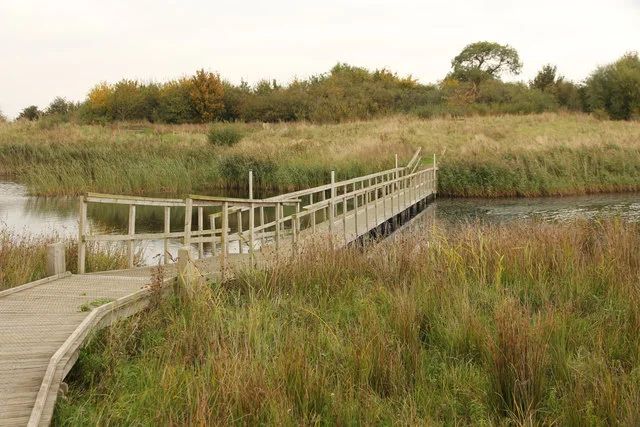
The reserve begins with an approach walk from the car park towards the Beach Hut welcome point. That transition helps explain Langford's character: it is a growing restored wetland rather than a compact centre-and-hide attraction. Use the current RSPB trail map to find the visitor route and distinguish public paths from the areas managed primarily for wildlife. The mown Visitor Trail provides views of reedbed and open water. A floating bridge and boardwalk offer a closer perspective where open and suitable for the visitor, while the surrounding footpath network gives broader views across the developing habitat. Watch for birds moving along the edge between reeds and water. A prolonged quiet stop often reveals more than repeatedly crossing the bridge in pursuit of a sighting. Two-hour plan: allow the first part of the visit for the approach and orientation at the Beach Hut. Choose one section of the visitor trail with good light, spend a substantial watch there and return without trying to reach every part of the wetland. A short visit is most satisfying when the access walk is included in the time budget. Full-day plan: make a careful morning circuit of the available visitor route, listening for reedbed birds and studying the open-water flock. Bring lunch and take a proper break before choosing an afternoon viewpoint. In spring, listen again as wind conditions change; in autumn and winter, compare waders and ducks and assess any late gathering from an authorised position. Flooding can alter both the route and its surfaces, so shorten the plan if the signed network cannot be followed comfortably. Do not cross inundated or closed sections to complete a circuit.
Use the linked reserve map and directions with current access notices. Species are typical seasonal targets. Light and telescope advice reflects our choice of viewpoint.
Phase 1 water, reedbed and open sky
Official seating/view screen; remain inside the permitted trails.
Winter: Bittern, Wigeon, Barn Owl
Spring: Bittern, Marsh Harrier
Summer: Hobby, Marsh Harrier
Autumn: Great White Egret, Pintail, Wigeon, Barn Owl
Autumn: Bearded Tit
Light: either. Scope: useful.
Phase 2 reedbed and open water from the seasonal visitor trail
Seasonal Trail opens after breeding season in August; follow current signs.
Autumn: Great White Egret, Cattle Egret, Pintail
Light: either. Scope: useful.
Channels and reed margins on the Cromwell Trail crossing
Mobility scooters must not use Floating Bridge/Boardwalk; surface can be slippery.
Autumn: Kingfisher, Bittern
Winter: Bittern
Light: either. Scope: useful.
Outer Phase 1 reedbed and wetland sky
Mown paths may be uneven or flood-damaged; keep to marked route.
Spring: Bittern, Marsh Harrier
Summer: Hobby
Winter: Bittern
Light: either. Scope: useful.
Phase 3 wetlands from outside their no-public-access boundary
View only from the official perimeter path. No entry to Phase 3, Deep Water Pit or active quarry.
Autumn: Pintail, Curlew, Golden Plover, Whooper Swan
Light: either. Scope: essential.
Approach woodland and silt-lagoon edges from the public path
800 m surfaced approach may be eroded by flooding; no entry into the lagoons.
Light: either. Scope: not needed.
Northern outfall and path junction
Named on official map; no sluice access or bird association invented.
Light: either. Scope: useful.
| Spot | Overlooks | Key species by season | Best light | Scope | Tide |
|---|---|---|---|---|---|
| Corfe Castle 360 Viewing AreaOfficial seating/view screen; remain inside the permitted trails. | Phase 1 water, reedbed and open sky | Winter: Bittern, Wigeon, Barn Owl Spring: Bittern, Marsh Harrier Summer: Hobby, Marsh Harrier Autumn: Great White Egret, Pintail, Wigeon, Barn Owl Autumn: Bearded Tit | either | useful | — |
| Olaf the Oak viewpointSeasonal Trail opens after breeding season in August; follow current signs. | Phase 2 reedbed and open water from the seasonal visitor trail | Autumn: Great White Egret, Cattle Egret, Pintail | either | useful | — |
| Floating Bridge and BoardwalkMobility scooters must not use Floating Bridge/Boardwalk; surface can be slippery. | Channels and reed margins on the Cromwell Trail crossing | Autumn: Kingfisher, Bittern Winter: Bittern | either | useful | — |
| North Trail public reedbed edgeMown paths may be uneven or flood-damaged; keep to marked route. | Outer Phase 1 reedbed and wetland sky | Spring: Bittern, Marsh Harrier Summer: Hobby Winter: Bittern | either | useful | — |
| Public perimeter path overlooking Phase 3View only from the official perimeter path. No entry to Phase 3, Deep Water Pit or active quarry. | Phase 3 wetlands from outside their no-public-access boundary | Autumn: Pintail, Curlew, Golden Plover, Whooper Swan | either | essential | — |
| Woodland and Silt Lagoons approach800 m surfaced approach may be eroded by flooding; no entry into the lagoons. | Approach woodland and silt-lagoon edges from the public path | — | either | not needed | — |
| Outfall Sluice path sectionNamed on official map; no sluice access or bird association invented. | Northern outfall and path junction | — | either | useful | — |
Month chips show typical presence or our preferred viewing season. Choose birds that suit the time of your visit.
The surfaced approach from parking to the Beach Hut is about 800 metres. The RSPB warns that severe winter flooding can erode it and leave uneven patches. Inside the reserve, mown grass paths have been used by wheelchairs and pushchairs in dry conditions, but the ground can be uneven and sections narrow as vegetation grows. Mobility scooters must not cross the Floating Bridge and Boardwalk, according to the operator. This is a specific route restriction even when other grass sections are usable. A suitable visit may therefore involve an out-and-back from the welcome point rather than the route taken by other visitors. The car park has 15 spaces and a 2.2-metre height barrier. Its single Blue Badge space is about 50 metres from the bordering public footpath but approximately 850 metres from the internal visitor trails, so proximity to the parking entrance is not proximity to the main birdwatching area. There are no toilets on site, including accessible toilets; the RSPB identifies Newark as the nearest public-toilet alternative. Discuss the complete approach and return distance with the reserve if those limitations affect the visit.
The Beach Hut is the visitor welcome hub, rather than a full-service café or shop. Bring food, drinking water and weather protection for the time you intend to spend on the wetland. Bicycle racks are provided behind the Beach Hut, and the operator asks visitors to lock cycles there instead of bringing them onto the reserve. RSPB Langford Lowfields does not provide baby-changing facilities. Barbecues are not permitted at RSPB Langford Lowfields because of fire risk. Keep equipment and bags clear of narrow passing places around the visitor network.
Pet dogs are not allowed on the nature reserve, while assistance dogs are welcome. Do not extend an ordinary dog walk from the surrounding public paths onto the internal visitor trail. The restriction protects wildlife around the reedbed and water, including birds that can remain concealed close to the route.
Collingham station is the RSPB's recommended rail approach. Its directions follow Station Road, Bell Lane, Church Street and Cottage Lane towards the signed track, then continue beyond the car park to the reserve. The operator gives an approximate total walking time of 50 minutes, so include that alongside the birdwatching day rather than treating the station as an entrance stop. The RSPB names service 367 as the Collingham bus. Centrebus and Nottinghamshire County Council also list the current 367 Newark–Collingham–Harby service. Confirm the exact stop and chosen journey with the operator; the reserve's request-stop description should not be interpreted as permission to wait unsafely in traffic. A prebooked taxi from Newark or Collingham is an alternative if the final walk is unsuitable. National Cycle Route 64 runs along the eastern boundary past the entrance, making rail-and-cycle another option for visitors able to manage that journey.
Useful bases for an early start.
Booking.com links are affiliate links: we may earn a commission at no extra cost to you. How these links work.
About 6.1 miles by road, roughly 10 minutes’ drive to the reserve visitor approach. OSRM measured the Newark-on-Trent journey for RSPB Langford Lowfields on 18 October 2026; the estimate excludes live traffic.
Measured driving route · 18 October 2026. Map estimates exclude live traffic.
A rail-connected town with the 367 bus corridor towards the reserve.Find places to stay in Newark-on-Trent on Booking.comAbout 15.5 miles by road, roughly 22 minutes’ drive to the reserve visitor approach. OSRM measured the Lincoln journey for RSPB Langford Lowfields on 18 October 2026; the estimate excludes live traffic.
Measured driving route · 18 October 2026. Map estimates exclude live traffic.
A city base north-east of Langford for a broader regional break.Find places to stay in Lincoln on Booking.comAbout 12.3 miles by road, roughly 20 minutes’ drive to the reserve visitor approach. OSRM measured the Southwell journey for RSPB Langford Lowfields on 18 October 2026; the estimate excludes live traffic.
Measured driving route · 18 October 2026. Map estimates exclude live traffic.
A smaller town west of Newark for a different overnight setting.Find places to stay in Southwell on Booking.comExplore Nottinghamshire’s full guides and smaller birding sites
Use langford.beckingham@rspb.org.uk or 01636 893611 for Langford Lowfields enquiries. The combined email also covers Beckingham, so name Langford clearly when asking about the visitor path, payment or a group visit. Request current surface information if travelling after wet weather or using a mobility aid. The official trail map and location page explain the approach more reliably than a search for the centre of the wetland, while the operator's own updates should guide changes to the day's route.
Check RSPB seasonal sightings at Langford. dated list: October 2025, latest visible operator list Reports show what has been seen, not what will be.
Follow the BTO Birders’ Code and give wildlife space.
RSPB Langford Lowfields: Free entry; non-member parking £1 up to 2h / £2 longer; members and Blue Badge holders free.
RSPB Langford Lowfields: Pet dogs are not allowed on the nature reserve, while assistance dogs are welcome.
RSPB Langford Lowfields: All year; spring reedbed song and winter wildfowl.
RSPB Langford Lowfields: Inside the reserve, mown grass paths have been used by wheelchairs and pushchairs in dry conditions, but the ground can be uneven and sections narrow as vegetation grows.
RSPB Langford Lowfields: Collingham station is the RSPB's recommended rail approach.
Shorter stops within 15 miles in a straight line. Use the operator’s arrival directions for the journey.
Moor Lane, Thorpe-on-the-Hill, near Lincoln · Lakes, reedbeds, willow scrub and woodland
Wood Lane, east of Retford · Ancient ash, oak and field maple woodland with ponds and rides
Budby · Heathland and woodland
Nearby complete guides.
Stops with a purpose: use one as a contrasting habitat or weather-proof Plan B. Distances are straight-line estimates, not road journeys.