
Short entry2.5 miles away
West Mersea Hard
Coast Road, West Mersea · Harbour, boats and Blackwater Estuary outlook
 the ai birderBirding near me
The AI Birder · one-page field sheet
Tolleshunt D’Arcy, Essex · CM9 8TP

Brent Goose · Bearded Tit · Marsh Harrier · Lapwing · Redshank · Shelduck
Short Walk: Bale Field · Pennyhole Fleet viewing screen · Pennyhole Bottom viewing screen · Long Walk: public seawall · Short Walk: scrub east of car park
Check current access, hide closures and operator notices before travelling. Seasonal birds are possibilities, not promised sightings. Keep to authorised routes and give wildlife space.
Opening and charges checked 2026-10-18. Operator: https://www.rspb.org.uk/days-out/reserves/old-hall-marshes
Full guide and current source links: https://aibirder.co.uk/reserves/rspb-old-hall-marshes
EN 74 · RSPB reserve guide
Tolleshunt D’Arcy, Essex
Winter ducks and brent geese; bearded tits and marsh harriers
Decide if the visit fits.
Last checked 18 October 2026.
Opening and charges information · checked .
Stay nearby →Reserve overview
Winter ducks and brent geese; bearded tits and marsh harriers
Eight checks for a smoother visit.
Conditions change: check the operator and transport notices before travelling.
January: Typically scan Brent Goose and Wigeon from Short Walk: Bale Field, adding Grey Plover from Long Walk: public seawall. Take a telescope and choose a tide that leaves feeding birds visible from the permitted route.
February: Usually Long Walk: public seawall suits Dunlin and Curlew, with Goldeneye worth checking in the creeks around high water. Remain on the wall rather than following the retreating feeding edge.
March: Typically Brent Goose remains a winter priority from Short Walk: Bale Field while Avocet becomes more conspicuous. Breeding birds must be watched from the path without identifying or approaching nest sites.
April: Usually listen for Chiffchaff and Cuckoo from Short Walk: scrub east of car park, then watch Avocet from Short Walk: Bale Field. Wind strength matters as much as the date on this exposed reserve.
May: Typically compare Whitethroat and Lesser Whitethroat from Short Walk: scrub east of car park. Pennyhole Fleet viewing screen is an alternative for Pochard, but reaching it requires a longer walk with steps and no shelter.
June: Usually watch Common Tern and Redshank from Short Walk: Bale Field, then Marsh Harrier from Long Walk: public seawall. Nesting islands and marsh interiors remain out of bounds; keep the viewing distance generous.
July: Typically Pennyhole Fleet viewing screen suits Pochard and passing Marsh Harrier. On the longer route, listen for Bearded Tit from Long Walk: public seawall without approaching reedbed cover or trying to flush birds.
August: Usually shift attention to passage waders: Greenshank and Spotted Redshank from Long Walk: public seawall. Read current county reports because water levels and tide determine whether the available views are useful.
September: Typically Long Walk: public seawall offers Greenshank and Spotted Redshank opportunities, while Short Walk: scrub east of car park can hold Chiffchaff. An unusual county report is a reason to check conditions, not a sighting promise.
October: Usually watch returning Brent Goose from Short Walk: Bale Field and Bearded Tit from Long Walk: public seawall. The actual October 2026 long-loop report recorded Bearded Tit and passage waders, with no guarantee of persistence.
November: Typically combine Brent Goose and Wigeon from Short Walk: Bale Field with Redwing and Fieldfare along Short Walk: scrub east of car park. Plan the return carefully: weekday car parking has a fixed closing time and is closed at weekends.
December: Usually a short winter walk is more sensible than the entire exposed circuit. Wigeon from Short Walk: Bale Field and Shoveler from Pennyhole Fleet viewing screen are alternatives depending on daylight, weather and your walking capacity.
Best conditions: Our choice is a calm clear day with the tide checked before the long seawall walk. A telescope is essential for distant estuary birds, and binoculars suit Bearded Tit and passing harriers. Light and scope advice is editorial. The screens offer neither seats nor shelter; choose a short route in bad weather and avoid exposed seawalls in unsafe conditions.
Admission for adults and children and the reserve car park are free under the RSPB tariff checked on 18 October 2026. The reserve calendar lists 24-hour pedestrian access, but the car park is only open Monday to Friday, 9am–5pm, and closed outside those hours. This distinction is essential for a weekend plan. The car park has twelve spaces and no height restriction. Follow the signed approach along Old Hall Lane, CM9 8TP, drive slowly around the farmhouse and speed bumps, and do not leave a car in the lane where it obstructs traffic. At weekends use the RSPB's public-footpath approaches from Tollesbury or Salcott with lawful parking at the chosen gateway. Check the current reserve information and weather before the journey. A closed parking gate is not permission to continue through management access or improvise roadside parking.
Access times: Reserve: 24-hour nature reserve access on the operator calendar; public routes remain subject to local safety restrictions. · Hides: Two outdoor viewing screens, not enclosed hides; no separate locking schedule published. Access is by the Long Walk with steps and mud. · Car park: Monday–Friday 9am–5pm only, CLOSED outside these hours including weekends. Do not park in Old Hall Lane. · Dawn access: partly. Operator opening information.
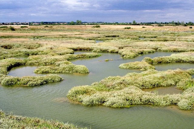
The Short Walk is the more compact introduction to Old Hall's grazing marsh and brackish water. The Long Walk follows the seawall around a broader sweep of the reserve, adding views over saltmarsh and the Blackwater Estuary. Take the official route information with you and choose one of these established routes, leaving offshore islands and grazing compartments to the wildlife. The two viewing screens midway around the Long Walk give a purpose to a patient stop. Their open setting suits an unhurried scan across the wetland rather than a quick arrival and departure. Study ducks on the fleets, then turn to the reeds and the horizon for marsh harriers. A distant flock may change shape and reveal species as it moves; waiting often improves identification without approaching. Two-hour plan: use the Short Walk only if the day's surface, walking pace and stopping time genuinely allow it. Otherwise make a shorter out-and-back from the public entrance, with a substantial watch across a productive pool before returning. Two hours should not be used to promise the Long Walk or to rush the birdwatch through every possible view. Full-day plan: when conditions suit, take the Long Walk with a packed meal and generous pauses at the screens and estuary outlook. Start with the nearer fleets, watch the saltmarsh as the tide changes, then use the return to inspect the reeds in different light. At weekends add the public approach walk from Tollesbury or Salcott to the day's total. On a weekday keep the car park's closing time as a firm boundary rather than the point at which to begin the last long section.
Use the linked reserve map and directions with current access notices. Species are typical seasonal targets. Light and telescope advice reflects our choice of viewpoint.
Bale Field grazing marsh and wetland from the signed Short Walk
The three-mile Short Walk has gates, stiles, grass paths and rough tracks; unsuitable for wheelchairs and pushchairs.
Winter: Brent Goose, Wigeon, Lapwing
Spring: Avocet, Lapwing, Redshank
Summer: Avocet, Redshank, Common Tern
Autumn: Lapwing, Wigeon
Light: either. Scope: useful.
Pennyhole Fleet open water and reed edges
One of two screens midway round the Long Walk. Narrow muddy grass approach and steps; no seating or shelter.
Winter: Shoveler, Pochard
Spring: Shoveler, Pochard
Summer: Pochard, Marsh Harrier
Autumn: Shoveler, Marsh Harrier
Light: either. Scope: useful.
Pennyhole Bottom wetland and grazing-marsh water
Stepped screen on the Long Walk; no seating, ramp or shelter. The full route is six miles.
Winter: Shoveler, Wigeon
Spring: Shoveler, Pochard
Summer: Pochard, Marsh Harrier
Autumn: Wigeon, Shoveler
Light: either. Scope: useful.
Intertidal creeks, mudflats and adjoining reedbeds from the permitted seawall
Six-mile natural-surface circuit with gates, stiles and seawall slopes. Stay on the wall; no mudflat or offshore-island access is suggested.
Winter: Brent Goose, Curlew, Dunlin, Grey Plover, Teal, Goldeneye, Red-breasted Merganser
Spring: Shelduck, Redshank, Bearded Tit
Summer: Marsh Harrier, Bearded Tit
Autumn: Spotted Redshank, Greenshank, Bearded Tit
Light: either. Scope: essential.
Tide: Creek feeding space changes with the tide; county guidance specifically recommends high-water scans for Goldeneye and Red-breasted Merganser.
Bushes and scrub beside the public Short Walk near the entrance
Watch from the path. Do not enter scrub, investigate singing-bird cover, or leave gates open.
Winter: Fieldfare, Redwing
Spring: Whitethroat, Lesser Whitethroat, Chiffchaff, Cetti’s Warbler, Cuckoo
Summer: Whitethroat, Lesser Whitethroat
Autumn: Chiffchaff, Cetti’s Warbler
Light: either. Scope: not needed.
| Spot | Overlooks | Key species by season | Best light | Scope | Tide |
|---|---|---|---|---|---|
| Short Walk: Bale FieldThe three-mile Short Walk has gates, stiles, grass paths and rough tracks; unsuitable for wheelchairs and pushchairs. | Bale Field grazing marsh and wetland from the signed Short Walk | Winter: Brent Goose, Wigeon, Lapwing Spring: Avocet, Lapwing, Redshank Summer: Avocet, Redshank, Common Tern Autumn: Lapwing, Wigeon | either | useful | — |
| Pennyhole Fleet viewing screenOne of two screens midway round the Long Walk. Narrow muddy grass approach and steps; no seating or shelter. | Pennyhole Fleet open water and reed edges | Winter: Shoveler, Pochard Spring: Shoveler, Pochard Summer: Pochard, Marsh Harrier Autumn: Shoveler, Marsh Harrier | either | useful | — |
| Pennyhole Bottom viewing screenStepped screen on the Long Walk; no seating, ramp or shelter. The full route is six miles. | Pennyhole Bottom wetland and grazing-marsh water | Winter: Shoveler, Wigeon Spring: Shoveler, Pochard Summer: Pochard, Marsh Harrier Autumn: Wigeon, Shoveler | either | useful | — |
| Long Walk: public seawallSix-mile natural-surface circuit with gates, stiles and seawall slopes. Stay on the wall; no mudflat or offshore-island access is suggested. | Intertidal creeks, mudflats and adjoining reedbeds from the permitted seawall | Winter: Brent Goose, Curlew, Dunlin, Grey Plover, Teal, Goldeneye, Red-breasted Merganser Spring: Shelduck, Redshank, Bearded Tit Summer: Marsh Harrier, Bearded Tit Autumn: Spotted Redshank, Greenshank, Bearded Tit | either | essential | Creek feeding space changes with the tide; county guidance specifically recommends high-water scans for Goldeneye and Red-breasted Merganser. |
| Short Walk: scrub east of car parkWatch from the path. Do not enter scrub, investigate singing-bird cover, or leave gates open. | Bushes and scrub beside the public Short Walk near the entrance | Winter: Fieldfare, Redwing Spring: Whitethroat, Lesser Whitethroat, Chiffchaff, Cetti’s Warbler, Cuckoo Summer: Whitethroat, Lesser Whitethroat Autumn: Chiffchaff, Cetti’s Warbler | either | not needed | — |
Month chips show typical presence or our preferred viewing season. Choose birds that suit the time of your visit.
Compare feeding waders as the water moves and scan the creeks around high tide for Goldeneye and Red-breasted Merganser, as the county site guide recommends. Stay on the official seawall and never approach roosting birds or offshore islands. No minimum tide height or fixed arrival offset is verified.
The RSPB describes the Short Walk as three miles on natural grass paths and rough hardcore, and the Long Walk as six miles around the seawall. Both have gates, steps and stiles, and are specifically described as unsuitable for wheelchairs and pushchairs. Most of the terrain is flat, but the ascent and descent of the seawall still involve steps or a gentler slope. Two benches with armrests are listed on the Short Walk. The Long Walk's screens have no seating and are approached by a narrow grass path that can become very muddy, with steps as well. A person who needs frequent seated rests should weigh those details carefully before choosing the longer route. No accessible toilet is provided at the reserve. The RSPB gives the nearest public accessible toilet as Tiptree, about six miles away, with RADAR-key access. Confirm that a suitable facility will be available before starting a walk that offers few opportunities to shorten the return. Discuss any specific mobility need with the reserve team rather than relying on the general flatness of the marsh.
There are two cycle racks and a picnic area, but no reserve toilets, baby changing, café or shop. The RSPB identifies Tollesbury and Tolleshunt D'Arcy for food and drink, with Tiptree for public toilet facilities. Take enough water and lunch for the intended circuit, particularly when walking in from a village at the weekend. Carry weather protection and a bag for litter. There is no indoor reception or sheltered hide to provide a break from an exposed estuary walk.
Dogs must remain on a lead and under close, effective control throughout the visit, protecting sensitive wildlife, habitats and livestock. Visitors with assistance dogs are welcome at RSPB Old Hall Marshes. There are no dog-waste bins on the reserve, so take waste home and keep bags secure rather than leaving them beside a gate.
The RSPB identifies Kelvedon as the nearest railway station, with an onward connection towards Tollesbury. For a dependable car-free plan, arrange a taxi from Kelvedon to the correct visitor gateway and book the return before beginning the walk. On a weekday that may be the reserve's Old Hall Lane entrance; on a weekend use a lawful pedestrian approach agreed with the reserve. The operator's location page mentions buses to Tollesbury followed by approximately two miles on foot along the seawall, but does not supply a current route number. The Essex service 91 PDF found during the check was dated August 2017, so its departures are not presented as a 2026 timetable. Confirm the current bus with the transport operator before relying on that alternative. Public paths also approach from Salcott. Carry a map for either village connection and add it to the reserve walking distance. A road journey estimate to Old Hall Lane describes the weekday arrival point; it does not resolve the separate weekend parking restriction.
Useful bases for an early start.
Booking.com links are affiliate links: we may earn a commission at no extra cost to you. How these links work.
About 9.2 miles by road, roughly 16 minutes’ drive to the reserve arrival point (OSRM, measured 18 October 2026; an estimate without live traffic).
Measured driving route · 18 October 2026. Map estimates exclude live traffic.
A base in Maldon suits a longer break that includes RSPB Old Hall Marshes.Find places to stay in Maldon on Booking.comAbout 13.2 miles by road, roughly 23 minutes’ drive to the reserve arrival point (OSRM, measured 18 October 2026; an estimate without live traffic).
Measured driving route · 18 October 2026. Map estimates exclude live traffic.
A base in Colchester suits a longer break that includes RSPB Old Hall Marshes.Find places to stay in Colchester on Booking.comAbout 5.7 miles by road, roughly 11 minutes’ drive to the reserve arrival point (OSRM, measured 18 October 2026; an estimate without live traffic).
Measured driving route · 18 October 2026. Map estimates exclude live traffic.
A base in Tiptree suits a longer break that includes RSPB Old Hall Marshes.Find places to stay in Tiptree on Booking.comExplore Essex’s full guides and smaller birding sites
The RSPB publishes oldhallmarshes@rspb.org.uk and 01621 869015. Its address is Old Hall Marshes, Old Hall Lane, Maldon, Essex, CM9 8TP. Contact the team about a weekend pedestrian approach, the current condition of the seawall route or a planned group visit. Use the official reserve pages for the parking rule and trail information. Transport operators should confirm the separate bus or rail leg, especially where an older timetable remains visible in search results.
Check Essex Birdwatching Society: genuine dated county reports. most days Reports show what has been seen, not what will be.
Follow the BTO Birders’ Code and give wildlife space.
RSPB Old Hall Marshes: Free entry and parking; car park closed at weekends.
RSPB Old Hall Marshes: Dogs must remain on a lead and under close, effective control throughout the visit, protecting sensitive wildlife, habitats and livestock.
RSPB Old Hall Marshes: Winter wildfowl; spring waders and autumn passage.
RSPB Old Hall Marshes: Both have gates, steps and stiles, and are specifically described as unsuitable for wheelchairs and pushchairs.
RSPB Old Hall Marshes: The RSPB identifies Kelvedon as the nearest railway station, with an onward connection towards Tollesbury.
Shorter stops within 15 miles in a straight line. Use the operator’s arrival directions for the journey.
Coast Road, West Mersea · Harbour, boats and Blackwater Estuary outlook
Seaview Avenue, West Mersea · Beach-hut seafront and Blackwater Estuary outlook
Public path and seawall beside St Peter’s Chapel, Bradwell-on-Sea · Coastal seawall, saltmarsh outlook, shore and scrub
Heath entrance, Tiptree · Lowland heath, rough grassland, scrub and ponds
Chigborough Road, Heybridge; nearest postcode, not the precise entrance · Former gravel pits, lakes, willow carr, marsh and grassland
Broman’s Lane, East Mersea · Coastal grassland, grazing meadow, pond and estuary views
South Green Road, Fingringhoe, Colchester · Colne Estuary saltmarsh, intertidal lagoon, scrub, woodland and freshwater pools
Blue House Farm Chase, North Fambridge · Coastal grazing marsh, wet grassland and estuary
Back Lane, Braintree · Ancient woodland, ponds and meadows
Ferrers Road approach, South Woodham Ferrers · Saltmarsh, rough grassland, creek and scrub
South Woodham Ferrers, River Crouch · Grazing marsh, borrow dykes and tidal riverside
Near Assington, south-west Suffolk · Ancient woodland, regenerating scrub, wet meadow and fen
Manningtree · Estuary and wet grassland
Nearby complete guides.
Stops with a purpose: use one as a contrasting habitat or weather-proof Plan B. Distances are straight-line estimates, not road journeys.